Otis Pike Fire Island High Dune Wilderness
| Otis Pike Fire Island High Dune Wilderness | |
|---|---|
|
IUCN category Ib (wilderness area) | |
|
Fire Island Wilderness | |
 | |
| Location | Fire Island, New York, USA |
| Nearest city | Brookhaven |
| Coordinates | 40°42′42″N 72°55′42″W / 40.711667°N 72.928333°WCoordinates: 40°42′42″N 72°55′42″W / 40.711667°N 72.928333°W |
| Area | 1,380 acres (5.6 km2; 2.16 sq mi) |
| Established | 1980 |
| Governing body | National Park Service |
The Otis Pike Fire Island High Dune Wilderness, also known as the Otis G. Pike Wilderness Area or the Fire Island Wilderness, is a federally protected wilderness area located on Fire Island, a barrier island off the south shore of Long Island, New York, United States. The 1,380-acre (5.6 km2; 2.16 sq mi) wilderness is contained within the larger Fire Island National Seashore.[1]
The wilderness area, named for former New York congressman Otis G. Pike, is the only federally designated wilderness area in New York State, and one of the smallest wilderness areas managed by the National Park Service.[1]
Description
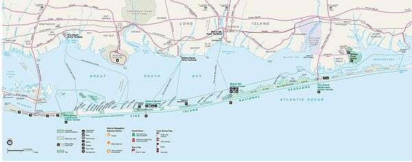
The Otis G. Pike Wilderness area is located on Fire Island, a barrier island along Long Island's south shore that is about 32 miles (51 km) long and 0.5 miles (0.80 km) wide at the widest point.[2] The 1,380-acre (5.6 km2; 2.16 sq mi) wilderness area is approximately seven miles (11 km) long and located on the eastern side of Fire Island. As part of the Fire Island National Seashore, it is managed by the National Park Service, and is the only federally designated wilderness in New York State.[1]
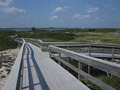
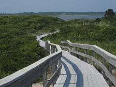
The wilderness includes pine forests, grassy wetlands, and dunes that serve as habitat for white-tailed deer, herons and migratory waterfowl. The wilderness area does not technically include the beaches that face the Atlantic Ocean. Hiking, back-country camping, and fishing access are available within the wilderness.[2]
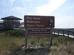
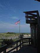
The wilderness is 50 miles (80 km) east of New York City. Access to the Otis G. Pike Wilderness can be obtained either from Watch Hill (which is accessible seasonally by ferry or private boat) or Smith Point County Park, accessible year round by car or bus. The Wilderness Visitor Center is located on the eastern edge of the wilderness, adjacent to Smith Point County Park.[2] Privately owned Bellport Beach is located near the central area of the wilderness.[3]
History
The United States Congress designated the Otis Pike High Dune Wilderness Area in 1980. The wilderness area is named for former New York Congressman Otis G. Pike, who co-sponsored the bill which created the Fire Island National Seashore and worked hard to secure public support and the legislation's passage through Congress to establish the new national park.
Old Inlet breach
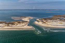
Old Inlet, just west of Smith Point County Park in the wilderness, has been the site of breaches of Fire Island causing the Atlantic Ocean to join with the Great South Bay.
The most recent breach occurred during the high tides associated with Hurricane Sandy in October 2012.[4] The breach was 276 feet (84 m) wide on the Atlantic side a week after the storm and 856 feet (261 m) wide on April 5, 2013.[5]
National Park Service officials have been debating whether to take action to close the breach. Contingency plans put in place to manage breaches within the wilderness area called for initial monitoring of the breach; as of 2014, the breach has stabilized and monitoring continues.[4] Although some residents have called for closure of the breach, due to perceived increases in flooding after the breach's opening,[5] the breach has been responsible for increased water quality in Great South Bay, which had been becoming increasingly polluted by suburban runoff prior to the breach's formation.[6]
Officials moved to close two breaches which formed on either side of Moriches Inlet following Hurricane Sandy — one in Cupsogue Beach County Park and the other in Smith Point County Park.[7] As of 2015, a final decision on whether to close the Old Inlet breach has not been made, although a draft plan for action is scheduled to be released in summer 2016.[8]
See also
Photo gallery


References
- 1 2 3 "Fire Island Wilderness - Fire Island National Seashore". NPS.gov. U.S. National Park Service. Retrieved November 22, 2015.
- 1 2 3 "Otis Pike Fire Island High Dune Wilderness - General Information". Wilderness.net. The University of Montana. Retrieved November 22, 2015.
- ↑ "Fire Island National Seashore Map". NPS.gov. U.S. National Park Service. Retrieved November 24, 2015.
- 1 2 "Post-Hurricane Sandy: Old Inlet Breach on Fire Island - Fire Island National Seashore". NPS.gov. U.S. National Park Service. Retrieved April 6, 2013.
- 1 2 Foderaro, Lisa W. (April 5, 2013). "Breach Through Fire Island Also Divides Opinions". The New York Times. Retrieved November 22, 2015.
- ↑ Goldberg, Barbara (October 28, 2014). "Sandy's silver lining: Clean water in long-polluted Long Island bay". Reuters.com. Retrieved November 23, 2015.
- ↑ Bolger, Timothy (March 14, 2013). "Fire Island Breach Needs to be Closed, Bellone Says". Long Island Press. Retrieved April 6, 2013.
- ↑ Leuzzi, Linda (September 10, 2015). "Public input wanted on Old Inlet". Long Island Advance. Retrieved November 23, 2015.
External links
- Fire Island Wilderness - National Park Service
- Otis Pike Fire Island High Dune Wilderness - Wilderness.net