Croton Aqueduct
|
Old Croton Aqueduct | |
|
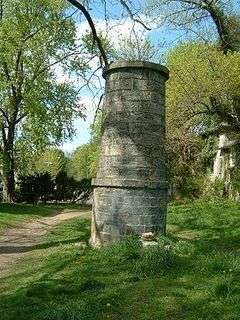
Ventilator No. 16, Irvington, New York (May 2005) | |
|
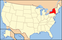
Location of Croton Aqueduct | |
| Nearest city | New York City, New York |
|---|---|
| Built | 1837-1842 |
| Architect | John B. Jervis; David Douglass; James Renwick, Jr. |
| NRHP Reference # | 74001324 |
| Significant dates | |
| Added to NRHP | December 2, 1974[1] |
| Designated NHL | April 27, 1992[2] |
The Croton Aqueduct or Old Croton Aqueduct was a large and complex water distribution system constructed for New York City between 1837 and 1842. It was one of the first great modern aqueducts and transported water by the force of gravity alone 41 miles (66 km) from the Croton River in Westchester County into reservoirs in Manhattan, where local water resources had become polluted and inadequate for the growing population of the city. Although the aqueduct was supplemented and largely superseded by the New Croton Aqueduct, which was built in 1890, the Old Croton Aqueduct remained in service until 1955.[3]
Background
The island of Manhattan, surrounded by brackish rivers, had a limited supply of fresh water available, which dwindled as the city grew rapidly after the American Revolutionary War, and fresh water sources became polluted by effluent. Before the aqueduct was constructed, residents of New York obtained water from cisterns, wells, natural springs, and other bodies of water. But rapid population growth in the 19th century, and encroachment on these areas as Manhattan moved further north of Wall Street, led to the pollution of many local fresh water sources. Below Grand Street, a small number of well-off customers of the Manhattan Company had fresh water delivered to them, but that company was actually more focused on banking – it eventually became Chase Manhattan – and only paid as much attention on its water activities as it needed to not lose the state charter that allowed it to bank.[4] The poor and the rest of the city were forced to rely on well water, often made palatable by adding alcoholic spirits, prompting temperance campaigners to call vigorously for the municipal provision of water.
The unsanitary conditions caused an increase in disease. Epidemics of yellow fever ravaged the city. A polluted aquifer, overcrowded housing, the lack of sewers, public ignorance of basic sanitary conditions, and the existence of polluting industries near wells and residential areas contributed to an unprecedented mortality rate of 2.6% (1 death per 39 inhabitants) in 1830. Then in 1832 cholera first reached New York in the deadliest epidemic to that date.
Construction

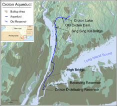
The need for a new supply of fresh water was crucial and was prompted by the Great Fire of New York in 1835. In 1837 construction began on a massive engineering project, to divert it from sources upstate, following a route surveyed by Major David Bates Douglass, engineering professor at West Point Military Academy,[5] and supervised by Douglass' successor, Chief Engineer John B. Jervis.[6] The Croton River was dammed, aqueducts were built, tunnels dug, piping laid and reservoirs created. The gravity-fed aqueduct dropped 13 inches per mile, 1/4" per 100' (~0.02%). An elliptical tube, 8.5 feet (2.6m) high by 7.5 feet (2.3m) wide, of iron piping encased in brick masonry was laid, sometimes in cuts, with conical ventilating towers every mile or so, to relieve pressure and keep the water fresh. Hydraulic cement was added where the aqueduct crossed rivers. It extended from the Croton Dam in northern Westchester County to the Harlem River, where it continued over the High Bridge at 173rd Street and down the West Side of Manhattan and finally into a Receiving Reservoir located between 79th and 86th streets and Sixth and Seventh Avenues; the site is now the Great Lawn and Turtle Pond in Central Park.[7] The Receiving Reservoir was a rectangular tank within fortress-like rusticated retaining walls, 1,826 feet (557 m) long and 836 feet (255 m) wide; it held up to 180,000,000 US gallons (680,000 m3) of water. 35,000,000 US gallons (130,000 m3) flowed into it daily from northern Westchester.

From the Receiving Reservoir water flowed down to the Distributing Reservoir, better known simply as the Croton Reservoir, a similar fortified tank located on Fifth Avenue between 40th Street and 42nd Street, where the main branch of the New York Public Library and Bryant Park are located today. This reservoir was built to resemble ancient Egyptian architecture. New Yorkers came up from town for the fine view of the city obtained from atop its walls.

The Aqueduct opened to public use with great fanfare on October 14, 1842. The day-long celebration culminated in a fountain of water that spouted to a height of 50 feet (15 m) from the beautifully decorated cast-iron Croton Fountain in City Hall Park. Among those present was James Renwick, Jr., who went on to design Grace Church, New York, the Smithsonian Institution Building in Washington, DC, and St. Patrick's Cathedral, New York, and was involved in the architectural and engineering work on the Aqueduct as an up-and-coming 18-year-old.
Impact on the city
Water started flowing through the aqueduct on June 22, 1842, taking 22 hours for gravity to take the water the 41 miles (66 km) (at a velocity of 1.86 miles per hour [2.99 km/h; 2.73 ft/s]) to reach Manhattan.[6] Even though only 6,175 houses had been connected to the system by 1844, the Croton water had already dramatically improved both domestic hygiene and interior design. Baths and running water were being built in the private homes of wealthy New Yorkers and public bathing facilities were constructed for the masses. The water system had another inadvertent consequence. The decline in the number of residents drawing water from the city's wells resulted in a rise in the water table which flooded many cellars. To address this problem, the city built sewers in many residential streets. By 1852, 148 miles (238 km) of sewers had already been constructed.
About this time the German cockroach attracted attention, and was called "Croton bug" on the mistaken belief that the aqueduct brought the insects into the homes being connected to the new water supply system.[8]
Despite its size, the capacity of the Old Croton Aqueduct could not keep up with the growth of New York City, and construction on a New Croton Aqueduct began in 1885 a few miles east. The new aqueduct, buried much deeper than the old one, went into service in 1890, with three times the capacity of the Old Croton Aqueduct. It currently supplies ten percent of New York City's water. The Croton Receiving Reservoir continued to supply New York City with drinking water until 1940, when Commissioner of Parks and Recreation Robert Moses ordered it drained and filled to create the Great Lawn in Central Park. The old aqueduct remained in service until 1955; in 1987 the northernmost portion was re-opened to provide water to Ossining.[9]
Old Croton Trail
| Old Croton Trail | |
|---|---|
| Length | 26.2 mi (42.2 km) |
| Location | Westchester County, New York, U.S. |
| Trailheads |
Van Cortlandt Park, New York Croton Gorge Park, New York |
| Use | Hiking, Biking, Jogging |
| Hiking details | |
| Trail difficulty | Easy |
| Season | Year round |
| Sights | Lyndhurst |
| Hazards | Poison ivy |
The Old Croton Trail extends for 26.2 miles (42.2 km) in Westchester County, New York, providing public access along all but four segments – in the Getty Square neighborhood of downtown Yonkers, Tarrytown, Scarborough and Ossining – of the route of the aqueduct. It crosses the lawn of Lyndhurst, following the aqueduct's easement. The Trail enters New York City on the eastern side of Van Cortlandt Park[6] and runs through the Bronx alongside Aqueduct Avenue, and the Aqueduct continues under the southern part of University Avenue.

Both trail and the tunnel comprise the Old Croton Aqueduct State Historic Park,[10] which was created in 1968 and encompasses the northernmost 26 miles (42 km) of the Aqueduct and its right-of-way, from Croton Gorge Park to the Yonkers-New York City line. It lies wholly within Westchester County, but is under the jurisdiction of the Taconic Region of the New York State Office of Parks, Recreation and Historic Preservation.[11]
The trail runs roughly parallel to Metro North's Hudson Line from northern Yonkers to Scarborough and is accessible from numerous stations on that line. The trail briefly parallels the Rockefeller State Park Preserve and its trails. Access to the trail is easiest where it crosses Route 9, known variously as Albany Post Road, Broadway or Highland Avenue.
Heading southbound into downtown Yonkers, the trail goes on-street at Bishop William J. Walls Place and N. Broadway, where it follows the sidewalk on N. Broadway for one block, and then makes a left onto Ashburton Avenue going east. At Palisades Avenue, it makes a right and the trail bed restarts.
Remnants of the aqueduct still exist and can be seen along the trail, including 21 stone ventilators, three stone weirs (chambers which were used to empty the aqueduct for maintenance), and one "Keeper's House" located in Dobbs Ferry.[12] The Keeper's House in Dobbs Ferry was built in 1857 and is the only remaining of four Keeper's Houses that is both on the Aqueduct, and open to the public. The only other remaining Keeper's House is located in Ossining, but it was moved off the Aqueduct, is privately owned, and not open to visitors.[13] A portion of the Old Croton Aqueduct, running from the Croton River to Manhattan, was listed as a National Historic Landmark in 1992.[2][14] The Croton Water Supply System was also designated as a National Historic Civil Engineering Landmark by the American Society of Civil Engineers in 1975.[15]
The interior of the Old Croton Aqueduct has been explored and documented by Miru Kim and “guerrilla historian” Steve Duncan.[16] The aqueduct also plays an important role in E. L. Doctorow's novel The Waterworks.
Gallery
 "Shutting off the Croton", from Harper's Weekly (November 12, 1881)
 A weir in Sleepy Hollow. The weir chambers were used to empty the aqueduct for maintenance by diverting the waters to a nearby waterway. The line could be emptied in two hours.[17]
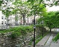 Croton Walk, south of Kingsbridge Road, Bronx
 119th Street gatehouse, Manhattan
 Stone building in Yonkers for shaft of New Croton Aqueduct
 1857 Keeper's House in Dobbs Ferry; open to the public.
 Inside the Old Croton Aqueduct at the weir in Ossining
See also
- Croton Aqueduct Gate House
- List of National Historic Landmarks in New York
- National Register of Historic Places listings in northern Westchester County, New York
- National Register of Historic Places listings in southern Westchester County, New York
References
Notes
- ↑ National Park Service (2007-01-23). "National Register Information System". National Register of Historic Places. National Park Service.
- 1 2 "Croton Aqueduct (Old)". National Park Service. National Historic Landmark summary listing. September 17, 2007. Archived from the original on 2014-08-13.
- ↑ "Cultural Resource Information System (CRIS)" (Searchable database). New York State Office of Parks, Recreation and Historic Preservation. Retrieved 2016-07-01. Note: This includes Lenore Rennenkampf (November 1973). "National Register of Historic Places Registration Form: Old Croton Aqueduct" (PDF). Retrieved 2016-07-01. and Accompanying six photographs
- ↑ Burrows, Edwin G. & Wallace, Mike (1999), Gotham: A History of New York City to 1898, New York: Oxford University Press, ISBN 0-195-11634-8 pp. 360, 362, 589
- ↑ A Trail through History (Old Croton Aqueduct Staste Park brochure).
- 1 2 3 "Old Croton Aqueduct Trail". New York City Department of Parks and Recreation. Retrieved September 19, 2007.
- ↑ "Great Lawn". Central Park Conservancy. Retrieved October 6, 2011.
- ↑ Cockroach insect information & pictures. Retrieved November 29, 2006.
- ↑ "An Engineering Marvel". Friends of the Old Croton Aqueduct. Retrieved September 16, 2012.
- ↑ "Old Croton Aqueduct State Historic Park". New York State Office of Parks, Recreation and Historic Preservation. Retrieved October 6, 2011.
- ↑ "History of the Aqueduct Trail". Friends of the Old Croton Aqueduct. Retrieved October 6, 2011.
- ↑ "Old Croton Aqueduct Trail Map" (PDF). New York State Office of Parks, Recreation and Historic Preservation. Retrieved April 2, 2016.
- ↑ "DEP Donates Century-Old Valve Actuator from New Croton Dam for Permanent Display at Education Center". New York City Department of Environmental Protection. December 9, 2015. Retrieved April 2, 2016.
- ↑ Lange, Robie S. (October 1991). "National Register of Historic Places Registration: Croton Aqueduct" (PDF). National Park Service. and Accompanying 20 photos and drawings, from 1978 and 1843. (6.95 MB)
- ↑ "Croton Water Supply System". ASCE Metropolitan Section. Retrieved November 12, 2016.
- ↑ Gibberd, Ben (July 29, 2009). "Children of Darkness". The New York Times. Retrieved September 15, 2009.
- ↑ Descriptive display at the weir chamber in Ossining, New York in the Old Croton Aqueduct State Historic Park. Accessed: September 6, 2010
Bibliography
- Chazin, Daniel D., ed. (2005). New York Walk Book (7th ed.). New York-New Jersey Trail Conference. ISBN 978-1-880775-30-1.
- Koeppel, Gerard T. (2000). Water for Gotham: A History. Princeton, N.J.: Princeton University Press. ISBN 0-691-01139-7.
- Rappole, George H. (1978). "The Old Croton Aqueduct". IA, The Journal of the Society for Industrial Archeology. 4 (1). pp. 15–25. JSTOR 40967954.
External links
| Wikimedia Commons has media related to Croton Aqueduct. |
- Old Croton Aqueduct State Historic Park
- Friends of the Old Croton Aqueduct
- NYC Segment
- ASCE History and Heritage of Civil Engineering - Croton Water Supply System
- "Croton Aqueduct" in 1902 Encyclopedia
- "The New Croton Aqueduct New York" Scientific American (1890-07-12)
- John B. Jervis Drawings Collection of the Jervis Public Library on New York Heritage Digital Collections
- Account of the New York Guard protection of the aqueduct in World War I
- HAER No. NY-120, "Old Croton Aqueduct, New York, New York County, NY", 53 photos, 1 measured drawing, 185 data pages, 7 photo caption pages
- HAER No. NY-119, "Old Croton Aqueduct, Harlem River Crossing, Spanning Harlem River, Bronx, Bronx County, NY", 13 photos, 2 data pages, 2 photo caption pages
- HAER No. NY-117, "Old Croton Aqueduct, Quarry Railroad Bridge, Aqueduct Lane at Williams Street, Hastings-on-Hudson, Westchester County, NY", 3 photos, 2 data pages, 1 photo caption page
- HAER No. NY-110, "Old Croton Aqueduct, Sing Sing Kill Bridge, Spanning Aqueduct Street & Broadway, Ossining, Westchester County, NY", 18 photos, 4 measured drawings, 2 data pages, 2 photo caption pages
- HAER No. NY-112, "Old Croton Aqueduct, Mill River Culvert, U.S. Route 9 at Sleepy Hollow Cemetery, Tarrytown, Westchester County, NY", 7 photos, 1 color transparency, 3 measured drawings, 3 data pages, 2 photo caption pages
- HAER No. NY-113, "Old Croton Aqueduct, Mill River Waste Weir, U.S. Route 9 at Sleepy Hollow Cemetery, Tarrytown, Westchester County, NY", 5 photos, 3 measured drawings, 2 data pages, 1 photo caption page
- HAER No. NY-114, "Old Croton Aqueduct, Jewels Brook Culvert, Spanning Station Road, Irvington, Westchester County, NY", 8 photos, 4 measured drawings, 2 data pages, 1 photo caption page
- HAER No. NY-115, "Old Croton Aqueduct, Overseer's House, Walnut Street, Dobbs Ferry, Westchester County, NY", 2 measured drawings
- HAER No. NY-116, "Old Croton Aqueduct, Maintenance Building, Walnut Street, Dobbs Ferry, Westchester County, NY", 1 measured drawing
- HAER No. NY-118, "Old Croton Aqueduct, Saw Mill River Culvert, Spanning Nepperhan Avenue, Yonkers, Westchester County, NY", 19 photos, 3 measured drawings, 5 data pages, 2 photo caption pages
- HAER No. NY-207, "Old Croton Aqueduct, Ventilator No. 10, North of Scarborough Road, Briarcliff Manor, Westchester County, NY", 1 photo, 1 photo caption page
- HAER No. NY-208, "Old Croton Aqueduct, Ventilator No. 18, South of Main Street, Irvington, Westchester County, NY", 1 photo, 1 photo caption page
- HAER No. NY-111, "Old Croton Aqueduct, Ventilator No. 9, Spring & Everett Streets, Ossining, Westchester County, NY", 1 photo, 1 color transparency, 1 measured drawing, 3 data pages, 2 photo caption pages
- HAER No. NY-109, "Old Croton Aqueduct, Northern Waste Weir, Snowden Avenue & Van Wick Street, Ossining, Westchester County, NY", 4 photos, 2 measured drawings, 2 data pages, 1 photo caption page
- HAER No. NY-108, "Old Croton Aqueduct, Indian Creek Culvert, Reservoir & Quaker Bridge Roads, Crotonville, Ossining, Westchester County, NY", 5 photos, 3 measured drawings, 2 data pages, 1 photo caption page
- HAER No. NY-107, "Old Croton Aqueduct, Entrance Entablature, New Croton Reservoir, Yorktown Heights, Westchester County, NY", 1 photo, 1 measured drawing, 2 data pages, 1 photo caption page
- HAER No. NY-132, "New Croton Dam & Reservoir, Croton River, Croton-on-Hudson, Westchester County, NY", 22 photos, 7 color transparencies, 3 data pages, 3 photo caption pages