Otočac
| Otočac | |
|---|---|
| Municipality | |
|
Park in Otočac | |
 Otočac Location of Otočac within Croatia | |
| Coordinates: 44°52′N 15°14′E / 44.867°N 15.233°E | |
| Country |
|
| County |
|
| Government | |
| • Mayor | Stjepan Kostelac (Ind.) |
| Area | |
| • Land | 1,460 km2 (565 sq mi) |
| Population (2001)10,411 (municipality) | |
| • Total | 4,354 |
| Time zone | CET (UTC+1) |
| • Summer (DST) | CEST (UTC+2) |
| Postal code | 53220 |
| Area code(s) | 053 |
| Website | otocac.hr |


Otočac (pronounced [ɔtɔ̌tʃats]; German: Ottochaz, Latin: Ottocium) is a town in Croatia, former bishopric and present Latin Catholic titular see. It lies in the northwestern part of Lika region, in the Gacka river valley. The population of the town is 4,354 as of 2001, with a total of 10,411 people within the municipality at large, the majority of whom are Croats (91%), the number having risen exponentially since the Croatian War of Independence, before which Croats comprised 65% and Serbs 31% of the town's population.
History
Otočac was named after the early Croatian parish. The text of the famous Baška Tablet (around 1100) says that the church of St. Nicholas in Otočac was part of the order community with the Church of St. Lucy, Jurandvor on the island of Krk. From 1300 on, it belonged to the estate of the Frankopan family. Sigismund Frankopan (1461–1535) founded a diocese there (see below). The settlement with a defence tower, at a bend in the river Gacka, was protected by a towered fort. After the fort's demolition in 1829, only parts remained preserved. To provide a safer defence, a Renaissance-era castle ("Fortica") was built in 1619, with a triangular layout of cylindrical towers (these ruins stand above the town).
The Baroque parish church of the Holy Trinity, erected in 1684 (restored in 1774), is a large one-nave building with rounded sanctuary; three side chapels are on each side of the nave. The bell tower rises from the main front. The late baroque and classicist furnishings of the church include seven altars, a pulpit, baptismal font and sepulchral slabs from the 18th century.
From 1746, Otočac was the headquarters of a regiment (Ottotschaner Grenz-Infanterie Regiment N°II) of the Croatian Military Frontier, (Croatian Vojna Krajina). A number of harmonious, simple, mostly two-story houses originate from this period. Until 1918, Otočac (named OTTOCSAZ before 1850) was part of the Austrian monarchy (Kingdom of Croatia-Slavonia after the compromise of 1867).[1] In the late 19th century and early 20th century, Otočac was part of the Lika-Krbava County of the Kingdom of Croatia-Slavonia.
During World War II, Otočac was part of the Independent State of Croatia. At least 331 Serbs were liquidated and an Orthodox priest, Branko Dobrosavljević, was forced to pray in front of the tortured and dying while his young son lay literally cut into pieces before his eyes. Then the priest's hair and beard were torn off, his eyes were gouged out, and he was tortured until he died.[2]
Ecclesiastical History
A bishopric was established in 1460, on territory split off from the Roman Catholic Diocese of Senj, which local estate owner Sigismund Frankopan (1461–1535) founded at the church of St. Nicholas and Jelena (née Keglević), widow of Juraj Mikuličić, who was a member of the community of the Divine Holy Spirit in Rome, gave to the church three parcels of land.[3][4] Initially it was suffragan of the Metropolitan Archdiocese of Salona, later of the Archdiocese of Split. In 1534 it was suppressed and its territory returned to its mother diocese of Senj.
Residential Suffragan Bishops
- Biagio Nicolai (1460.06.04 – death 1492?)
- Giovanni Chericato, Crosier Canons (O.Cruc.) (1492.05.09 – 1493.08.16), later Bishop of Kotor (Montenegro) (1493.08.16 – death 1514)
- Vincenzo de Andreis (1493.09.06 – 1520?)
- Pietro de Andreis (1520.10.19 – 1534?)
Titular see
It was nominally restored in 1933 as a titular bishopric. It had had the following incumbents, of the lowest (episcopal) rank :
- Patrick Webster, Benedictine Order (O.S.B.) (1969.06.26 – 1970.03.07) as Auxiliary Bishop of Saint George’s in Grenada (Grenada) (1969.06.26 – 1970.03.07) and as Apostolic Administrator of Saint George’s in Grenada (1969.08.05 – 1970.03.07), succeeding as Bishop of Saint George’s in Grenada (1970.03.07 – 1974.11.18), later Metropolitan Archbishop of Castries (Saint Lucia) (1974.11.18 – 1979.05.10)
- Maurice Paul Delorme, Prado (1975.10.02 – 2012.12.27)
- Joaquím Humberto Pinzón Güiza, Consolata Missionaries (I.M.C.) (2013.02.21 – ...), Apostolic Vicar of Puerto Leguízamo–Solano (Colombia)
Demographics
According to 2001 census, the municipality had 10,411 inhabitants, of whom 91.29% were Croats and 6.63% were Serbs. Croats in the vicinity of Otočac form two groups, those who speak Chakavian dialect and Bunjevci, who speak Shtokavian dialect with an Ikavian accent. Serbs form a majority in the villages of Gorići and Staro Selo. The town itself had population of 4,354.
Before the Croatian War of Independence, the 1991 census lists the greater municipality of Otočac as having 24,992 inhabitants, with 16,355 Croats (65.44%) and 7,781 Serbs (31.13%).
Geography
Otočac is located in the western part of the karst field of centrally located Gacka, located between Velebit and Mala Kapela, at an elevation of 459m. The town lies to the southeast of Senj, northwest of Gospić and west of Plitvice.
There are two town sections, the Upper Town and Lower Town.
Towns and villages in the municipality
|
|
|
|
|
|
Gallery
.2.JPG) Guards wearing a traditional Lika uniform of the Military Frontier
Guards wearing a traditional Lika uniform of the Military Frontier Brown bear at the Kuterevo bear sanctuary
 Memorial to fallen Croatian defenders of the Croatian War of Independence
.JPG) Monument of Žikmund (Sigismund) Frankopan, Lord of the town in the 15th century
Monument of Žikmund (Sigismund) Frankopan, Lord of the town in the 15th century_-_Ulica_kralja_Zvonimira.jpg) King Zvonimir Street
King Zvonimir Street Otočac Airport
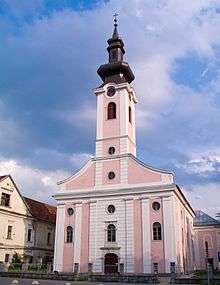 Holy Trinity Church
Notable natives and residents
References
- ↑ Edwin Mueller. Handbook of Austria and Lombardy-Venetia Cancellations on the Postage Stamp Issues 1850-1864, 1961.
- ↑ Karlheinz Deschner. God and the Fascists: The Vatican Alliance with Mussolini, Franco, Hitler, and Pavelic, Prometheus Books (7 October 2013); ASIN: B00CCOO6WU
- ↑ Bihać i biháćka krajina, str. 146, Radoslav Lopasić, Matica hrvatska, 1890.
- ↑ Monumenta spectantia historiam slavorum meridionalium, Volume 42-43, page XXXV, Croatian Academy of Sciences and Arts, Academia Scientiarum et Artium Slavorum Meridionalium, 1917.
Sources and External links
| Wikimedia Commons has media related to Otočac. |
Subdivisions of Lika-Senj County | ||
|---|---|---|
| Towns |  | |
| Municipalities | ||
Coordinates: 44°52′N 15°14′E / 44.867°N 15.233°E