Otta, Norway
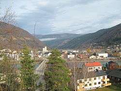

![]() Otta is a town in the municipality of Sel in the county of Oppland in Norway.
Otta is a town in the municipality of Sel in the county of Oppland in Norway.
The name
The town is named after the Otta river.
General information
It has 1,687 inhabitants per 1 January 2012[1] making it the largest settlement in the municipality Sel, of which it is the administrative centre.
Otta has a regional medical clinic.
The first three tiers of Norwegian education are covered by its primary and secondary schools and the high school, Otta vidaregående skule.
Geography
Situated 110 kilometers North from Lillehammer, it spans the valley floor where Ottadalen branches of Gudbrandsdal and the largely glacial fed, most of its 4,000 km^2 watershed being in a very arid region, the river Otta merges into Gudbrandsdalslågen
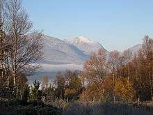
North-east lies the massif Rondane, which areas became the first national park in Norway in 1962, and has several mountains over 2,000 metres.
Transportation
Otta sits at roughly the midway point between Oslo and Trondheim along the (E6)European route E06, and the Rv15 starts here connected to the E6, heading west along Ottadalen and over the mountains to Stryn, along the Nordfjord, finally terminating in Måløy Otta is also an important link on the Dovre Line, since Otta Station is the only station in the valley where every single passing passenger train stops.
History
Otta as a place name came to be in 1896 when the rail road came to terminate here for a decade and some, until continuing to Dombås in 1912, ultimately being completed all the way to Trondheim in 1922; Before this location was called "Åmot" meaning "rivers against" signifying the meeting of the 2 major rivers. And the focus of activity lay 4–5 km further north where there in the 16-1800's was a copper and iron works, servicing the various mines up in the hills, this is also where the present-day Sel Church is located. Sel Church is the de facto town-church, Otta itself being one of very few towns in Norway, without a central church.
In 1612, it was the site of the Battle of Kringen.
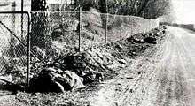
On 28 April 1940, Otta saw extensive fighting between German and British forces during the last parts of the German advance up the Gudbrandsdalen Valley, as part of the German conquest of Norway. Company C and D of the British Green Howards fought elements of the German 196th infantry division under Richard Pellengahr supported by artillery and tanks. Equipped with 25 mm Hotchkiss anti-tank guns and Boys anti-tank rifles, the British managed to disable three German tanks, including killing two crew members of a Panzerkampfwagen Ib with an anti-tank rifle, but by late evening, the British had to retreat due to fierce artillery fire from German 10.5 cm leFH 18 guns. The last British forces fought off the Germans in the dark with Bren light machine guns and hand grenades, while they retreated further north towards Dombås.[2]
Economy
Otta is a largely industrially geared town, having a number of factories; including a window framing plant, production of a high quality slate, wood mill(40,000M3/a) and a large printing plant. Though it also is well covered in most trades and services.
Attractions
Otta is used as a base for day/2 day trips into the Rondane National Park massif and northern parts of Jotunheimen Having a Hotel, a number of camping sites, and the so-called mountain hotels located near Mysusæter just on the south edge of the national park.
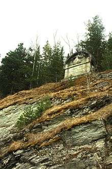
Points of interests include Kvitskriupresten and the Milorg hideout of Reiret, as well as a monument commemorating the Battle of Kringen in 1612.
See also
References
- ↑ Population statistics for Norway
- ↑ Hauge, Andreas (1995). Kampene i Norge 1940 (in Norwegian) 1. Sandefjord: Krigshistorisk Forlag. pp. 348-357. ISBN 82-993369-0-2.
| Wikimedia Commons has media related to Otta. |
| Wikivoyage has a travel guide for Otta. |
Coordinates: 61°46′N 9°32′E / 61.767°N 9.533°E