Pennsylvania Route 446
| ||||
|---|---|---|---|---|
 | ||||
| Route information | ||||
| Maintained by PennDOT | ||||
| Length: | 13.0 mi[1] (20.9 km) | |||
| Existed: | 1928 – present | |||
| Major junctions | ||||
| South end: |
| |||
|
| ||||
| North end: |
| |||
| Location | ||||
| Counties: | McKean | |||
| Highway system | ||||
| ||||

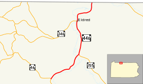
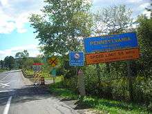
Pennsylvania Route 446 (PA 446) is an 13.0-mile-long (20.9 km) state highway located in McKean county in Pennsylvania. The southern terminus is at Route 46 in the Keating Township neighborhood of Farmers Valley. The northern terminus is at the New York state line near Portville, New York. Route 446 is mountainous for most of its length and its only street designation is Main Street. Route 446 is part of a family of routes interconnected with Pennsylvania Route 46. However, unlike several others, PA 446 does connect to its parent route and PA 346.
PA 446 was assigned in 1928 and used to be part of US 6 and PA 7.
Route description
PA 446 begins at a fork with its parent route, Route 46 in the Farmers Valley community of Keating Township. Here, the highway is almost 2,000 feet (610 m) above sea level. At the base of a mountain, Route 446 passes through the borough of Farmers Valley and passes to the north of a landmark called Diegel Hollow. The highway curves around the base of a mountain north of Prospect Hill. The highway passes Moody Hollow, where it turns northward. Route 446 enters Larabee and intersects with the northern terminus of Pennsylvania Route 155.[1]
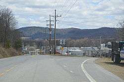
Route 446 leaves Larabee soon afterward, becoming surrounding on both sides by mountains. Although across a range of peaks, Pennsylvania Route 346 parallels to the west. As the highway edges towards the state line, it enters downtown Eldred. Just north of the borough, Route 346, which was paralleling earlier, now terminates at Route 446. The highway curves around a mountain and begins to follow the Allegheny River before crossing the line into New York. There it continues as New York State Route 305.[1]
History
PA 446 from Farmers Valley to Larabee used to be part of Pennsylvania Route 7, which was designated in 1925. The next year, PA 7 was assigned as U.S. Route 6 as well. PA 446 was assigned in 1928 from Larabee to the New York border.[2] In 1930, PA 446 was extended to Farmers Valley to its current southern terminus at PA 46.[3]
Major intersections
The entire route is in McKean County.
| Location | mi[1] | km | Destinations | Notes | |
|---|---|---|---|---|---|
| Keating Township | 0.0 | 0.0 | |||
| Eldred Township | Northern terminus of Route 155 | ||||
| Eldred | Eastern terminus of Route 346 | ||||
| Eldred Township | 13.0 | 20.9 | New York – Pennsylvania state line. | ||
| 1.000 mi = 1.609 km; 1.000 km = 0.621 mi | |||||
See also
 U.S. Roads portal
 Pennsylvania portal
References
| Wikimedia Commons has media related to Pennsylvania Route 446. |
- 1 2 3 4 Google (2008-05-04). "overview map of PA 446" (Map). Google Maps. Google. Retrieved 2008-05-04.
- ↑ Tourist Map of Pennsylvania (PDF) (Map). Pennsylvania Department of Highways. 1930. Retrieved 2008-05-04.
- ↑ Jeff Kitsko. "PA Highways - Route 546". PA Highways. Retrieved 2008-05-04.
External links
- Kitsko, Jeffrey J. (2011). "PA 446". Pennsylvania Highways. pp. 401–450. Retrieved November 28, 2011.