Pachatusan
Pachatusan (Quechua pacha earth, tusa, a prop to support a wall or building, pachatusa prop of the earth, -n a suffix) is a mountain northeast of the city of Cusco in the Andes of Peru, about 4,842 metres (15,886 ft) high. It is located in the Cusco Region, Calca Province, San Salvador District, in the Cusco Province, in the districts San Jerónimo and Saylla, and in the Quispicanchi Province, Oropesa District. It is situated on the western bank of the Willkanuta River, beside the mountain Waypun in the south-east.[2] Pachatusan lies above the sanctuary of San Salvador named Señor de Huanca.
By the local people Pachatusan is venerated as an apu.
On February 16, 2009, the cultural archaeological landscape of Pachatusan was declared a National Cultural Heritage by Resolución Directoral Nacional No. 231/INC.[3]
Gallery
See also
References
- ↑ conservation.org "Forests for Water in the Sacred Mountain "
- ↑ escale.minedu.gob.pe - UGEL map of the Calca Province (Cusco Region)
- ↑ Resolución Directoral Nacional No. 913/INC
|
|---|
|
- Acaray
- Amaru Marka Wasi
- Arhuaturo
- Asana
- Asiru Phat'jata
- Aspero
- Awila Qhincha Mach'ay
- Awkin Punta
- Awkillu Waqra
- Awkimarka (Apurímac)
- Awkimarka (Huánuco)
- Awqa Punta
- Aya Muqu
- Ayamach'ay
- Ayawayq'u
- Azángaro
- Baths of Boza
- Bandurria
- Buena Vista
- Cahuachi
- Cajamarquilla
- Cao Viejo
- Carajía
- Caral
- Caves of Sumbay
- Cerro Baúl
- Cerro Pátapo
- Cerro Trinidad
- Chakamarka
- Chan Chan
- Chankillo
- Chauchilla Cemetery
- Chavín de Huantar
- Chawaytiri
- Chichakuri
- Chipaw Marka
- Chuqik'iraw
- Chuqik'iraw Pukyu
- Chuqi Pukyu
- Churajón
- Chuya
- Ch'iqullu
- Cota Coca
- Cumbe Mayo
- El Brujo
- El Cañoncillo
- El Ingenio
- El Paraíso
- Garagay
- Gran Pajáten
- Gran Vilaya
- Guitarrero Cave
- Hatun Rumiyuq
- Hatun Mach'ay
- Hatun Misapata
- Hatun Uchku
- Hatun Usnu
- Hatunmarka
- Hunqupampa
- Inka Mach'ay
- Inka Raqay, Apurímac
- Inka Raqay, Ayacucho
- Inka Tampu, Cajamarca
- Inka Tampu, Huayopata
- Inka Tampu, Vilcabamba
- Inka Tunuwiri
- Inka Uyu
- Inka Wasi, Ayacucho
- Inka Wasi, Huancavelica
- Inka Wasi, Lima
- Inkapintay
- Inkill Tampu
- Inti Punku
- Inti Watana, Ayacucho
- Inti Watana, Calca
- Inti Watana, Urubamba
- Intikancha
- Intini Uyu Pata
- Intipa Ñawin
- Intiyuq K'uchu
- Iskuqucha
- Isuq
- Jinkiori
- Jisk'a Iru Muqu
- Kanichi
- Killa Mach'ay
- Killa Rumi
- Killarumiyuq
- Kiswar
- Kotosh
- Kuelap
- Kukuli
- Kuntur Wasi
- Kunturmarka, Ayacucho
- Kunturmarka, Pasco
- Kuntur Qaqa
- Kuntuyuq
- Kusichaka valley
- Kutimpu
- Khichuqaqa
- Khuchi Mach'ay
- K'allapayuq Urqu
- K'anamarka
- K'ipakhara
- Laguna de las Momias
- Lawriqucha
- Layzón
- Llamachayuq
- Llamachayuq Qaqa
- Llamayuq
- Llamuqa
- Llaqta Qulluy, Acoria
- Llaqta Qulluy, Conayca
- Llaqta Qulluy, Tayacaja
- Llaqta Qulluy, Vilca
- Llaqtan
- Llaqtapata
- Machu Pikchu
- Machu Pirqa
- Machu Pitumarka
- Machu Q'inti
- Machu Qullqa
- Mameria
- Maray Qalla
- Marayniyuq
- Markahirka
- Markansaya
- Markapukyu
- Markawamachuku
- Marpa
- Mawk'allaqta, Castilla
- Mawk'allaqta, Espinar
- Mawk'allaqta, La Unión
- Mawk'allaqta, Melgar
- Mawk'allaqta, Paruro
- Mawk'allaqta, Sandia
- Mawk'ataray
- Mayqu Amaya
- Mazur
- Mikulla
- Millka
- Miraflores
- Mirq'imarka
- Miyu Pampa
- Mulinuyuq
- Mullu Q'awa
- Mulluq'u
- Muray
- Muyu Muyu
- Muyu Urqu
- Muyuq Marka
- Nazca Lines
- Nina Kiru
- Ninamarka
- Ñawpallaqta, Huanca Sancos
- Ñawpallaqta, Fajardo
- Ñawpallaqta, Lucanas
- Ñust'a Hisp'ana
- Pacatnamu
- Pachakamaq
- Pachatusan
- Paiján
- Pañamarka
- Paracas Candelabra
- Paraxra
- Patallaqta
- Phiruru
- Pikillaqta
- Pikimach'ay
- Pilluchu
- Pinkuylluna
- Pirqa Pirqa, La Libertad
- Pirqa Pirqa, Lima
- Pirwalla
- Pirwayuq
- P'isaq
- Puka Pukara
- Puka Tampu
- Puka Urqu
- Pukara, Coporaque
- Pukara, Fajardo
- Pukara, Puno
- Pukara, Vilcas Huamán
- Pukarani
- Pumamarka, San Sebastián
- Pumamarka, Urubamba
- Pumaq Hirka
- Pumawasi
- Punkuri
- Puqin Kancha
- Puruchuco
- Purum Llaqta, Cheto
- Purum Llaqta, Soloco
- Pusharo
- Pusuquy Pata
- Phuyupatamarka
- Qaqapatan
- Qillqatani
- Quchapata
- Qillqa
- Qillqay Mach'ay
- Quchapampa
- Quiaca
- Qullqanpata
- Qullqapampa
- Qulu Qulu
- Qunchamarka
- Qunchupata
- Quri Winchus
- Qurikancha
- Qurimarka, Apurímac
- Qurimarka, Cusco
- Quriwayrachina, Anta
- Quriwayrachina, Ayacucho
- Quriwayrachina, La Convención
- Quyllur
- Q'arachupa
- Qasa Pata
- Qhapaq Kancha
- Q'illaywasin
- Q'inqu
- Q'inq'u
- Raimondi Stele
- Raqch'i
- Revash
- Rumiqullqa
- Rumiwasi
- Runayuq
- Runkuraqay
- Saksaywaman
- Sara Sara
- Sayaqmarka
- Sayhuite
- Sechin
- Sillustani
- Sipán
- Suntur
- Susupillu
- Tambo Totem
- Tampu Mach'ay, Cusco
- Tampu Mach'ay, Huancavelica
- Tampukancha
- Tanqa Tanqa
- Tantarica
- Taqrachullu
- Tarawasi
- Tarmatampu
- Templo del Zorro
- The Toads of Wiraqucha
- Tikra
- Tinyaq
- Tipón
- Titiqaqa
- Toquepala Caves
- Toro Muerto
- Trinchera
- Túcume
- Tunanmarka
- Tunay Q'asa
- Tupu Inka
- T'akaq
- T'uqu T'uquyuq
- Uchkus Inkañan
- Ullantaytampu
- Urpish
- Uskallaqta
- Usnu, Ayacucho
- Usnu, Huánuco
- Usnu Muqu
- Usqunta
- Uyu Uyu
- Venado cautivo
- Ventanillas de Otuzco
- Ventarron
- Vitcos
- Wak'a del Dragón
- Wak'a Wallamarka
- Wak'a de la Luna
- Wak'a del Sol
- Wak'a of San Marcos
- Wak'a of Santa Ana
- Wak'a Prieta
- Wak'a Pukllana
- Wallpayunka
- Waman Pirqa
- Wamanilla
- Wamanmarka, Chumbivilcas
- Wamanmarka, La Convención
- Wamanmarka, Lima
- Wamp'uy
- Wanakawri, Cusco
- Wanakawri, Huánuco
- Wanqaran
- Wanuku Pampa
- Waqlamarka
- Waqramarka
- Waqra Pukara
- Waqutu
- Warahirka
- Waraqayuq
- Waraqu Urqu
- Warawtampu
- Wari ruins
- Wari Willka
- Waruq
- Wat'a, Cusco
- Wat'a, Huánuco
- Wayna Pikchu
- Wayna Q'inti
- Wayna Tawqaray
- Wayra Punku
- Wichama
- Wichqana
- Wich'un
- Wila Wilani
- Willka
- Willkapampa
- Willkaraqay
- Willkawaman
- Willkawayin
- Wiñaw
- Wiñay Wayna
- Wiraqucha Pirqa
- Wiraquchapampa
- Yanaca
- Yanaqi - Qillqamarka
- Yaynu
- Yuraq Mach'ay
|
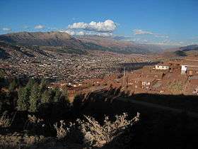

 Pachatusan above the sanctuary Señor de Huanca