Patallaqta
For another archaeological site called Llaqtapata, see
Llaqtapata.
Patallaqta (Quechua pata elevated place / above, at the top / edge, bank (of a river), shore, llaqta place (village, town, city, country, nation),[1] "settlement on a platform"[2] pronounced "pahta-yakta", hispanicized spelling Patallacta), Llaqtapata (Llactapata)[3] or Q'inti Marka (Quechua q'inti hummingbird, marka village, "hummingbird village", also spelled 'Q'ente Marka') is an archaeological site in Peru located in the Cusco Region, Urubamba Province, Machupicchu District. It is situated southeast of the site Machu Picchu, at the confluence of the rivers Kusichaka and Willkanuta on a mountain named Patallaqta.[4]
On his way to discover Machu Picchu (at: 13°13′57″S 72°25′30″W / 13.2325095°S 72.424922°W / -13.2325095; -72.424922) Hiram Bingham, discoverer of Machu Picchu and many other Incan sites, passed Patallaqta,[5] sometimes given the name of Llaqtapata as evidenced by the photograph of a sign from a check-point along the Inca trail.[6] His associate Mr. Herman Tucker reported that the name of the town was Patallacta containing about one hundred houses. Above it were several important sites including Wayllapampa.[7] This site is located 1.5 km (1 mi) from the start of the "Classic Inca Trail" which begins at Km 88.[8]
This site housed a large number of occupants, including travellers and soldiers who manned the nearby "hill fort" of Willkaraqay, and a shrine with rounded walls known as Pulpituyuq that had religious and ceremonial functions.[9]
Patallaqta was burned by Manco Inca Yupanqui, who destroyed a number of settlements along the Inca road system during his retreat from Cusco in 1536 to discourage Spanish pursuit. In part due to these efforts, the Spanish never discovered the Inca Trail to Machu Picchu or any of its settlements.[10]
Gallery
-
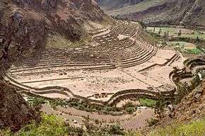
Patallaqta viewed from above on the Inca trail near Willkaraqay
-
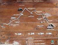
Sign at check-point near Willkaraqay identifying Patallaqta as Llaqtapata
-
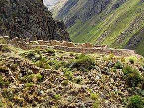
Willkaraqay ruins on hill above Patallaqta
-
Workers are dwarfed by terraces, which are in turn dwarfed by the surrounding mountains
See also
References
- ↑ Teofilo Laime Ajacopa, Diccionario Bilingüe Iskay simipi yuyayk'ancha, La Paz, 2007 (Quechua-Spanish dictionary)
- ↑ Diccionario Quechua - Español - Quechua, Academía Mayor de la Lengua Quechua, Gobierno Regional Cusco, Cusco 2005 (Quechua-Spanish dictionary): see Patallaqta
- ↑ mincetur.gob.pe
- ↑ escale.minedu.gob.pe - UGEL map of the Urubamba Province (Cusco Region)
- ↑ Online version of "Inca Land - Explorations in the Highlands of Peru" by Hiram Bingham
- ↑ "Chapter X - Searching for the Last Inca Capital". Inca Land - Explorations in the Highlands of Peru - by Hiram Bingham. Retrieved 2011-06-27.
- ↑ Lost City of the Incas. by Hiram Bingham. 1952. The Orion Publishing Group Ltd, Orion House. page 164. ISBN 0-297-60759-6
- ↑ Cuzco Region Machu Picchu / Inca Trail. International Travel Maps. A Division of ITMB Publishing Ltd. 2006.
- ↑ Explore the Inca Trail. Rucksack Readers. 2006.
- ↑ Noland, David (2001) [2001-02-01]. Trekking. W. W. Norton & Company. ISBN 978-0-393-32072-5.
|
|---|
|
- Acaray
- Amaru Marka Wasi
- Arhuaturo
- Asana
- Asiru Phat'jata
- Aspero
- Awila Qhincha Mach'ay
- Awkin Punta
- Awkillu Waqra
- Awkimarka (Apurímac)
- Awkimarka (Huánuco)
- Awqa Punta
- Aya Muqu
- Ayamach'ay
- Ayawayq'u
- Azángaro
- Baths of Boza
- Bandurria
- Buena Vista
- Cahuachi
- Cajamarquilla
- Cao Viejo
- Carajía
- Caral
- Caves of Sumbay
- Cerro Baúl
- Cerro Pátapo
- Cerro Trinidad
- Chakamarka
- Chan Chan
- Chankillo
- Chauchilla Cemetery
- Chavín de Huantar
- Chawaytiri
- Chichakuri
- Chipaw Marka
- Chuqik'iraw
- Chuqik'iraw Pukyu
- Chuqi Pukyu
- Churajón
- Chuya
- Ch'iqullu
- Cota Coca
- Cumbe Mayo
- El Brujo
- El Cañoncillo
- El Ingenio
- El Paraíso
- Garagay
- Gran Pajáten
- Gran Vilaya
- Guitarrero Cave
- Hatun Rumiyuq
- Hatun Mach'ay
- Hatun Misapata
- Hatun Uchku
- Hatun Usnu
- Hatunmarka
- Hunqupampa
- Inka Mach'ay
- Inka Raqay, Apurímac
- Inka Raqay, Ayacucho
- Inka Tampu, Cajamarca
- Inka Tampu, Huayopata
- Inka Tampu, Vilcabamba
- Inka Tunuwiri
- Inka Uyu
- Inka Wasi, Ayacucho
- Inka Wasi, Huancavelica
- Inka Wasi, Lima
- Inkapintay
- Inkill Tampu
- Inti Punku
- Inti Watana, Ayacucho
- Inti Watana, Calca
- Inti Watana, Urubamba
- Intikancha
- Intini Uyu Pata
- Intipa Ñawin
- Intiyuq K'uchu
- Iskuqucha
- Isuq
- Jinkiori
- Jisk'a Iru Muqu
- Kanichi
- Killa Mach'ay
- Killa Rumi
- Killarumiyuq
- Kiswar
- Kotosh
- Kuelap
- Kukuli
- Kuntur Wasi
- Kunturmarka, Ayacucho
- Kunturmarka, Pasco
- Kuntur Qaqa
- Kuntuyuq
- Kusichaka valley
- Kutimpu
- Khichuqaqa
- Khuchi Mach'ay
- K'allapayuq Urqu
- K'anamarka
- K'ipakhara
- Laguna de las Momias
- Lawriqucha
- Layzón
- Llamachayuq
- Llamachayuq Qaqa
- Llamayuq
- Llamuqa
- Llaqta Qulluy, Acoria
- Llaqta Qulluy, Conayca
- Llaqta Qulluy, Tayacaja
- Llaqta Qulluy, Vilca
- Llaqtan
- Llaqtapata
- Machu Pikchu
- Machu Pirqa
- Machu Pitumarka
- Machu Q'inti
- Machu Qullqa
- Mameria
- Maray Qalla
- Marayniyuq
- Markahirka
- Markansaya
- Markapukyu
- Markawamachuku
- Marpa
- Mawk'allaqta, Castilla
- Mawk'allaqta, Espinar
- Mawk'allaqta, La Unión
- Mawk'allaqta, Melgar
- Mawk'allaqta, Paruro
- Mawk'allaqta, Sandia
- Mawk'ataray
- Mayqu Amaya
- Mazur
- Mikulla
- Millka
- Miraflores
- Mirq'imarka
- Miyu Pampa
- Mulinuyuq
- Mullu Q'awa
- Mulluq'u
- Muray
- Muyu Muyu
- Muyu Urqu
- Muyuq Marka
- Nazca Lines
- Nina Kiru
- Ninamarka
- Ñawpallaqta, Huanca Sancos
- Ñawpallaqta, Fajardo
- Ñawpallaqta, Lucanas
- Ñust'a Hisp'ana
- Pacatnamu
- Pachakamaq
- Pachatusan
- Paiján
- Pañamarka
- Paracas Candelabra
- Paraxra
- Patallaqta
- Phiruru
- Pikillaqta
- Pikimach'ay
- Pilluchu
- Pinkuylluna
- Pirqa Pirqa, La Libertad
- Pirqa Pirqa, Lima
- Pirwalla
- Pirwayuq
- P'isaq
- Puka Pukara
- Puka Tampu
- Puka Urqu
- Pukara, Coporaque
- Pukara, Fajardo
- Pukara, Puno
- Pukara, Vilcas Huamán
- Pukarani
- Pumamarka, San Sebastián
- Pumamarka, Urubamba
- Pumaq Hirka
- Pumawasi
- Punkuri
- Puqin Kancha
- Puruchuco
- Purum Llaqta, Cheto
- Purum Llaqta, Soloco
- Pusharo
- Pusuquy Pata
- Phuyupatamarka
- Qaqapatan
- Qillqatani
- Quchapata
- Qillqa
- Qillqay Mach'ay
- Quchapampa
- Quiaca
- Qullqanpata
- Qullqapampa
- Qulu Qulu
- Qunchamarka
- Qunchupata
- Quri Winchus
- Qurikancha
- Qurimarka, Apurímac
- Qurimarka, Cusco
- Quriwayrachina, Anta
- Quriwayrachina, Ayacucho
- Quriwayrachina, La Convención
- Quyllur
- Q'arachupa
- Qasa Pata
- Qhapaq Kancha
- Q'illaywasin
- Q'inqu
- Q'inq'u
- Raimondi Stele
- Raqch'i
- Revash
- Rumiqullqa
- Rumiwasi
- Runayuq
- Runkuraqay
- Saksaywaman
- Sara Sara
- Sayaqmarka
- Sayhuite
- Sechin
- Sillustani
- Sipán
- Suntur
- Susupillu
- Tambo Totem
- Tampu Mach'ay, Cusco
- Tampu Mach'ay, Huancavelica
- Tampukancha
- Tanqa Tanqa
- Tantarica
- Taqrachullu
- Tarawasi
- Tarmatampu
- Templo del Zorro
- The Toads of Wiraqucha
- Tikra
- Tinyaq
- Tipón
- Titiqaqa
- Toquepala Caves
- Toro Muerto
- Trinchera
- Túcume
- Tunanmarka
- Tunay Q'asa
- Tupu Inka
- T'akaq
- T'uqu T'uquyuq
- Uchkus Inkañan
- Ullantaytampu
- Urpish
- Uskallaqta
- Usnu, Ayacucho
- Usnu, Huánuco
- Usnu Muqu
- Usqunta
- Uyu Uyu
- Venado cautivo
- Ventanillas de Otuzco
- Ventarron
- Vitcos
- Wak'a del Dragón
- Wak'a Wallamarka
- Wak'a de la Luna
- Wak'a del Sol
- Wak'a of San Marcos
- Wak'a of Santa Ana
- Wak'a Prieta
- Wak'a Pukllana
- Wallpayunka
- Waman Pirqa
- Wamanilla
- Wamanmarka, Chumbivilcas
- Wamanmarka, La Convención
- Wamanmarka, Lima
- Wamp'uy
- Wanakawri, Cusco
- Wanakawri, Huánuco
- Wanqaran
- Wanuku Pampa
- Waqlamarka
- Waqramarka
- Waqra Pukara
- Waqutu
- Warahirka
- Waraqayuq
- Waraqu Urqu
- Warawtampu
- Wari ruins
- Wari Willka
- Waruq
- Wat'a, Cusco
- Wat'a, Huánuco
- Wayna Pikchu
- Wayna Q'inti
- Wayna Tawqaray
- Wayra Punku
- Wichama
- Wichqana
- Wich'un
- Wila Wilani
- Willka
- Willkapampa
- Willkaraqay
- Willkawaman
- Willkawayin
- Wiñaw
- Wiñay Wayna
- Wiraqucha Pirqa
- Wiraquchapampa
- Yanaca
- Yanaqi - Qillqamarka
- Yaynu
- Yuraq Mach'ay
|