Huajramarca
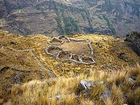
 The site Huajramarca on top of the mountain Huajramarca | |
| Location | Peru |
|---|---|
| Region | Ancash Region |
| Coordinates | 9°10′32″S 77°26′00″W / 9.1754411°S 77.4332291°WCoordinates: 9°10′32″S 77°26′00″W / 9.1754411°S 77.4332291°W |
| Height | 4,150 metres (13,615 ft) |
Huajramarca or Huacramarka (possibly from Quechua Waqramarka, waqra horn, marka village[1]) is an archaeological site on a mountain of the same name in Peru. It is located in the Ancash Region, Asunción Province, Chacas District. Huajramarca lies southeast of the mountain Yanarahu at the Putaqa River, near the village Wayin (Huallin). The ruins are situated on top of the mountain Huajramarca at a height of 4,150 metres (13,615 ft).[2][3]
Images
-

Huajramarca with the Cordillera Blanca and the mountains Hualcán and Yanarahu in the background
References
- ↑ Teofilo Laime Ajacopa, Diccionario Bilingüe Iskay simipi yuyayk'ancha, La Paz, 2007 (Quechua-Spanish dictionary): waqra - s. Cuerno. marka - s. Pueblo o aldea.
- ↑ Rafael Vega-Centeno, El Proyecto de Investigación Arqueológica Huacramarca. Resultados preliminares. investigaciones sociales Año XII N° 21, pp. 49-75 [unmsm / iihs, Lima, 2008] (in Spanish)
- ↑ escale.minedu.gob.pe - UGEL map of the Asunción Province (Ancash Region) showing the mountain Huajramarca (unnamed) near the village Wayin (Huallin) and the Putaqa River (Putaca)
This article is issued from Wikipedia - version of the 10/10/2016. The text is available under the Creative Commons Attribution/Share Alike but additional terms may apply for the media files.