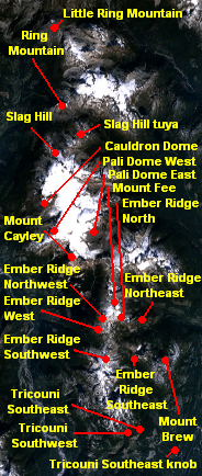
Pali Dome
| Pali Dome | |
|---|---|
 Mount Cayley volcanic field | |
| Highest point | |
| Listing | |
| Coordinates | 50°8′13″N 123°18′25″W / 50.13694°N 123.30694°W |
| Geography | |
| Location | British Columbia, Canada |
| Parent range | Pacific Ranges |
| Geology | |
| Mountain type | Subglacial volcano |
| Volcanic arc/belt |
Canadian Cascade Arc Garibaldi Volcanic Belt |
| Last eruption | Pleistocene/Holocene |
Pali Dome is a subglacial volcano in the Pacific Ranges of the Coast Mountains in southwestern British Columbia, Canada. It is part of the Mount Cayley volcanic field and its elevation is 2,250 m (7,380 ft).[1] For the past 2 million years, the Mount Cayley volcanic field has had interactions between ice and lava which have created some unique landforms and an in-ice drainage system.[2]"Pali" comes from the Hawaiian word that means cliff or steep hill, while dome refers to the lava dome, which is when doughy lava flows from a volcanic vent which is usually rounded and flat on top.[3]
One of the last known eruptions of the Pali Dome was over 10,000 years ago.[4]
See also
- List of volcanoes in Canada
- Mount Cayley volcanic field
- Volcanism of Canada
- Volcanism of Western Canada
References
- ↑ "Pali Dome- Climbing, Hiking, & Mountaineering". Mountain Forecast. Retrieved 15 September 2016.
- ↑ Andrews, Graham D. M., Lucy Porritt, and J. K. Russell. "Quaternary Subglacial And Explosive Volcanism In The Canadian Cascade Arc (Sea-To-Sky Corridor), British Columbia." GSA Field Guide 38.(2014): 125-167. GeoRef. Web. 15 Sept. 2016.
- ↑ "Volcano Glossary". Midju. tripod.com. Retrieved 15 September 2016.
- ↑ "Catalogue of Canadian volcanoes: Pali Dome East". web.archive.org. Natural Resources Canada. 2009-03-10. Retrieved 2016-10-25.
External links
This article is issued from Wikipedia - version of the 10/28/2016. The text is available under the Creative Commons Attribution/Share Alike but additional terms may apply for the media files.