Pyroclastic Peak
| Pyroclastic Peak | |
|---|---|
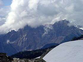 South face of Pyroclastic Peak | |
| Highest point | |
| Elevation | 2,349 m (7,707 ft) |
| Prominence | 145 m (476 ft) |
| Coordinates | 50°06′51.8″N 123°17′34.1″W / 50.114389°N 123.292806°WCoordinates: 50°06′51.8″N 123°17′34.1″W / 50.114389°N 123.292806°W |
| Geography | |
| Location | British Columbia, Canada |
| Parent range | Pacific Ranges |
| Topo map | NTS 92J/03 |
| Geology | |
| Age of rock | Pleistocene |
| Mountain type | Stratovolcano |
| Volcanic arc/belt | |
| Last eruption | Pleistocene |
| Climbing | |
| First ascent | 1971 R. Chicoine; F. Douglas; R. Wyborn[1] |
Pyroclastic Peak is the second highest of the five named volcanic peaks immediately south of Mount Cayley in British Columbia, Canada. It is steep and rotten and is located 12 km (7 mi) southwest of Callaghan Lake and 24 km (15 mi) west of Whistler. It is part of the Pacific Ring of Fire that includes over 160 active volcanoes.
On the south ridge of Pyroclastic Peak is a feature known as The Vulcan's Thumb which remains unclimbed[1] because of the looseness of the rock.
See also
- Cascade Volcanoes
- Mount Cayley
- Garibaldi Volcanic Belt
- Volcanism of Canada
- Volcanism of Western Canada
- List of volcanoes in Canada
References
- 1 2 "Pyroclastic Peak". Bivouac.com. Retrieved 2007-05-01.
This article is issued from Wikipedia - version of the 12/20/2012. The text is available under the Creative Commons Attribution/Share Alike but additional terms may apply for the media files.