Mount Price (British Columbia)
| Mount Price | |
|---|---|
|
Red Mountain Clinker Mountain | |
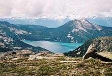
 Mount Price and one of the Battleship Islands reflected in the clear water of Garibaldi Lake | |
| Highest point | |
| Elevation | 2,052 m (6,732 ft) |
| Prominence | 402 m (1,319 ft) |
| Coordinates | 49°54′59.61″N 123°02′04.05″W / 49.9165583°N 123.0344583°WCoordinates: 49°54′59.61″N 123°02′04.05″W / 49.9165583°N 123.0344583°W |
| Geography | |
 Mount Price | |
| Parent range | Garibaldi Ranges |
| Topo map | NTS 92J/12 |
| Geology | |
| Mountain type | Stratovolcano |
| Volcanic arc/belt | |
| Last eruption | ~10,000 years ago[1] |
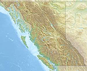
Mount Price is a small stratovolcano in the Garibaldi Ranges of the Pacific Ranges in southwestern British Columbia, Canada. It is located 10 km (6.2 mi) southeast of the abandoned settlement of Garibaldi above the eastern flank of the Cheakamus River valley. With a summit elevation of 2,052 m (6,732 ft) and a topographic prominence of 402 m (1,319 ft), it rises above the surrounding landscape on the western shore of Garibaldi Lake. A large provincial park surrounds Mount Price and other volcanoes in its vicinity.
Its northern and western flanks are overlapped by smaller volcanic edifices, such as Clinker Peak, which was the source for two thick lava flows about 10,000 years ago that ponded against glacial ice. These volcanoes were formed by volcanic eruptions from secondary vents rather than individual ones. As a result, Clinker Peak and other flank volcanoes are interpreted to be part of Mount Price.
The mountain is associated with a small group of related volcanoes called the Garibaldi Lake volcanic field. This forms part of the larger Garibaldi Volcanic Belt, a north-south trending volcanic zone that represents a portion of the Canadian Cascade Arc. Mount Price began its formation 1.2 million years ago and activity continued intermittently until about 10,000 years ago. Even though the mountain has not erupted since the early Holocene epoch, it could erupt again, which would potentially pose danger to the nearby populace. If this were to happen, relief efforts would be quickly organized. Teams such as the Interagency Volcanic Event Notification Plan (IVENP) are prepared to notify people threatened by volcanic eruptions in Canada.
Geology
Mount Price is one of the three principal volcanoes in the southern segment of the Garibaldi Volcanic Belt. In contrast to most stratovolcanoes in Canada, Mount Price has a nearly symmetrical structure. It is one of the several Garibaldi Belt volcanoes that have been active in the Quaternary period.[2] Clinker Peak, a breached volcanic crater on its western flank, was formed during a period of volcanic activity about 10,000 years ago.[1][2] Oxidation of Price's volcanic rocks has given the mountain a red colour.[3]
Like other volcanoes in the Garibaldi Volcanic Belt, Mount Price formed as a result of subduction zone volcanism. As the Juan de Fuca Plate subducts under the North American Plate at the Cascadia subduction zone, it forms volcanoes and volcanic eruptions.[4] Unlike most subduction zones worldwide, there is no deep oceanic trench present along the continental margin in Cascadia. There is also very little seismic evidence that the Juan de Fuca Plate is actively subducting. As a result, the existence of active volcanism in the Cascade Volcanic Arc is the best evidence for ongoing subduction. However, volcanic activity along the Cascade Arc has been declining over the last few million years. The probable explanation lies in the rate of convergence between the Juan de Fuca and North American plates. These two tectonic plates currently converge at a rate of 3 cm (1.2 in) to 4 cm (1.6 in) per year, only about half the rate of convergence from seven million years ago. This slowed convergence likely accounts for reduced seismicity and lack of an oceanic trench.[2]
Volcanic history
At least three phases of eruptive activity have been identified at Mount Price.[2] The first event 1.2 million years ago deposited hornblende andesite lava and pyroclastic rocks on the floor of a cirque-like basin after an Early Pleistocene glacial event.[2][5] The Black Tusk, a deeply dissected stratovolcano 5 km (3.1 mi) north of Mount Price, was also active during this period. Because older volcanic events have not been identified in the Garibaldi area, this is the oldest known eruptive period in the Garibaldi Lake volcanic field.[5]

During the Middle Pleistocene about 300,000 years ago, volcanism shifted westward and constructed the nearly symmetrical stratovolcano of Mount Price. Episodic eruptions produced andesite and dacite lavas, as well as pyroclastic flows from Peléan activity. Later, the volcano was overridden by the Cordilleran Ice Sheet, which covered a large area of North America during glacial periods of the Quaternary.[2]
After the Cordilleran Ice Sheet had retreated from higher elevations, andesite eruptions from a satellite vent created a small lava dome on Price's northern flank.[5] Possibly contemporaneous volcanism occurred at Clinker Peak about 10,000 years ago with the eruption of two hornblende-biotite andesite lava flows.[1][2] They are both at least 300 m (980 ft) thick and 6 km (3.7 mi) long, extending to the northwest and southwest.[2][5] The unusually large thickness of these lava flows is from them ponding and cooling against the Cordilleran Ice Sheet when it still filled valleys at lower elevations.[5] A prominent feature of these lava flows are the levees that demarcate the lava channels. The northwest lava flow forms a volcanic dam known as The Barrier.[1] This retains the Garibaldi Lake system and has been the source for two large landslides in the past. The most recent major landslide in 1855-1856 resulted from failure along vertical rock fractures.[6] It travelled 6 km (3.7 mi) down Rubble Creek to the Cheakamus valley, depositing 30,000,000 m3 (1.1×10⁹ cu ft) of rock.[6][7] The southwest lava flow forms a mountain ridge called Clinker Ridge.[1]
In contrast to Mount Cayley and Mount Meager, no hot springs are known in the Garibaldi area. However, there is evidence of anomalously high heat flow in Table Meadows near the southern flank of Mount Price. This indicates that magmatic heat is still present under the Garibaldi area and it is probably related to recent volcanic activity.[8]
Human history
Naming
Mount Price has had at least two names throughout its history. It was originally named Red Mountain for its red appearance, but the date when this name was adopted has not been cited.[9] Another peak west of Overlord Mountain was identified as Red Mountain on a 1923 sketch by Canadian mountaineer Neal M. Carter.[10][11] To avoid confusion, the name of this mountain was changed to Fissile Peak on September 2, 1930 for its fissility.[9][10]
In 1927, Canadian volcanologist William Henry Mathews (1919–2003) identified Mount Price as Clinker Mountain in articles and journals. The name Mount Price was adopted on September 2, 1930 after a committee of the Garibaldi Park Board was set up to deal with nomenclature. It was requested that the Geographic Board of Canada to adopt Mount Price for this mountain after Thomas E. Price, a former mountaineer and engineer of the Canadian Pacific Railway.[9] Clinker Peak and Clinker Ridge were both officially named on September 12, 1972 to retain Price's earlier name Clinker Mountain.[12][13]
Protection and monitoring
The volcano and its eruptive products are protected in Garibaldi Provincial Park. Founded in 1927 as a Class A provincial park, this wilderness park covers an area of 194,650 ha (481,000 acres). Lying within its boundaries are a number of other volcanoes, such as Mount Garibaldi and The Black Tusk. Located 70 km (43 mi) north of Vancouver in the glaciated Coast Mountains, Garibaldi Provincial Park contains diverse vegetation, iridescent waters and a rich geological history. The park also has abundant wildlife, such as squirrels, chipmunks, grey jays and flickers. Garibaldi Provincial Park is named after Mount Garibaldi, which is in turn named after the Italian patriot and soldier Giuseppe Garibaldi.[14]
Like other volcanoes in the Garibaldi Lake volcanic field, Mount Price is not monitored closely enough by the Geological Survey of Canada to ascertain how active its magma system is. The Canadian National Seismograph Network has been established to monitor earthquakes throughout Canada, but it is too far away to provide an accurate indication of activity under the mountain. It may sense an increase in seismic activity if Price becomes highly restless, but this may only provide a warning for a large eruption; the system might detect activity only once the volcano has started erupting.[15] If Price were to erupt, mechanisms exist to orchestrate relief efforts. The Interagency Volcanic Event Notification Plan (IVENP) was created to outline the notification procedure of some of the main agencies that would respond to an erupting volcano in Canada, an eruption close to the Canada–United States border or any eruption that would affect Canada.[16]
Volcanic hazards
At least 63 volcanic events have occurred in the Garibaldi Lake volcanic field in the past 1.3 million years.[17] Since the early Holocene epoch, there has been no eruptive activity.[2] Future eruptions of Mount Price will probably be similar in character to those that have occurred throughout its 1.2 million year eruptive history.[1][5] The minimum annual probability of an eruption occurring in Canada is about one every 200 years; for an effusive eruption the probability is about one every 220 years and for a large explosive eruption the probability decreases to about one every 3,333 years. This indicates that an eruption in the foreseeable future is more likely to be characterized by fluid lava rather than major explosivity.[18] However, the majority of these effusive eruptions occur in the Northern Cordilleran Volcanic Province of northwestern British Columbia and central Yukon, which is the most active volcanic zone in Canada.[2][19] In the Garibaldi Volcanic Belt, eruptions occur less often, but it is the site of Canada's most explosive volcanism.[4] The change in eruptive style between the two volcanic zones is caused by the different tectonic processes that formed them. Nevertheless, the possibility of passive lava eruptions occurring in the Garibaldi Volcanic Belt cannot be ruled out.[2]
Effects
Mount Price is near the highly populated southwest corner of British Columbia, indicating that it poses a serious threat to the surrounding area.[1][4] Even though Plinian eruptions have not been identified at Mount Price, Peléan eruptions can also produce large amounts of volcanic ash that could significantly affect the nearby communities of Whistler and Squamish.[1] Mount Price is also situated in the immediate proximity of a major air traffic route.[20] Volcanic ash reduces visibility and can cause jet engine failure, as well as damage to other aircraft systems.[21] Peléan eruptions may cause short and long term water supply problems for the city of Vancouver and most of the Lower Mainland. The catchment area for the Greater Vancouver watershed is downwind from Mount Price. An eruption producing floods and lahars could destroy parts of the Sea to Sky Highway, threaten communities such as Brackendale and endanger water supplies from Pitt Lake. Fisheries on the Pitt River would also be at risk. These volcanic hazards become more serious as the Lower Mainland grows in population.[1] More than 60% of British Columbia's people live in the Lower Mainland and it is one of Canada's most rapidly changing ecoregions.[22][23] This is mostly because of its increasing population and economic development.[23]

Because andesite is the main type of lava erupted from Mount Price, lava flows are a low to moderate hazard.[1] Andesite lava is intermediate in silica content, indicating that it has a higher viscosity than basaltic lava, but less viscous than dacite and rhyolite lava. As a result, andesite lava flows typically move slower than basaltic lava flows and are less likely to travel far from their source. Dacite and rhyolite lavas are normally too viscous to flow far from a volcanic vent, resulting in the formation of lava domes.[24] An exception is the 15 km (9.3 mi) long Ring Creek dacite lava flow from Opal Cone on the southeastern flank of Mount Garibaldi, a length that is normally attained by basaltic lava flows.[1]
Concerns about The Barrier's instability due to volcanic, tectonic or heavy rainfall activity prompted the provincial government to declare the area immediately below it unsafe for human habitation in 1980.[6] This led to the evacuation of the small resort village of Garibaldi nearby and the relocation of residents to new recreational subdivisions away from the hazard zone.[1][6] Should The Barrier completely collapse, Garibaldi Lake would be entirely released and downstream damage in the Cheakamus and Squamish rivers would be considerable, including major damage to the town of Squamish and possibly an impact-wave on the waters of Howe Sound that would reach Vancouver Island.[6] The landslide area is referred to as the Barrier Civil Defence Zone. Although landslides are unlikely to happen in the near future, warning signs are posted at the zone to make visitors aware of the potential danger and to minimize the chance of fatalities in the event of a slide. For safety reasons, BC Parks recommends visitors not to camp, stop or linger in the Barrier Civil Defence Zone.[14]
See also
- Bridge River Cones
- List of volcanoes in Canada
- List of Cascade volcanoes
- Mount Cayley volcanic field
- Squamish volcanic field
- Volcanology of Western Canada
References
- 1 2 3 4 5 6 7 8 9 10 11 12 "Garibaldi volcanic belt: Garibaldi Lake volcanic field". Catalogue of Canadian volcanoes. Natural Resources Canada. 2009-04-01. Archived from the original on May 13, 2008. Retrieved 2011-01-21.
- 1 2 3 4 5 6 7 8 9 10 11 Wood, Charles A.; Kienle, Jürgen (2001). Volcanoes of North America: United States and Canada. Cambridge, England: Cambridge University Press. pp. 113, 114, 143, 144, 148. ISBN 0-521-43811-X.
- ↑ Smellie, J. L.; Chapman, M. G. (2002). Volcano-Ice Interaction on Earth and Mars. Geological Society of London. p. 202. ISBN 1-86239-121-1.
- 1 2 3 "Garibaldi volcanic belt". Catalogue of Canadian volcanoes. Natural Resources Canada. 2009-04-02. Archived from the original on June 15, 2008. Retrieved 2011-01-21.
- 1 2 3 4 5 6 Read, Peter B. (1990). "Late Cenozoic Volcanism in the Mount Garibaldi and Garibaldi Lake Volcanic Fields, Garibaldi Volcanic Belt, Southwestern British Columbia". Articles. St. John's, Newfoundland: Geological Association of Canada. 17 (3): 172, 173. ISSN 1911-4850.
- 1 2 3 4 5 Evans, S.G.; Savigny, K.W. (1994). "Landslides in the Vancouver-Fraser Valley-Whistler region". Geology and Geological Hazards of the Vancouver Region, Southwestern British Columbia. Ottawa, Ontario: Natural Resources Canada. pp. 268, 270. ISBN 0-660-15784-5.
- ↑ "Where do landslides occur?". Government of British Columbia. Retrieved 2012-01-21.
- ↑ Woodsworth, Glenn J. (April 2003). "Geology and Geothermal Potantial of the AWA Claim Group, Squamish, British Columbia". Vancouver, British Columbia: Gold Commissioner: 10.
- 1 2 3 "Mount Price". BC Geographical Names. Government of British Columbia. Retrieved 2011-01-15.
- 1 2 "Fissile Peak". BC Geographical Names. Government of British Columbia. Retrieved 2012-11-13.
- ↑ Scott, Chic (2002). Pushing the Limits: The Story of Canadian Mountaineering. Calgary, Alberta: Rocky Mountain Books. p. 122. ISBN 0-921102-59-3.
- ↑ "Clinker Peak". BC Geographical Names. Government of British Columbia. Retrieved 2011-01-15.
- ↑ "Clinker Ridge". BC Geographical Names. Government of British Columbia. Retrieved 2011-01-16.
- 1 2 "Garibaldi Provincial Park". BC Parks. Retrieved 2012-01-19.
- ↑ "Monitoring volcanoes". Volcanoes of Canada. Natural Resources Canada. 2009-02-26. Archived from the original on June 8, 2008. Retrieved 2012-01-20.
- ↑ "Interagency Volcanic Event Notification Plan (IVENP)". Volcanoes of Canada. Natural Resources Canada. 2008-06-04. Archived from the original on February 14, 2009. Retrieved 2012-01-20.
- ↑ Bobrowsky, Peter (1992). "Geologic Hazards in British Columbia" (PDF). Volcanic Hazards. Victoria, British Columbia: Geologic Hazards '91 Workshop: 54. ISSN 0835-3530. Retrieved 2012-01-22.
- ↑ Stasiuk, Mark V.; Hickson, Catherine J.; Mulder, Taimi (2003). "Natural Hazards". The Vulnerability of Canada to Volcanic Hazards. 28. Springer Netherlands: 563. ISSN 0921-030X.
- ↑ "Stikine volcanic belt". Catalogue of Canadian volcanoes. Natural Resources Canada. 2008-02-13. Archived from the original on June 8, 2009. Retrieved 2012-01-23.
- ↑ "Volcanic hazards". Volcanoes of Canada. Natural Resources Canada. 2009-04-02. Archived from the original on February 2, 2009. Retrieved 2012-01-21.
- ↑ Neal, Christina A.; Casadevall, Thomas J.; Miller, Thomas P.; Hendley II, James W.; Stauffer, Peter H. (2004-10-14). "Volcanic Ash–Danger to Aircraft in the North Pacific". United States Geological Survey. Retrieved 2012-01-21.
- ↑ "Welcome of the Lower Mainland Region". Government of British Columbia. Retrieved 2012-11-24.
- 1 2 Evans, James (2011). "B.C.'s Lower Mainland". Statistics Canada: 210.
- ↑ "Magma, Lava, Lava Flows, Lava Lakes, etc.". United States Geological Survey. 2009-07-02. Retrieved 2012-01-21.
External links
| Wikimedia Commons has media related to Mount Price. |
- "Mount Price". Bivouac.com. Retrieved 2012-01-21.
- "Mount Price". Geographical Names Data Base. Natural Resources Canada. Retrieved 2012-01-21.
- "Clinker Peak". Bivouac.com. Retrieved 2012-01-21.
- "Clinker Peak". Geographical Names Data Base. Natural Resources Canada. Retrieved 2012-01-21.