Papakolea Beach
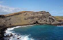
Papakōlea Beach (also known as Green Sand Beach or Mahana Beach[1]) is a green sand beach located near South Point, in the Kaʻū district of the island of Hawaiʻi. One of only four green sand beaches in the world, the others being Talofofo Beach, Guam; Punta Cormorant on Floreana Island in the Galapagos Islands; and Hornindalsvatnet, Norway. It gets its distinctive coloring from the mineral olivine, found in the enclosing cinder cone.
Characteristics


Papakōlea Beach is located in a bay half circled by Puʻu Mahana, a cinder cone formed over 49,000 years ago[2] and associated with the southwest rift of Mauna Loa. Since its last eruption, the cinder cone has partially collapsed and been partially eroded by the ocean. The beach is sometimes named after the cinder cone, and sometimes after the area of land called Papakōlea, which comes from papa kōlea, which means plover flats in the Hawaiian language.[3] Papakōlea is the area near the crater[4] where Pacific golden plovers (Pluvialis fulva) are sometimes seen in winter.[5]
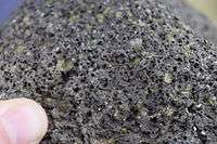
The cinder cone is rich in olivine, a silicate mineral containing iron and magnesium, also known as peridot when of gem quality. Olivine is a common mineral component of Hawaiian lavas and one of the first crystals to form as magma cools.[6] Olivine is locally known as "Hawaiian Diamond" and is notably found in Oʻahu's famous Diamond Head landmark.[7] The source of the green coloration of the beach sands is due to the olivine crystals which are winnowed from the eroding headland by the action of the sea. Olivine, being denser and tougher than the ash fragments, glass and black pyroxene of the rest of the rocks and lava flows, tends to accumulate on the beach whereas the usual volcanic sand is swept out to sea.[8][9]
Although these crystals are eventually broken down by weathering and chemical action (olivine is decomposed by carbon dioxide and water,[10] faster as grain size decreases) and washed away, the constant erosion of the cinder cone ensures a steady supply of sand for the foreseeable future—eventually, however, the supply will run out and the beach will look like any other.[11]
The formation of the cinder cone is currently a point of contention, with some arguing that lava flowing into the sea was suddenly cooled, forming an edifice on the coastline (a literal cone) and others noting that the cone was most likely too far away from the ocean at the time of formation to make such an event possible.[2] Regardless of how it was formed according to the United States Geological Survey, the last lava flow in the area ended over 10,000 years ago, making the area one of the more stable features in the geologically turbulent Kaʻū region.[12] As such, the geologic history of the site can be seen in the rock surrounding the beach and bay, which are not subject to erosion and thus display geologic layers formed by previous eruptions, lava flows, and other volcanic events.[13] In addition, the current patterns of erosion can be seen first-hand, as only the portions at the bottom of the cinder cone collapse have been subject to the waves and turned into green sand; the remaining portions appear gray.[14]


Access


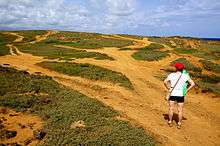
The beach is located at coordinates 18°56′11″N 155°38′47″W / 18.936379°N 155.646315°WCoordinates: 18°56′11″N 155°38′47″W / 18.936379°N 155.646315°W, about 3 miles (5 km) east of Ka Lae (known as South Point) on the island of Hawaiʻi.[15] It is surrounded by pasturelands and is only accessible by foot. The paths are rugged (due to both vehicular traffic and erosion) and the land owner, the Department of Hawaiian Home Lands, has since restricted vehicular traffic in the area.[16] To actually reach the beach, an additional climb down the cinder cone is required.[16][17]
References
- ↑ U.S. Geological Survey Geographic Names Information System: Mahana Beach
- 1 2 "The Origins of Puʻu Mahana are not crystal clear". Hawaiian Volcano Observatory. USGS. 2005-10-27. Retrieved 2008-01-22.
- ↑ Mary Kawena Pukui and Elbert (2004). "lookup of Papakolea". on Place Names of Hawai'i. Ulukau, the Hawaiian Electronic Library, University of Hawaii. Retrieved 2010-04-15.
- ↑ U.S. Geological Survey Geographic Names Information System: Papakōlea
- ↑ Mary Kawena Pukui and Elbert (2003). "lookup of plover". on Hawaiian dictionary. Ulukau, the Hawaiian Electronic Library, University of Hawaii. Retrieved 2010-03-01.
- ↑ Lucas, Carolyn (2006-06-13). "What makes sand... A look at the science behind the scenic". West Hawaii Today. Retrieved 2008-01-23.
- ↑ Tilling, Robert I.; Christina Heliker; Thomas L. Wright (1987). "Eruptive Style: Powerful but Usually Benign". Eruptions of Hawaiian Volcanoes: Past, Present, and Future. USGS. Retrieved 2008-01-22.
- ↑ "Green Sand". Coastal Geology of the Parks. USGS. 2004. Retrieved 2008-01-22.
- ↑ Mattox, Steve. "How was the green sand beach on the Big Island, Hawaii formed?". Volcano World. University of North Dakota. Retrieved 2008-01-22.
- ↑ Olivine#Weathering
- ↑ "Green Sand Beach - Getting There". Coastal Geology of the Parks. Reston, VA & Denver, CO, USA: USGS. Retrieved April 26, 2012. External link in
|work=(help) - ↑ "Natural hazards in the Kaʻu District". Hawaiian Volcano Observatory. USGS. 1998-03-05. Retrieved 2008-01-23.
- ↑ "Green Sand Beach - The Beach". Coastal Geology of the Parks. Reston, VA & Denver, CO, USA: USGS. Retrieved April 26, 2012. External link in
|work=(help) - ↑ "Green Sand Beach - Slope". Coastal Geology of the Parks. Reston, VA & Denver, CO, USA: USGS. Retrieved April 26, 2012. External link in
|work=(help) - ↑ John R. K. Clark (2001). Hawai'i place names: shores, beaches, and surf sites. University of Hawaii Press. p. 83. ISBN 978-0-8248-2451-8.
- 1 2 Foster, Jeanette (2007). "Beaches". Frommer's Hawaii 2008. Frommer's. Retrieved 2008-01-22.
- ↑ Leatherman, Stephen P. (June 7, 2011). "Green Sand Beach (Papakolea Beach)". Dr. Beach's Beachfinder. Retrieved April 26, 2012. External link in
|work=(help)
Further reading
| Wikimedia Commons has media related to Papakolea Beach. |
- Bendure, Glenda; Friary, Ned (1997). "Hawaii". Hawaii (4th ed.). Lonely Planet. pp. 327–28. ISBN 0-86442-489-2.
External links
- "Green Sand Beach Hawaii". web site. Retrieved 2010-04-15.