Parkville, Victoria
| Parkville Melbourne, Victoria | |||||||||||||
|---|---|---|---|---|---|---|---|---|---|---|---|---|---|
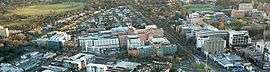 Aerial of Parkville looking north. Visible is Royal Park (top left); Royal Melbourne Hospital (centre left); Royal Parade (centre) and University of Melbourne campus (right). | |||||||||||||
 Parkville Location in metropolitan Melbourne | |||||||||||||
| Coordinates | 37°47′17″S 144°57′04″E / 37.788°S 144.951°ECoordinates: 37°47′17″S 144°57′04″E / 37.788°S 144.951°E | ||||||||||||
| Population | 6,193 (2011 census)[1] | ||||||||||||
| • Density | 1,550/km2 (4,000/sq mi) | ||||||||||||
| Established | 1861 | ||||||||||||
| Postcode(s) | 3052, 3010 | ||||||||||||
| Area | 4 km2 (1.5 sq mi) | ||||||||||||
| Location | 3 km (2 mi) from Melbourne | ||||||||||||
| LGA(s) | |||||||||||||
| State electorate(s) | |||||||||||||
| Federal Division(s) | Melbourne | ||||||||||||
| |||||||||||||
Parkville is a suburb of Melbourne, Victoria, Australia, 3 km north of Melbourne's Central Business district. Its local government areas are the Cities of Melbourne and Moreland.[2] At the 2011 Census, Parkville had a population of 6,193.
Parkville is bordered by North Melbourne to the south-west, Carlton and Carlton North to the south and east, Brunswick to the north (where a part of Parkville lies within the City of Moreland), and Flemington to the west. The suburb includes the postcodes 3052 and 3010 (University).
A major feature is the neighbouring Royal Park, Melbourne, an expansive parkland which is notable as home to the Royal Melbourne Zoological Gardens and was the athlete's village for the 2006 Commonwealth Games.
Parkville is a major education, research and healthcare precinct and home to the University of Melbourne, Monash University Pharmacy faculty, Royal Melbourne Hospital, Royal Women's Hospital, Royal Children's Hospital, the Victorian Comprehensive Cancer Centre, and CSL.
The residential areas have a high median house price due to the proximity to the city and parkland, Victorian era buildings, terrace houses and tree lined streets.
History
Toponomy
Originally known as Park ville or Park-ville, the origins of the name are uncertain. The suburb may have been named after Royal Park. Park-ville was the name of one of the early homes along Flemington Road owned by the Ryan family in the 1870s and there was once a street in Hotham named Parkville street which may have led toward this home. Before the 1870s much of the area was known as either Hotham (North Melbourne) or Carlton and during this time Parkville was simply a locality of Carlton. The name Park Ville came into common use after 1875 and was gradually shortened to its current form.
University and beginnings
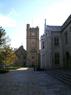
The first institution of significance erected in the Parkville area was the University of Melbourne in 1853. A housing estate commenced sales in 1861 at what is now Parkville South. In 1868 further excisions from Royal Park were made for housing estates at Parkville North along Royal Parade and Parkville West near Flemington Road. By the 1870s and 1880s, Parkville was a popular area for the middle class booming with affluent terrace housing becoming the norm.
Between the wars
During World War One and Two, Royal Park was the site of military encampments. Camp Pell in Royal Park was the temporary military camp for United States forces during the Second World War.
During the post war era, Melbourne Hospital was moved to Parkville.
In the 1960s, Parkville become the new, and current home of the Victorian College of Pharmacy, on Royal Parade, which is now a campus of Monash University.
The Athlete's Village for the 2006 Commonwealth Games was built on the grounds of the former Royal Park Psychiatric Hospital located in Parkville. The Athlete's Village has since been converted into a residential area known as Parkville Gardens.
Demographics
In Parkville 57.0% of people were born in Australia. The most common countries of birth were China (excludes SARs and Taiwan) 5.7%, Malaysia 5.1%, England 3.3%, New Zealand 2.1% and Singapore 1.7%.
66.3% of people only spoke English at home. Other languages spoken at home included Mandarin 7.8%, Cantonese 3.9%, Italian 1.6%, Malay 1.2% and French 0.7%. [1]
Housing
The residential part of Parkville South, commenced in 1861 is a Conservation Area under the Register of the National Estate and contains almost all of the suburb's housing.
Educational institutions
- University of Melbourne and associated residential colleges.
- University High School
- Monash University Parkville Campus (formerly Victorian College of Pharmacy)
- Turana Youth Training Centre (formerly Melbourne Juvenile Justice Centre), a youth corrections facility, is located in Parkville.
- Ridley Melbourne - Mission & Ministry College
Health and medical research institutions
- Royal Melbourne Hospital
- Royal Children's Hospital
- Commonwealth Serum Laboratories where vaccines and medicines are discovered and produced.
- Walter and Eliza Hall Institute of Medical Research
- Murdoch Childrens Research Institute
- Monash Institute of Pharmaceutical Science (MIPS) Part of Monash Universities Parkville Campus
- Victorian Comprehensive Cancer Centre accommodating the relocated Peter MacCallum Cancer Centre that opened in 2016.[3]
Transport

The main arterial road is Elizabeth Street, which becomes Royal Parade before becoming Sydney Road and the Hume Highway, the main highway heading towards Sydney.
Royal Park railway station is the main railway station in Parkville, located in Royal Park to the north adjacent the zoo and is on the Upfield railway line, serviced by Metro Trains Melbourne. The planned Melbourne Metro Rail Project tunnel with have an underground Parkville railway station.
Parks and open space
Royal Park

Royal Park, which Parkville was named after is the largest of Melbourne's inner city parks (181 hectares) and is home to the Royal Melbourne Zoological Gardens. The park is home to a wide range of sports and wildlife. Royal Park is home to Parkville District Cricket Club, who are based at Brens Pavilion.
Royal Park Golf Course is north of the Zoological Gardens.[4]
References
- 1 2 Australian Bureau of Statistics (31 October 2012). "Parkville (State Suburb)". 2011 Census QuickStats. Retrieved 23 June 2012.
- ↑ http://www.dse.vic.gov.au/__data/assets/pdf_file/0017/104561/Melbourne_v47.pdf
- ↑ "Our new home" (Press release). Peter MacCallum Cancer Centre. 22 June 2016. Retrieved 13 September 2016.
- ↑ Golf Select, Royal Park, retrieved 11 May 2009
External links
| Wikimedia Commons has media related to Parkville, Victoria. |