Paruro Province
| Paruro | |
|---|---|
| Province | |
 | |
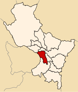 Location of Paruro in the Cusco Region | |
| Country | Peru |
| Region | Cusco |
| Capital | Paruro |
| Government | |
| • Mayor | Adolfo Santiago Fernandez Baca Loaiza (2007) |
| Area | |
| • Total | 1,984.42 km2 (766.19 sq mi) |
| Population (2005 census) | |
| • Total | 32,244 |
| • Density | 16/km2 (42/sq mi) |
| UBIGEO | 0810 |
Paruro Province is one of thirteen provinces in the Cusco Region in the southern highlands of Peru.
The provincial capital of Paruro, with population of 3,855, lies at 3,057 meters (10,032 ft) altitude.[1] Two and a half hours by bus from Cusco, in the bottom of a deep valley, it is bordered on one side by the Rio Paruro, a feeder of the Apurímac River. A number of small Inca and pre-Inca ruins are in the area, and a series of arches built by Simon Bolivar to celebrate a victory over the Spaniards.
Nearby Paqariq Tampu is one of the legendary origin sites of Manqu Qhapaq and Mama Uqllu, founders of the Inca Empire.
Boundaries
- North: Anta Province and Cusco Province
- East: Quispicanchi Province, Acomayo Province and Chumbivilcas Province
- South: Chumbivilcas Province
- West: Chumbivilcas Province and Apurímac Region
Geography
Some of the highest mountains of the province are listed below:[2]
- Achiwan
- Anqas
- Awkis
- Chaku Urqu
- Chawpi
- Ch'iyar Jaqhi
- Chuqichampi
- Inti Watana
- Kancha Q'asa
- Kimsa Chata
- Kimsa Pukyu
- Kiru
- Kunturi
- Kuntursinqa
- Khipu
- Llama Kunka
- Lluthuq Q'asa
- Mallqu Q'asa
- Mawk'a Llaqta
- Ñaqha Pukara
- Pilluni
- Puka Q'asa
- Puma Ranra
- Puma Suyru
- Puma Urqu
- Pumawasi
- Puyka
- P'unqu Q'asa
- Qiwiña
- Qullpa
- Qullu Puphasqa
- Qupani
- Quri Pata
- Q'illu
- Runtu Urqu
- Ruq'a
- Saywa
- Sullk'an Urqu
- Suyt'u
- Taway Q'asa
- Tawqa
- Tawqa Urqu
- Umaqucha
- Ura Qaqa
- Waka Pakana
- Wallata
- Waman Pata
- Wanakawri
- Wanaku
- Wark'a Simp'ana
- Warkhuyuq
- Wathiyayuq
- Wayllayuq
- Wayruru
- Waytaqucha
- Willkani
Political division
The province is divided into nine districts (Spanish: distritos, singular: distrito), each of which is headed by a mayor (alcalde). The districts, with their capitals in parenthesis, are:
- Accha (Accha)
- Ccapi (Ccapi)
- Colcha (Colcha)
- Huanoquite (Huanoquite)
- Omacha (Omacha)
- Paccaritambo (Paccaritambo)
- Paruro (Paruro)
- Pillpinto (Pillpinto)
- Yaurisque (Yaurisque)
Ethnic groups
The people in the province are mainly indigenous citizens of Quechua descent. Quechua is the language which the majority of the population (92.09%) learnt to speak in childhood, 7.56% of the residents started speaking in Spanish (2007 Peru Census).[3]
See also
References
- ↑ Paruro
- ↑ escale.minedu.gob.pe - UGEL map of the Paruro Province (Cusco Region)
- ↑ inei.gob.pe INEI, Peru, Censos Nacionales 2007
| |
|---|---|
Coordinates: 13°45′48″S 71°50′58″W / 13.76333°S 71.84944°W