La Convención Province
| La Convención | |
|---|---|
| Province | |
|
| |
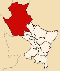 Location of La Convención in the Cusco Region | |
| Country | Peru |
| Region | Cusco |
| Capital | Quillabamba |
| Government | |
| • Mayor | Hernan De La Torre Dueñas (2007) |
| Area | |
| • Total | 30,061.82 km2 (11,606.93 sq mi) |
| Population (2005 census) | |
| • Total | 165,415 |
| • Density | 5.5/km2 (14/sq mi) |
| UBIGEO | 0809 |
La Convención Province is the largest of thirteen provinces in the Cusco Region in the southern highlands of Peru.
As part of the higher-altitude Amazon basin at the foot of the Andes, La Convención is one of three Peruvian counties that prominently figure in national coffee production, the other being Chanchamayo county in Junín state and Jaén county in Cajamarca state.
Geography
The La Convención Province is bounded to the north by the Junín Region and the Ucayali Region, to the east by the Madre de Dios Region, to the south by the Anta Province, the Calca Province and the Urubamba Province, and to the west by the Ayacucho Region and the Apurímac Region.
The Urupampa and Willkapampa mountain ranges traverse the province. Some of the highest peaks of the province are listed below:[1]
- Asulqucha
- Chawpi Urqu
- Chawpimayu
- Chuchaw Q'asa
- Chuqisapra
- Chuqitakarpu
- Hatun Wamanripa
- Inka Tampu Urqu
- Kima
- Kinwa Urqu
- Kiswar
- Kuntur Sinqa
- K'urkur Urqu
- Lanranniyuq
- Llawlliyuq
- Mantur Q'asa
- Marquni
- Ñañu Wayq'u
- Puka Puka
- Pumasillu
- Pumasillu (near Pumasilluqucha)
- Punkuyuq
- Putukuyuq
- Phaqcha
- P'anta
- Qayqu
- Qayqu (near Pumasillu)
- Qillwaqucha
- Quchapata
- Quriwayrachina
- Quysupakana
- Sara Sarayuq
- Sut'uq Mach'ay
- Suyruqucha
- Tunki Urqu
- Uqhupampa
- Uru Saywa
- Waqay Willka
- Wayllayuq
- Willka Wiqi
- Wiraquchasi
- Yana Urqu
- Yanaqucha
- Yanantin
- Yuraqmayu
Political division
The province is divided into thirteen districts (Spanish: distritos, singular: distrito), each of which is headed by a mayor (alcalde). The districts, with their capitals in parenthesis, are:
- Santa Ana (Quillabamba)
- Echarate (Echarate)
- Huayopata (Huyro)
- Kimbiri (Kimbiri)
- Maranura (Maranura)
- Ocobamba (Ocobamba)
- Pichari (Pichari)
- Quellouno (Quellouno)
- Santa Teresa (Santa Teresa)
- Vilcabamba (Lucma)
- Inkawasi (Amaybamba)
- Villa Virgen (Villa Virgen)
- Villa Kintiarina (Villa Kintiarina)
Ethnic groups
The province is inhabited by indigenous citizens: Asháninka,[2] Machiguenga,[3] Yine[4] and Quechua. Spanish is the language which the majority of the population (51.98%) learnt to speak in childhood, 39.82% of the residents started speaking using the Quechua language (2007 Peru Census).[5]
See also
| |
Sources
- ↑ escale.minedu.gob.pe - UGEL map of the La Convención Province (Cusco Region)
- ↑ www.peruecologico.com.pe/ Ashaninka
- ↑ peruecologico.com.pe Machiguenga
- ↑ peruecologico.com.pe Piro
- ↑ inei.gob.pe INEI, Peru, Censos Nacionales 2007
| |
|---|---|
Coordinates: 12°51′48″S 72°41′35″W / 12.86333°S 72.69306°W