Urubamba Province
| Urubamba | |
|---|---|
| Province | |
|
The Urubamba River in the Sacred Valley of the Urubamba Province | |
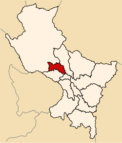 Location of Urubamba in the Cusco Region | |
| Country | Peru |
| Region | Cusco |
| Capital | Urubamba |
| Government | |
| • Mayor | Benicio Rios Ocsa (2007) |
| Area | |
| • Total | 1,439.43 km2 (555.77 sq mi) |
| Population (2007 census) | |
| • Total | 56,685 |
| • Density | 39/km2 (100/sq mi) |
| UBIGEO | 0813 |
| Website |
www |

Urubamba Province is one of thirteen provinces in the Cusco Region in the southern highlands of Peru.
Geography
The province is bounded to the north by the La Convención Province, to the east by the Calca Province, to the south by the Cusco Province and the Anta Province, and to the west by the La Convención Province.
The Urupampa and Willkapampa mountain ranges traverse the province. Some of the highest peaks of the province are listed below:[1]
- Ana Willka Q'asa
- Ch'akiqucha
- Ch'iqun
- Hatun Luychu
- K'urkur Urqu
- Llama Wasi
- Llawlliyuq
- Marquni
- Masanayuq
- Minasniyuq
- Muyuq
- Pata Kancha
- Pinkuylluna
- Puka Q'asa
- Pumawank'a
- Phutuq K'usi
- P'allqay
- Qhapaq Saya
- Qhispi Rumiyuq
- Q'illu Urqu
- Runtuqucha Q'asa
- Sallqantay
- Sallqayuq
- Sut'uq
- Tampu Mach'ay
- Taruka Kancha
- Uqhupampa
- Waqay Willka
- Waqra Tanka
- Wamanripayuq
- Wayanay
- Wayna Pikchu
- Willka Wiqi
- Yana Urqu
- Yuraq Urqu
Political division
The province is divided into seven districts (Spanish: distritos, singular: distrito), each of which is headed by a mayor (alcalde). The districts, with their capitals in parenthesis, are:
- Chinchero (Chinchero)
- Huayllabamba (Huayllabamba)
- Machupicchu (Machupicchu)
- Maras (Maras)
- Ollantaytambo (Ollantaytambo)
- Urubamba (Urubamba)
- Yucay (Yucay)
Ethnic groups
The people in the province are mainly indigenous citizens of Quechua descent. Quechua is the language which the majority of the population (51.34%) learnt to speak in childhood, 46.78% of the residents started speaking using the Spanish language (2007 Peru Census).[2]
Archaeological sites
The UNESCO World Heritage Site of Machu Pikchu is probably the most famous site among the numerous archaeological remains of the province. Other places are listed below:
See also
Images
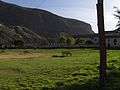 A view across one of two central parks of Yucay
Sources
- ↑ escale.minedu.gob.pe - UGEL map of the Urubamba Province (Cusco Region)
- ↑ inei.gob.pe INEI, Peru, Censos Nacionales 2007
| |
|---|---|
Coordinates: 13°18′37″S 72°07′12″W / 13.310334°S 72.12°W