Pelee, Ontario
| Pelee Island | ||
|---|---|---|
| Township (single-tier) | ||
| Township of Pelee | ||
| ||
 | ||
| Country |
| |
| Province |
| |
| Area | ||
| • Total | 41.79 km2 (16.14 sq mi) | |
| Population (2011)[1] | ||
| • Total | 171 | |
| • Density | 4.1/km2 (11/sq mi) | |

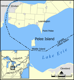
Pelee Island, Ontario, Canada /ˈpiliː/, is an island in the western half of Lake Erie. Pelee Island is connected to the Canadian and United States mainland by ferry service. At 42 km2 (16 sq mi), Pelee Island is the largest island in Lake Erie and the southernmost populated point in Canada. An Ontario Historical Plaque was erected by the province to commemorate the development of Pelee Island's role in Ontario's heritage.[2] Nearby Middle Island is the southernmost point of land in Canada.
Pelee Island is part of the Township of Pelee which has its own mayor, deputy mayor, and three councillors. It is a separated township, separate from Essex County. The township comprises nine islands, the largest being Pelee Island, and including Middle Island, Middle Sister Island, Hen Island, Big Chicken Island, Little Chicken Island, Chick Island, East Sister Island, and North Harbour Island. The total land area of all islands in the township is 41.84 km2 (16.15 sq mi).
Due to its southerly location and the moderating effect of Lake Erie, it has a slightly milder climate than inland areas.[3] Its climate is one of the mildest in Canada, and the island has long been used for vineyards and wine making. The wine industry was started here in 1860 and died out in the early twentieth century, but was restarted in the 1980s by the Pelee Island Winery.[4] The island is an agricultural based community which grows about 2,000 hectares (5,000 acres) of soybeans, about 400 hectares (1,000 acres) of wheat, 200 hectares (500 acres) of grapes, and a few hectares of specialty corn.
Pelee Island is part of an important flyway for migrating birds between Ohio, the Lake Erie islands and Point Pelee. Pelee Island has, for many years, hosted a fall pheasant hunt which attracts hunters from Canada, the United States and many other countries. The pheasant hunt brings tourist dollars to Pelee at a time of year when virtually no other activities are available thus generating important revenue in the 'off' season.
Transport
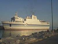
The island is serviced by two ferries, the MV Jiimaan and the MV Pelee Islander (owned by Pelee Island Transportation Company, a subsidiary of the OSTC). The MV Jiimaan is the largest passenger ferry along the Lake Erie route to Pelee Island. At 61 m (200 ft) in length, the Jiimaan can transport 400 passengers and 40 vehicles. The leisurely cruise to Pelee Island can range from one-and-a-half to just over two hours depending on departure routes. The ferry service splits the season between Leamington and Kingsville on the Ontario mainland. Leaving from Leamington from early spring until August, the ferry then finishes the season (mid December) in nearby Kingsville. The ferry from Pelee Island to Sandusky, Ohio runs only from late spring until early fall, while the Jiimaan runs from the Canadian ports of Leamington and/or Kingsville from early spring until early December. The Jiimaan was built in 1992 at Port Weller Drydocks in St. Catharines, Ontario. There will be a new ferry servicing the island beginning in 2017. When the ferries are not operating, the only practical way to get to the mainland or to Pelee Island is via airplane. In January 2004, a Cessna 208 Caravan crashed on takeoff from Pelee, killing 9 pheasant hunters and the pilot. The plane crashed into the shallow waters of Lake Erie. It is believed the plane was overloaded and potentially ice-laden according to the aviation authorities of Canada.
The older MV Pelee Islander, which continues to operate, carries 196 passengers and 14 vehicles. MV Upper Canada, which serviced Pelee prior to Jiimaan, was sent to Lake Huron (the Christian Island natives received her for transport to and from the mainland) when Jiimaan began service to Pelee. The Pelee Islander was built at Erieau, Ontario in 1960.[5]
A tender has been awarded to Asenav of Chile to build a replacement ferry[6] that can carry 399 passengers and 34 vehicles.
During the winter season (starting Dec. 11 until the start of the ferry the next year) Pelee Island Transportation Company operates an air service to the Pelee Island Airport from Windsor.[7]
Climate
Due to its southerly location and the moderating effect of Lake Erie, it has a slightly milder climate than inland areas.[3] Its climate, is one of the mildest in Canada, and the island has long been used for vineyards and wine making. It lies within the Carolinian forest region. The island has a humid continental climate (Köppen climate classification Dfa) and falls into the USDA Plant Hardiness Zone 6b.[8][9] Winters are cold with a January average of −5.0 °C (23.0 °F) and the average annual snowfall is 76 centimetres (29.9 in), which falls mainly from November to April.[10] Summers are warm and humid with a July high of 27.5 °C (81.5 °F) and a low of 18.9 °C (66.0 °F).[10] Temperatures rarely go over 32 °C (89.6 °F), averaging 4 days per year.[11] Pelee island and Point Pelee receive the fewest days with precipitation in Ontario, averaging 75 days with measurable precipitation and drought like conditions occur every 4–5 years.[12] The average annual precipitation is 891 millimetres (35 in) which is evenly distributed throughout the year with January and February being the driest months.[10] The record low was −31.5 °C (−24.7 °F) on January 20, 1985 and the record high was 41.1 °C (106.0 °F) on July 24, 1934.[10]
| Climate data for Pelee Island | |||||||||||||
|---|---|---|---|---|---|---|---|---|---|---|---|---|---|
| Month | Jan | Feb | Mar | Apr | May | Jun | Jul | Aug | Sep | Oct | Nov | Dec | Year |
| Record high °C (°F) | 17.2 (63) |
18.3 (64.9) |
23.9 (75) |
33.0 (91.4) |
37.2 (99) |
40.6 (105.1) |
41.1 (106) |
37.8 (100) |
36.7 (98.1) |
31.1 (88) |
24.4 (75.9) |
18.0 (64.4) |
41.1 (106) |
| Average high °C (°F) | −2.0 (28.4) |
−0.3 (31.5) |
5.1 (41.2) |
11.3 (52.3) |
18.0 (64.4) |
24.2 (75.6) |
27.5 (81.5) |
26.3 (79.3) |
22.7 (72.9) |
16.2 (61.2) |
8.1 (46.6) |
1.8 (35.2) |
13.2 (55.8) |
| Daily mean °C (°F) | −5 (23) |
−3.6 (25.5) |
1.7 (35.1) |
7.4 (45.3) |
13.9 (57) |
19.9 (67.8) |
23.2 (73.8) |
22.2 (72) |
18.5 (65.3) |
12.4 (54.3) |
5.4 (41.7) |
−0.9 (30.4) |
9.6 (49.3) |
| Average low °C (°F) | −8.1 (17.4) |
−7.0 (19.4) |
−1.9 (28.6) |
3.4 (38.1) |
9.7 (49.5) |
15.5 (59.9) |
18.9 (66) |
18.1 (64.6) |
14.2 (57.6) |
8.6 (47.5) |
2.5 (36.5) |
−3.7 (25.3) |
5.8 (42.4) |
| Record low °C (°F) | −31.5 (−24.7) |
−27.2 (−17) |
−21.1 (−6) |
−15.0 (5) |
−1.7 (28.9) |
1.1 (34) |
5.6 (42.1) |
5.0 (41) |
1.1 (34) |
−5.6 (21.9) |
−12.8 (9) |
−24.5 (−12.1) |
−31.1 (−24) |
| Average precipitation mm (inches) | 47.2 (1.858) |
39.5 (1.555) |
67.9 (2.673) |
82.0 (3.228) |
86.4 (3.402) |
92.2 (3.63) |
78.9 (3.106) |
87.4 (3.441) |
86.0 (3.386) |
55.5 (2.185) |
83.7 (3.295) |
84.1 (3.311) |
890.8 (35.071) |
| Average rainfall mm (inches) | 24.2 (0.953) |
23.0 (0.906) |
58.7 (2.311) |
79.9 (3.146) |
86.4 (3.402) |
92.2 (3.63) |
78.9 (3.106) |
87.4 (3.441) |
86.0 (3.386) |
55.5 (2.185) |
79.3 (3.122) |
64.5 (2.539) |
816.1 (32.13) |
| Average snowfall cm (inches) | 23.0 (9.06) |
18.3 (7.2) |
9.0 (3.54) |
2.1 (0.83) |
0 (0) |
0 (0) |
0 (0) |
0 (0) |
0 (0) |
0 (0) |
4.1 (1.61) |
19.6 (7.72) |
76.0 (29.92) |
| Average precipitation days (≥ 0.2 mm) | 6 | 6 | 7 | 8 | 7 | 8 | 7 | 7 | 7 | 6 | 8 | 8 | 84 |
| Average rainy days (≥ 0.2 mm) | 2 | 2 | 5 | 7 | 7 | 8 | 7 | 7 | 7 | 6 | 7 | 5 | 70 |
| Average snowy days (≥ 0.2 cm) | 5 | 4 | 2 | 1 | 0 | 0 | 0 | 0 | 0 | 0 | 1 | 4 | 15 |
| Source: Environment Canada.[10] | |||||||||||||
Tourism
Pelee Island is a popular tourist destination, with thousands of visitors each year. There are several key events such as the Annual Springsong Weekend that is hosted by famed Canadian author Margaret Atwood. Pelee Stone & Sky Music & Art Performances feature spoken word, live performance and visual arts weekly for the duration of the summer. The Island Unplugged Music Festival takes place at the East Park Campground and features Canadian musicians and also includes the southernmost Chili Cook Off. There is also a Farmer's Market. The season wraps with the Heritage Weekend, hosted by the Pelee Island Heritage Centre.
The Pelee Island Half Marathon attracts runners from both the United States and Canada to participate in what is billed as Canada's southernmost and most exclusive half-marathon. Only about 350 runners are allowed to register for the race which is held the first weekend in June.[13]
Cycling is promoted on the island, with bicycle rentals available. Boutiques include The Treasure Emporium, Down the Lane Boutique, Sassy Magpie and Pelee Artworks which features items by local artists, where visitors and locals can shop.
Restaurants include Conorlee's Bakery, Deli & Pizzeria; Westview Tavern; Scudder Beach Bar and Grill; and the Anchor & Wheel. The Pelee Island Wine Pavilion features dining inside an old wine barrel.
Ecotourism
Pelee Island has many interesting features that make it a one of a kind ecotourist destination. Pelee is the southernmost inhabited part of Canada and is situated on two major migratory bird routes, the Atlantic Flyway and the Mississippi flyway. The island has been designated as a globally Important Bird Area (IBA) by the Canadian partners of BirdLife International – the Canadian Nature Federation (CNF) and Bird Studies Canada (BSC). IBAs are described as “truly outstanding sites of significance nationally or internationally and sites that are exceptionally important for birds”. Every year the return of the migratory birds is celebrated on Pelee with the Annual Springsong Weekend, usually taking place on Mother's Day weekend. Pelee Island Bird Observatory located on the island work to conserve and study birds on the island, and offers visitors the opportunity to take part in tracking, tagging and photographing the wide variety of species present.
Pelee Island is one of Ontario's most botanically significant sites, and features several Nature Conservancy of Canada areas, and two Provincial Nature Reserves, Lighthouse Point Nature Reserve and Fish Point Nature Reserve. Glaciation left a variety of habitats for wildlife, such as wetlands, sand dunes, alvars (areas of limestone with a shallow overburden), and deep soils suitable to the trees of the Eastern Deciduous Forest zone. Pelee Island is home to numerous species at risk including both flora and fauna as insects, snails, mammals, birds, reptiles, and amphibians.
Species at risk
- Yellow-breasted chat
- Acadian flycatcher
- Prothonotary warbler
- Red-headed woodpecker
- Least bittern
- Chimney swift
- Bald eagle
- Blanchard’s cricket frog
- Small-mouth salamander
- Grey fox
- Eastern spiny softshell turtle
- Eastern foxsnake
- Lake Erie watersnake
- Blue racer snake
- Eastern prickly pear cactus
- Hop tree
- Kentucky coffee tree
- Red mulberry
- Wild hyacinth
History
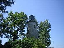
Pelee Island features an original 1833 lighthouse that was once used to guide sailors through the rocky Pelee Passage. Lake Erie is full of shipwrecks; Pelee Passage alone contains the remains of at least 15 shipwrecks. One wreck that is particularly close to the island, JJ Carroll, is just 100 feet off the East shore of Fish Point.
Pelee was the site of a battle during the Patriot War. The Battle of Pelee Island took place along what is now the Michigan-Ontario border in 1838 involving small groups of men on each side of the border seeking to "liberate" Upper Canada from the British. On February 26, 1838 300 men captured the island, and on March 3 they were repulsed and either fled the island or were captured.
Demographics
According to the 2011 census, it has a population of 171 permanent residents living in 79 households,[1] but the population can swell to over 1,500 during the summer months, with more than three thousand people on long weekends.
See also
Notes
- 1 2 "2011 Census Profile for Pelee (Township)". 2011 Cenus Data. Statistics Canada. 2012-02-11. Retrieved January 13, 2013.
- ↑ "Ontario Plaque".
- 1 2 Wake, Winifred Cairns (1997). A Nature Guide to Ontario, p. 47. University of Toronto Press. ISBN 0-8020-2755-5.
- ↑ Aspler, Tony (1999). Vintage Canada: The Complete Reference to Canadian Wines, p. 68. McGraw-Hill Ryerson. ISBN 0-07-086043-2.
- ↑ "Pelee Islander arrives".
- ↑ https://ca.news.yahoo.com/pelee-island-40-million-ferry-194547971.html
- ↑ "Pelee Island Transportation Services".
- ↑ Kottek, M.; J. Grieser; C. Beck; B. Rudolf; F. Rubel (2006). "World Map of the Köppen-Geiger climate classification updated" (PDF). Meteorol. Z. 15 (3): 259–263. doi:10.1127/0941-2948/2006/0130. Retrieved December 22, 2012.
- ↑ "Plant Hardiness Zones". Atlas of Canada. Natural Resources Canada. September 2003. Retrieved December 22, 2012.
- 1 2 3 4 5 "Pelee Island, Ontario". Canadian Climate Normals 1961–1990 (in English and French). Environment Canada. Retrieved January 26, 2013.
- ↑ "Weatherbase: Historical Weather for Pelee Island, Ontario". Weatherbase. Retrieved December 22, 2012.
- ↑ "Point Pelee National Park of Canada". Parks Canada. Retrieved December 22, 2012.
- ↑ https://raceroster.com/events/2017/9822/pelee-island-winery-half-marathon-2017
References
- Pelee township, Ontario Statistics Canada
External links

| Ohio |
|  | |||||||||
|---|---|---|---|---|---|---|---|---|---|---|---|
| Ontario | |||||||||||
| Other |
| ||||||||||
| Essex County, Ontario, Canada | |
|---|---|
| Transportation |
Current Provincial Highways: Highway 3 • Highway 77 • Highway 401 Former Provincial Highways: Highway 2 • Highway 39 • Highway 98 • Highway 107 • Highway 114 Essex County Roads: County Roads • Windsor Suburban Roads Railways: Essex Terminal Railway • Windsor Subdivision • Chatham Subdivision • CASO Subdivision |
| Municipalities | Amherstburg • Essex 1 • Kingsville • Lakeshore • LaSalle • Leamington • Pelee • Tecumseh • Windsor 2 |
| Communities | Belle River 3 • Colchester • Comber • Cottam • Deerbrook • Emeryville • Harrow 3 • Maidstone • Malden Centre • McGregor • Oldcastle • Puce • River Canard • Ruthven • St. Clair Beach3 • St. Joachim • Seacliffe • Stoney Point • Windsor • Woodslee |
| Attractions and Parks | Point Pelee National Park • Fort Malden National Historic Park • Jack Miner Bird Sanctuary • Colasanti's Tropical Gardens • ERCA • Chrysler Canada Greenway • Trans-Canada Trail |
| Geography | Bois Blanc Island • Detroit River • East Sister Island • Fighting Island • Middle Island • Peche Island • Pelee Island • Point Pelee |
| 1 County seat. 2 Separated Municipality, as of 1998. 3 Formerly a separate municipality, merged into another as of 1998. | |
| See also: List of municipalities in Ontario • Detroit, Michigan | |
Coordinates: 41°46′00″N 82°38′27″W / 41.7667°N 82.6409°W