Penn Forest Township, Carbon County, Pennsylvania
| Penn Forest Township | |
| Settlement | |
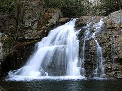 Hawk Falls in Hickory Run State Park | |
| Country | United States |
|---|---|
| State | Pennsylvania |
| County | Carbon |
| Elevation | 1,690 ft (515.1 m) |
| Coordinates | 40°52′29″N 75°40′59″W / 40.87472°N 75.68306°WCoordinates: 40°52′29″N 75°40′59″W / 40.87472°N 75.68306°W |
| Area | 74.9 sq mi (194.0 km2) |
| - land | 73.8 sq mi (191 km2) |
| - water | 1.0 sq mi (3 km2), 1.34% |
| Population | 9,581 (2010) |
| Density | 129.8/sq mi (50.1/km2) |
| Timezone | EST (UTC-5) |
| - summer (DST) | EDT (UTC-4) |
| Area code | 570 |
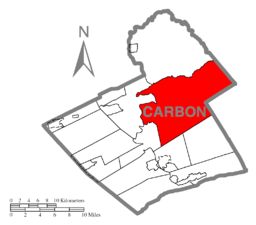 Location of Penn Forest Township in Carbon County | |
 Location of Penn Forest Township in Pennsylvania | |
 Location of Pennsylvania in the United States | |
| Website: www | |
Penn Forest Township is a township in Carbon County, Pennsylvania, United States. The population was 9,581 at the 2010 census,[1] up from 5,439 at the 2000 census.
Geography
The township is the largest by area in Carbon County, occupying a sizable portion of the eastern side of the county. According to the United States Census Bureau, the township has a total area of 74.9 square miles (193.9 km2), of which 73.8 square miles (191.2 km2) is land and 1.0 square mile (2.7 km2), or 1.40%, is water.[1] It is drained by the Lehigh River, which meanders along Penn Forest's western border through the Lehigh Gorge. Mud Run, a tributary of the Lehigh, forms the northern border of the township. Its villages include Christmans, Christmansville, and Meckesville, and its census-designated places are Albrightsville (also in Kidder Township), Indian Mountain Lake (also in Monroe County), and Towamensing Trails. A small portion of Hickory Run State Park is in the north along Mud Run.
The township's numbered roads include Pennsylvania Route 903, which crosses from northeast to southwest, and Pennsylvania Route 534, which crosses in the east and intersects PA 903 in Albrightsville. Other important roads include Hatchery Road, Maury Road, and Schock Mill Road. Interstate 476 (Pennsylvania Turnpike Northeast Extension) crosses Penn Forest north-to-south with access at an E-ZPass-only interchange with PA 903 and indirect access from the Mahoning Valley interchange to the south and the Pocono interchanges to the north.
Neighboring municipalities
- Kidder Township (north)
- Lehigh Township (west)
- Jim Thorpe (southwest)
- Franklin Township (south)
- Towamensing Township (south)
- Polk Township, Monroe County (east)
- Chestnuthill Township, Monroe County (tangent to the east)
- Tunkhannock Township, Monroe County (northeast)
Demographics
As of the census[2] of 2000, there were 5,439 people, 2,046 households, and 1,565 families residing in the township. The population density was 73.3 people per square mile (28.3/km²). There were 4,806 housing units at an average density of 64.8/sq mi (25.0/km²). The racial makeup of the township was 92.48% White, 3.36% African American, 0.22% Native American, 0.53% Asian, 0.09% Pacific Islander, 1.25% from other races, and 2.06% from two or more races. Hispanic or Latino of any race were 5.39% of the population.
There were 2,046 households, out of which 34.0% had children under the age of 18 living with them, 65.1% were married couples living together, 7.4% had a female householder with no husband present, and 23.5% were non-families. 18.0% of all households were made up of individuals, and 7.4% had someone living alone who was 65 years of age or older. The average household size was 2.65 and the average family size was 3.02.
In the township the population was spread out, with 26.0% under the age of 18, 5.2% from 18 to 24, 27.9% from 25 to 44, 26.1% from 45 to 64, and 14.8% who were 65 years of age or older. The median age was 39 years. For every 100 females there were 101.0 males. For every 100 females age 18 and over, there were 98.5 males.
The median income for a household in the township was $36,601, and the median income for a family was $40,597. Males had a median income of $39,864 versus $21,774 for females. The per capita income for the township was $17,129. About 7.0% of families and 10.6% of the population were below the poverty line, including 14.0% of those under age 18 and 10.9% of those age 65 or over.
References
- 1 2 "Geographic Identifiers: 2010 Census Summary File 1 (G001): Penn Forest township, Carbon County, Pennsylvania". U.S. Census Bureau, American Factfinder. Retrieved April 7, 2015.
- ↑ "American FactFinder". United States Census Bureau. Retrieved 2008-01-31.
External links
Municipalities and communities of Carbon County, Pennsylvania, United States | ||
|---|---|---|
| Boroughs | 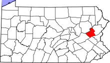 | |
| Townships | ||
| CDPs | ||
| Unincorporated communities | ||
| Footnotes | ‡This populated place also has portions in an adjacent county or counties | |