Pennant Hills, New South Wales
| Pennant Hills Sydney, New South Wales | |||||||||||||
|---|---|---|---|---|---|---|---|---|---|---|---|---|---|
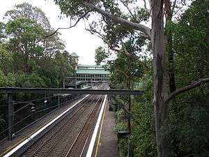 Looking above towards the Pennant Hills railway station. | |||||||||||||
| Population | 7,031 (2011 census)[1] | ||||||||||||
| Postcode(s) | 2120 | ||||||||||||
| Elevation | 167 m (548 ft) | ||||||||||||
| Location | 25 km (16 mi) north of Sydney CBD | ||||||||||||
| LGA(s) | Hornsby | ||||||||||||
| Region | Northern Suburbs | ||||||||||||
| State electorate(s) | Epping, Hornsby | ||||||||||||
| Federal Division(s) | Berowra | ||||||||||||
| |||||||||||||
Pennant Hills is a suburb in the Northern Suburbs of Sydney, New South Wales, Australia. Pennant Hills is located 25 kilometres north of the Sydney central business district in the local government area of Hornsby Shire.
History
The area was first explored by Governor Arthur Phillip shortly after 15 April 1788. It was noted that the party saw 'fine views of the mountains inland' (the Blue Mountains). Governor Phillip 'did not doubt that a large river would be found' nearby.
The first white settlement occurred in the area with the establishment of convict timber camps in the time of Governor Lachlan Macquarie. Permanent white settlement of Pennant Hills began only in the 1840s and took off with the arrival of the Northern railway line in the 1880s. In August 1912 the federal government opened a Wireless Telegraphy Station, the first of its kind on a national level.[2] The suburb has grown considerably since the 1950s, when the motor car became commonplace.
There are two theories about the origin of the suburb's name. One is that the name comes from a hill where a pennant was flown as a signal during the early days of New South Wales. However, though such signals were certainly used, there is no evidence that such a pennant was ever flown at what is now Pennant Hills, but in the early 19th century the name applied to the whole ridge down as far as Mobbs Hill, which has a Telegraph Road to commemorate the signalling station. Also, references to the suburb of Pennant Hills were written 20 years before the establishment of pennant stations (Patrick 1994:79-80). Elizabeth MacArthur records receiving a flag signal at Parramatta that her husband John had returned from England in 1806. The other theory says that Pennant Hills was named after an 18th Century botanist, Thomas Pennant (Patrick 1994:79-80), though there is no contemporary evidence for this either. The fact that the area was first referred to as "Pendant Hills" in the Sydney Gazette when first published in 1803 makes this theory unlikely, as there was no Thomas Pendant either.
The name Pennant Hills originally applied to the area now known as West Pennant Hills. However, when the northern railway line was built it passed through what is now Pennant Hills, so a suburb grew around the station and took on the name. The area around Thompsons Corner was renamed West Pennant Hills. Pennant Hills is hilly and the highest altitude is at Observatory Park on Pennant Hills Road, which once was the site of the old astronomical observatory.
During the 1960s and 1970s, Pennant Hills was the site of Chelmsford Private Hospital, where the unorthodox psychiatric Deep Sleep Therapy conducted by Dr Harry Bailey resulted in the deaths of dozens of patients.
Commercial areas
Pennant Hills is one of the major commercial centres of Hornsby Shire, along with Epping, Carlingford and Hornsby. Several dozen shops are located at the north-west of the railway line, along with the local Pennant Hills Library. Residential houses are found in all areas in Pennant Hills, with recent modern apartments and office towers found along Pennant Hills Road. A significant commercial/industrial area can be found along Pennant Hills Road.
Pennant Hills is home to several entertainment venues including the Pennant Hills Hotel incorporating Patricks Nightclub.
Transport
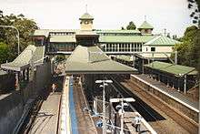
Pennant Hills railway station is on the North Shore, Northern & Western Line of the Sydney Trains network.
Pennant Hills Road is one of Sydney's major thoroughfares. Bus services by Transdev NSW and Hillsbus have their terminus in Pennant Hills and run to West Pennant Hills, Castle Hill and Cherrybrook.
Churches
Pennant Hills was established as a Catholic parish in 1928 and a number of Catholic churches have been built since then. The parish's current church, St. Agathas, was built in 1979. St Mark's Anglican Church,[3] Pennant Hills Baptist Church[4] and a Pennant Hills Uniting Church[5] also serve Pennant Hills.
Pennant Hills is also home to the first Danish Church in Australia. Crown Prince Frederik and Crown Princess Mary of Denmark made an official visit there on 6 March 2005.[6]
Schools
Pennant Hills has two public schools Pennant Hills Public School established in 1925[7] and Pennant Hills High School established in 1966,[8] and two Catholic schools, Mount St Benedict College a girls secondary school [9] and St. Agatha's Catholic Primary School.[10]
Sport and recreation
- Pennant Hills Park - home to a Rugby/Cricket field, an Aussie Rules/Cricket field, a Soccer field, a large number of tennis courts, one of the main netball facilities in the area (including a new indoor court), two hockey fields and an archery range. It is surrounded by beautiful bushland, with numerous walking tracks. The Baden-Powell Scout Centre also backs onto bushland in the area. There are a number of walks and runs in or originating from the park.
Population
Demographics
The population according to the 2011 census was 7,031. Of these:[1]
- The median age was 40 years, compared to the national median of 37 years. Children aged 0–14 years made up 18.1% of the population and people aged 65 years and over made up 15.6% of the population.
- 63.0% of people were born in Australia; the next most common countries of birth were China (excludes SARs and Taiwan) 4.1%, England 3.7%, India 3.6%, Hong Kong (SAR of China) 2.9% and Korea, Republic of (South) 2.6%.
- 27.9% of employed people travelled to work on public transport and 52.1% by car (either as driver or as passenger).
Notable residents
- Former Attorney General of Australia Philip Ruddock
- St Kilda midfielder Lenny Hayes, who played for the Pennant Hills Demons in the NSW Football League.
- Essendon tagger Mark McVeigh, who also played for the Demons in the NSW Football League.
- Sydney Swans Football Club midfielder Jarrad McVeigh, who also played for Pennant Hills Demons in the NSW Football League.
- John and Ilsa Konrads, siblings and world record-breaking swimmers.
- Michaela Baranov, a contestant on the seventh season of The X Factor Australia
- Geraint F. Lewis, astrophysicist at the University of Sydney
Climate
Because of its elevation, Pennant Hills has a mean of 21.8 °C (71.2 °F) in the warmest month, which is just below the subtropical isotherm of 22 °C (72 °F). As such, the Pennant Hills area, like most of the Hills District suburbs, have an Oceanic climate (Cfb). Its highs are around two degrees warmer than Sydney CBD in the summer, and a degree cooler in the winter. Whilst the rainfall is evenly distributed, the wettest month is March and the driest is September.
| Climate data for Pennant Hills | |||||||||||||
|---|---|---|---|---|---|---|---|---|---|---|---|---|---|
| Month | Jan | Feb | Mar | Apr | May | Jun | Jul | Aug | Sep | Oct | Nov | Dec | Year |
| Average high °C (°F) | 27.6 (81.7) |
27.3 (81.1) |
25.5 (77.9) |
22.2 (72) |
19.1 (66.4) |
16.3 (61.3) |
15.8 (60.4) |
17.9 (64.2) |
20.9 (69.6) |
23.4 (74.1) |
25.1 (77.2) |
27.0 (80.6) |
22.3 (72.1) |
| Daily mean °C (°F) | 21.8 (71.2) |
21.7 (71.1) |
20.1 (68.2) |
17.0 (62.6) |
13.8 (56.8) |
11.3 (52.3) |
10.5 (50.9) |
10.9 (51.6) |
14.5 (58.1) |
17.1 (62.8) |
19.1 (66.4) |
21.0 (69.8) |
16.57 (61.82) |
| Average low °C (°F) | 16.1 (61) |
16.1 (61) |
14.8 (58.6) |
11.8 (53.2) |
8.6 (47.5) |
6.3 (43.3) |
5.2 (41.4) |
6.1 (43) |
8.1 (46.6) |
10.8 (51.4) |
13.1 (55.6) |
15.0 (59) |
11.0 (51.8) |
| Average precipitation mm (inches) | 100.6 (3.961) |
115.8 (4.559) |
121.7 (4.791) |
104.5 (4.114) |
81.9 (3.224) |
111.4 (4.386) |
80.6 (3.173) |
63.5 (2.5) |
56.3 (2.217) |
69.0 (2.717) |
78.0 (3.071) |
92.1 (3.626) |
1,074.7 (42.311) |
| Average precipitation days (≥ 0.2 mm) | 10.6 | 11.4 | 12.1 | 11.3 | 9.5 | 10.9 | 9.2 | 8.5 | 8.8 | 9.5 | 9.9 | 10.6 | 122.3 |
| Source: Bureau of Meteorology (temperatures, 1907-1943)[11] | |||||||||||||
References
- 1 2 Australian Bureau of Statistics (31 October 2012). "Pennant Hills (State Suburb)". 2011 Census QuickStats. Retrieved 7 November 2012.
- ↑ Crowley, Frank (1974), A New History of Australia, William Heinemann, Melbourne, Victoria, p. 301
- ↑ "St Mark's Anglican Church Pennant Hills". Retrieved 23 March 2013.
- ↑ "Pennant Hills Baptist Church". Retrieved 23 March 2013.
- ↑ "Pennant Hills Uniting Church". Retrieved 23 March 2013.
- ↑ "The Danish Church in Australia". Church in Sydney has been the setting for several major events, from the Olympics in 2000, the inauguration of the church in Pennant Hills in 2002 and the visit of the royal couple in 2005, to 'Frederik's Church' was named by the Crown Prince in 2009. Retrieved 23 March 2013.
- ↑ "Pennant Hills Public School". Pennant Hills Public School, established in 1925 and situated on two sites 500 metres apart. Retrieved 23 March 2013.
- ↑ "Pennant Hills High School". Pennant Hills High School is set in large grounds and situated in a well-established residential area in the north-west of Sydney. The school was established in 1966, and prides itself on being an excellent comprehensive co-educational high school. Retrieved 23 March 2013.
- ↑ "Mount St Benedict College". Retrieved 23 March 2013.
- ↑ "St Agatha's Catholic Primary School". Retrieved 23 March 2013.
- ↑ "Climate statistics for Pennant Hills". Bureau of Meteorology. Retrieved 19 November 2013.
Sources
- Patrick, T.G. (1994). Street Names of Pennant Hills. Australia: Silicon Quill. ISBN 0-646-21003-3.
External links
- Joan Rowland (2008). "Pennant Hills". Dictionary of Sydney. Retrieved 28 September 2015. [CC-By-SA]
Coordinates: 33°44′32″S 151°03′59″E / 33.74236°S 151.06643°E