Pennsylvania Route 181
| ||||
|---|---|---|---|---|
 | ||||
| Route information | ||||
| Maintained by PennDOT | ||||
| Length: | 9.089 mi[1] (14.627 km) | |||
| Major junctions | ||||
| South end: |
| |||
|
| ||||
| North end: |
| |||
| Location | ||||
| Counties: | York | |||
| Highway system | ||||
| ||||

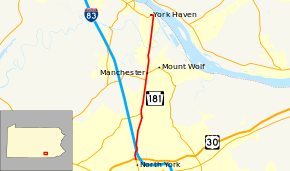
Pennsylvania Route 181 (PA 181) is a 9-mile-long (14 km) north–south state route in York County in south central Pennsylvania. Its southern terminus is at Interstate 83 Business (I-83 Bus.) and U.S. Route 30 (US 30) in North York. Its northern terminus is at the southern terminus of PA 382 in York Haven. PA 181 heads north from US 30 as a four-lane divided highway concurrent with I-83 Bus to an interchange with I-83, where I-83 Bus. reaches its northern terminus. From here, PA 181 continues north as a two-lane undivided road through suburban areas, intersecting PA 238 in Emigsville and PA 921 in Manchester. The route runs through rural land before it comes to York Haven.
The road between York and York Haven was designated as part of PA 24 in 1928. In the 1950s, US 111 Alternate (US 111 Alt.) became concurrent with PA 24 between York and I-83/US 111 in North York. PA 181 was designated between PA 250 (now US 30) in North York and PA 382 in York Haven in the 1960s after the north end of PA 24 was truncated to east of York; I-83 Bus. also replaced US 111 Alt. The section of the route between US 30 and I-83 became a divided highway in 2003.
Route description
PA 181 begins at an intersection with US 30 in Manchester Township, heading north concurrent with I-83 Bus. on North George Street, a four-lane divided highway. South of US 30, I-83 Bus. continues south toward North York. The road passes businesses before heading into residential areas. The highway passes more commercial establishments as it comes to an interchange with I-83. At this point, I-83 Bus. ends and PA 181 continues north, narrowing into a two-lane undivided road as it passes a mix of residences and businesses. The route passes through the community of Emigsville and comes to an intersection with PA 238, at which point the route runs a short distance to the west of Norfolk Southern's York Secondary railroad line. Past this junction, the road enters more wooded surroundings and continues into East Manchester Township, where it becomes North George Street Extended. Here, PA 181 runs farther to the west of the railroad tracks and passes industrial and commercial establishments. The route enters Manchester and becomes Main Street as it is lined with homes.[2][3]
PA 181 forms a concurrency with PA 921 as the road passes residences and businesses in the center of town before PA 921 turns east onto Maple Street. After this, the route enters residential areas, crossing back into East Manchester Township and becoming North George Street Extended again. The road enters wooded areas of homes before it crosses the Conewago Creek into Newberry Township, where the road name becomes York Haven Road. The road passes more housing developments before entering a mix of farms and woods. PA 181 continues into York Haven and becomes Front Street as it passes more homes and comes to its northern terminus at an intersection with the southern terminus of PA 382.[2][3]
History
When Pennsylvania legislated routes in 1911, what is now PA 181 was the southern portion of Legislative Route 250, which ran between York and the Harrisburg area.[4] In 1928, the road between York and York Haven became a part of PA 24, a route which ran between the Maryland border and New Cumberland. The section of the route between York and York Haven was a paved road.[5] In the 1950s, US 111 Alt. was designated concurrent with PA 24 between York and the interchange with I-83/US 111 in North York.[6] In the 1960s, the northern terminus of PA 24 was cut back to east of York, and PA 181 replaced the PA 24 designation between PA 250 (now US 30) in North York and PA 382 in York Haven. In addition, I-83 Bus. replaced the US 111 Alt. designation concurrent with PA 181 south of the I-83 interchange.[7] In 2003, PA 181 was widened into a divided highway between US 30 and I-83.[8]
Major intersections
The entire route is in York County.
| Location | mi[1] | km | Destinations | Notes | |
|---|---|---|---|---|---|
| Manchester Township | 0.000 | 0.000 | South end of I-83 Business concurrency | ||
| 0.566 | 0.911 | Exit 22 (I-83), north end of I-83 Business concurrency | |||
| 2.852 | 4.590 | Eastern terminus of PA 238 | |||
| Manchester | 4.947 | 7.961 | South end of PA 921 concurrency | ||
| 5.368 | 8.639 | North end of PA 921 concurrency | |||
| York Haven | 9.089 | 14.627 | Southern terminus of PA 382 | ||
1.000 mi = 1.609 km; 1.000 km = 0.621 mi
| |||||
See also
 U.S. Roads portal
 Pennsylvania portal
References
- 1 2 Bureau of Maintenance and Operations (January 2015). Roadway Management System Straight Line Diagrams (Report) (2015 ed.). Pennsylvania Department of Transportation. Retrieved June 30, 2015.
- York County (PDF)
- 1 2 Google (April 12, 2013). "Pennsylvania Route 181" (Map). Google Maps. Google. Retrieved April 12, 2013.
- 1 2 York County, Pennsylvania Highway Map (PDF) (Map). PennDOT. 2011. Retrieved February 22, 2011.
- ↑ Map of Pennsylvania Showing State Highways (PDF) (Map). Pennsylvania Department of Highways. 1911. Retrieved January 1, 2014.
- ↑ Map of Pennsylvania (Map). Pennsylvania Department of Highways. 1928. Retrieved May 7, 2015.
- ↑ Official Map of Pennsylvania (back) (PDF) (Map). Pennsylvania Department of Highways. 1960. Retrieved January 16, 2014.
- ↑ Official Map of Pennsylvania (PDF) (Map). Pennsylvania Department of Highways. 1970. Retrieved December 17, 2014.
- ↑ York County, Pennsylvania Highway Map (PDF) (Map). PennDOT. 2003. Retrieved November 30, 2015.
External links
- Kitsko, Jeffrey J. (2011). "PA 181". Pennsylvania Highways. pp. 151–200. Retrieved December 5, 2011.
- Prince, Adam J. (2002). "PA 181". State-Ends.com. Retrieved December 5, 2011.