Pennsylvania Route 426
| |||||||
|---|---|---|---|---|---|---|---|
 | |||||||
| Route information | |||||||
| Maintained by PennDOT | |||||||
| Length: | 26.92 mi[1] (43.32 km) | ||||||
| Southern section | |||||||
| Length: | 19.85 mi[1] (31.95 km) | ||||||
| South end: |
| ||||||
| Major junctions: |
| ||||||
| North end: |
| ||||||
| Northern section | |||||||
| Length: | 7.07 mi[1] (11.38 km) | ||||||
| South end: |
| ||||||
| North end: |
| ||||||
| Location | |||||||
| Counties: | Warren, Erie | ||||||
| Highway system | |||||||
| |||||||

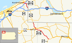
Pennsylvania Route 426 (PA 426) is a 26-mile-long (42 km) state highway in Warren and Erie counties of Pennsylvania. The route is split up into two segments, connected by New York State Route 426 through New York.
The southernmost terminus is at PA 27 in Pittsfield Township and the northernmost terminus is at PA 89 in North East.
Route description
PA 426 begins at an intersection with PA 27 west of Pittsfield in Pittsfield Township. The route heads northwest through rural Warren County, intersecting Old PA 77 (also formerly known as PA 277) at Spring Creek on its way to the Erie County line and the city of Corry beyond. PA 426, now East Main Street, proceeds west through southern Corry to an intersection with PA 77 (West Main Street) at Center Street. PA 426 turns north onto Center, crossing over a set of railroad tracks immediately north of the junction with PA 77 and passing through northern Corry prior to meeting U.S. Route 6 near the northern city line. Outside of Corry, PA 426 becomes Hare Creek Road, named for the waterway that PA 426 parallels into New York, where it becomes NY 426.
At the opposite end of NY 426, the route re-enters Pennsylvania as the northern segment of PA 426. Like most of the areas surrounding the southern segment of PA 426, most of the northern portion is as equally rural. Other than the two routes at its termini, the northern PA 426 does not intersect any signed routes along its length. The route heads northwest, then west from the state line as Findley Lake Road. In the area surrounding North East, PA 426 passes under Interstate 90 prior to terminating at PA 89 near the southern edge of the borough.
History
PA 426 was established in 1928, in Bedford County, northwest of Breezewood, as a short spur of Pennsylvania Route 26. By 1940, the designation was removed. The route existed on what is today the southernmost segment of Pennsylvania Route 36.
In the 1930s and 1940s, what is now PA 426, had many designations. The northern segment of route had no number in the 1930s. From Garland to Spring Creek, the route was Pennsylvania Route 77. From Spring Creek to Corry, it was designated as Pennsylvania Route 177. From the city of Corry to the New York state line, Pennsylvania Route 189 ran on PA 426.[2][3]
By 1950, the route was commissioned along where it mostly runs today. The only exception was the southernmost segment of PA 426, which was still designated as PA 77 from Spring Creek to Garland.[4]
By 1980, the southernmost section was redesignated from PA 77.[5]
Major intersections
Southern segment
| County | Location | mi[1] | km | Destinations | Notes |
|---|---|---|---|---|---|
| Warren | Pittsfield Township | 0.00 | 0.00 | ||
| Erie | Corry | 13.61 | 21.90 | Eastern terminus of PA 77 | |
| 14.74 | 23.72 | ||||
| Wayne Township | 19.85 | 31.95 | Southern terminus of NY 426 | ||
| 1.000 mi = 1.609 km; 1.000 km = 0.621 mi | |||||
Northern segment
The entire route is in Erie County.
| Location | mi | km | Destinations | Notes | |
|---|---|---|---|---|---|
| North East Township | 0.00 | 0.00 | Continuation into New York | ||
| North East | 7.07 | 11.38 | |||
| 1.000 mi = 1.609 km; 1.000 km = 0.621 mi | |||||
See also
 U.S. Roads portal
 Pennsylvania portal
References
- 1 2 3 4 DeLorme Street Atlas USA 2007 software, Toogle Measure Tool
- ↑ Pennsylvania state map (PDF) (Map). Pennsylvania Department of Highways. 1930. Retrieved 2007-09-12.
- ↑ Pennsylvania state map (PDF) (Map). Pennsylvania Department of Highways. 1940. Retrieved 2007-09-12.
- ↑ Pennsylvania state map (PDF) (Map). Pennsylvania Department of Highways. 1950. Retrieved 2007-09-12.
- ↑ Pennsylvania state map (PDF) (Map). Pennsylvania Department of Highways. 1980. Retrieved 2007-09-12.