Pennsylvania Route 52
| ||||
|---|---|---|---|---|
 | ||||
| Route information | ||||
| Maintained by PennDOT | ||||
| Length: | 11.782 mi[1] (18.961 km) | |||
| Existed: | 1928 – present | |||
| Tourist routes: | Brandywine Valley Scenic Byway | |||
| Major junctions | ||||
| South end: |
| |||
|
| ||||
| North end: |
| |||
| Location | ||||
| Counties: | Chester | |||
| Highway system | ||||
| ||||

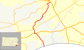
Pennsylvania Route 52 (PA 52) is a 11.8-mile-long (19.0 km) state highway located in southeast Pennsylvania. The southern terminus of the route is at the Pennsylvania-Delaware state line near Kennett Square, where PA 52 continues as Delaware Route 52 (DE 52). The northern terminus is at U.S. Route 322 Business (US 322 Bus.) in West Chester. Near the Kennett Township community of Longwood, it has about a 1-mile (1.6 km) wrong-way concurrency with US 1. PA 52 passes through suburban and rural areas along its route.
PA 52 was first designated by 1928, continuing northeast from West Chester to New Hope along a concurrency with US 122 (later US 202). This concurrency was removed by 1930 and the northern terminus of PA 52 was cut back to its current location in West Chester. In 2011, a portion of PA 52 north of US 1 was realigned.
Route description
PA 52 begins at the Delaware border in Pennsbury Township, Chester County, at which point the road continues south into Delaware as DE 52. From the state line, the road heads north-northwest on two-lane undivided Kennett Pike through wooded residential areas. The road crosses into Kennett Township and heads northwest to the community of Mendenhall, where it crosses an East Penn Railroad line. Farther northwest, PA 52 comes to an intersection with US 1 (Baltimore Pike) and turns west to form a concurrency with that route, which is a four-lane divided highway that passes fields. Near Longwood Gardens, PA 52 splits from US 1 by heading north on Lenape Road. The road runs a short distance east of the border between East Marlborough Township to the west and Pennsbury Township to the east as it passes through a mix of woods and fields, intersecting PA 926.[2][3]
Past this intersection, the road passes through forested residential areas, crossing into Pocopson Township as it winds more to the northeast. In the community of Lenape, PA 52 crosses another East Penn Railroad line prior to crossing the Brandywine Creek into Birmingham Township. Here, the road turns northwest onto Creek Road (the old alignment of PA 100) prior to continuing northeast along Lenape Road into East Bradford Township. The route passes through areas of woods, fields, and housing developments prior to intersecting West Rosedale Avenue. At this point, PA 52 heads northwest on Bradford Avenue, forming the border between East Bradford Township to the west and West Chester to the east, passing homes. The route makes a turn northeast onto Price Street, fully entering West Chester, where it continues through residential areas. The route comes to its northern terminus at US 322 Bus. (South High Street) a short distance north of the West Chester University campus. At this intersection, the old alignment of PA 100 turned left onto High Street.[2][3]
The section of PA 52 south of West Chester is part of the Brandywine Valley Scenic Byway, a Pennsylvania Scenic Byway.[4]
History
When Pennsylvania first legislated routes in 1911, what would become PA 52 was legislated as Legislative Route 134 between the Delaware border and West Chester, Legislative Route 143 between West Chester and Norristown, Legislative Route 178 between Norristown and Buckingham, and Legislative Route 155 between Buckingham and New Hope.[5] PA 52 was first designated by 1928 to run from the Delaware border northeast to the New Jersey border at the Delaware River in New Hope, following its current routing to West Chester, where it reached an intersection with US 122 at High Street. PA 52 ran concurrent with US 122 between West Chester and New Hope by way of Paoli, King of Prussia, Norristown, Montgomeryville, Chalfont, Doylestown, and Buckingham.[6] By 1930, the concurrency with US 122 (later US 202) was removed, leaving the northern terminus at US 122 (High Street, now US 322 Bus.).[7] When first assigned, PA 52 ran concurrent with PA 62 between Lenape and West Chester.[6] By 1940, PA 62 was renumbered to PA 100.[8] In 2003, the PA 100 concurrency was removed when the southern terminus of that route was cut back from the Delaware border to north of West Chester.[9]
In 2010, construction began to relocate PA 52 onto a new alignment between US 1 and PA 926 in order to improve traffic flow.[10] This shortened but did not eliminate the wrong-way concurrency between US 1 and PA 52. The new alignment of PA 52 opened on October 25, 2011 at a cost of $15.4 million.[11] With completion of the new alignment, the former PA 52 south of Webb Barn Lane became an access road to Longwood Gardens while the rest of the road was slated to be torn up.[12]
Major intersections
The entire route is in Chester County.
| Location | mi[1] | km | Destinations | Notes | |
|---|---|---|---|---|---|
| Pennsbury Township | 0.000 | 0.000 | Delaware state line | ||
| Kennett Township | 2.987 | 4.807 | Southern terminus of US 1 concurrency | ||
| 3.675 | 5.914 | Northern terminus of US 1 concurrency | |||
| Pennsbury Township | 4.618 | 7.432 | |||
| West Chester | 11.782 | 18.961 | |||
1.000 mi = 1.609 km; 1.000 km = 0.621 mi
| |||||
See also
 U.S. Roads portal
 Pennsylvania portal
References
- 1 2 Bureau of Maintenance and Operations (January 2015). Roadway Management System Straight Line Diagrams (Report) (2015 ed.). Pennsylvania Department of Transportation. Retrieved June 30, 2015.
- Chester County (PDF)
- 1 2 Google (2010-11-27). "overview of Pennsylvania Route 52" (Map). Google Maps. Google. Retrieved 2010-11-27.
- 1 2 Chester County, Pennsylvania Highway Map (PDF) (Map). PennDOT. 2010. Retrieved 2010-11-27.
- ↑ "Brandywine Valley". VisitPA.com. Retrieved March 27, 2012.
- ↑ Map of Pennsylvania Showing State Highways (PDF) (Map). Pennsylvania Department of Highways. 1911. Retrieved January 1, 2014.
- 1 2 Pennsylvania Highway Map (Philadelphia Metro) (Map). Gulf Oil. 1928. Retrieved November 8, 2007.
- ↑ Tourist Map of Pennsylvania (PDF) (Map). Pennsylvania Department of Highways. 1930. Retrieved January 1, 2014.
- ↑ Official Road Map of Pennsylvania (PDF) (Map). Pennsylvania Department of Highways. 1940. Retrieved January 1, 2014.
- ↑ Petersen, Nancy (October 9, 2003). "Route 100 loses its way through West Chester". The Philadelphia Inquirer. Retrieved January 20, 2014.
- ↑ Schwartzman, Rich (September 15, 2010). "Relocation of Route 52 is underway". Chadds Ford Live. Retrieved September 16, 2013.
- ↑ "PennDOT to Open New Route 52 Alignment in Chester County". PennDOT. October 25, 2011. Retrieved September 16, 2013.
- ↑ Maye, Fran (August 6, 2010). "Work set to begin on Route 52 relocation". Daily Local News. Retrieved August 11, 2010.