Delaware Route 52
| ||||
|---|---|---|---|---|
 | ||||
| Route information | ||||
| Maintained by DelDOT | ||||
| Length: | 7.87 mi[1] (12.67 km) | |||
| Existed: | 1936[2] – present | |||
| Tourist routes: |
| |||
| Major junctions | ||||
| South end: |
| |||
|
| ||||
| North end: |
| |||
| Location | ||||
| Counties: | New Castle | |||
| Highway system | ||||
| ||||

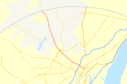
Delaware Route 52 (DE 52) is a state highway in New Castle County, Delaware. The route runs from U.S. Route 13 Business (US 13 Bus.) in downtown Wilmington north to Pennsylvania Route 52 (PA 52) at the Pennsylvania border near Centerville. DE 52 runs through the city of Wilmington and passes through areas of the Brandywine Valley north of Wilmington. DE 52 intersects Interstate 95 (I-95)/US 202 and DE 2 in Wilmington and DE 100/DE 141 and DE 82 in Greenville. The entire route is designated as part of the Brandywine Valley National Scenic Byway, a National Scenic Byway and Delaware Byway while most of the route is also designated as part of the Harriet Tubman Underground Railroad Byway of the Delaware Byways system. The road was built as the Kennett Pike, a turnpike, between 1811 and 1813 at a cost of $30,000. The Kennett Pike was bought by Pierre S. du Pont, II in 1919 and upgraded to a state highway; which he paved at a cost of $85,000 per mile. Pierre S. du Pont, II later sold it to the State of Delaware for $1. The road received the DE 52 designation by 1936.
Route description
DE 52 begins at US 13 Bus., which is routed on the one-way pair of North Walnut Street northbound and North King Street southbound, in downtown Wilmington. From here, DE 52 follows the one-way pair of East 11th Street eastbound and East 12th Street westbound to the northwest, forming the northern boundary of Rodney Square along East 11th Street. The route becomes West 11th Street eastbound and West 12th Street westbound at the North Market Street intersection. The one-way pair carries three lanes in each direction and heads northwest past downtown high-rise buildings, passing to the north of the DuPont Building along West 11th Street between North Market and North Orange streets and passing to the south of 1201 North Market Street along West 12th Street just west of North Market Street. Both directions of DE 52 merge onto Delaware Avenue, an eight-lane divided highway, and the route reaches an interchange with I-95/US 202. Past this interchange, the route narrows to six lanes and leaves downtown Wilmington. DE 52 splits from Delaware Avenue by continuing northwest on Pennsylvania Avenue, a four-lane undivided road that heads to the north of the Ursuline Academy and passes through urban areas of homes and businesses. The road intersects the eastern terminus of DE 2 in a commercial area and passes under CSX's Philadelphia Subdivision. The route runs through more residential areas north of the Wawaset Park neighborhood, passing to the northeast of the Wilmington Campus of the University of Delaware.[3][4]
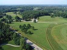
DE 52 leaves Wilmington and becomes Kennett Pike, heading through wooded areas of suburban homes. The road heads into Greenville and widens into a divided highway as it comes to an interchange with the DE 100/DE 141 freeway. Past this interchange, the route continues into business areas, crossing an East Penn Railroad line before passing to the east of Alexis I. duPont High School. DE 52 leaves Greenville and narrows to a two-lane undivided road as it heads into wooded areas then open fields to the west and Twin Lakes Farm and Twin Lakes Brewing Company, intersecting the southern terminus of DE 82. The road continues through more forested suburban areas, passing to the west of the Wilmington Country Club and to the east of the Delaware Museum of Natural History. The route passes to the west of the Winterthur Museum and Country Estate and heads into the community of Centerville. DE 52 continues northwest to its northern terminus at the Pennsylvania border, where it continues into that state as PA 52 to Longwood Gardens and West Chester.[3][4]
The entire length of DE 52 is part of the Brandywine Valley National Scenic Byway, a National Scenic Byway and Delaware Byway.[5][6] The route between Washington and West streets in Wilmington and the Pennsylvania border is also part of the Harriet Tubman Underground Railroad Byway of the Delaware Byways system.[7] DE 52 has an annual average daily traffic count ranging from a high of 37,694 vehicles at the Dupont Road intersection to a low of 5,654 vehicles at the southern terminus at US 13 Bus.[1] All of DE 52 is part of the National Highway System.[8]
History
On January 21, 1811, the Wilmington and Kennett Turnpike Company was incorporated to build a turnpike from Wilmington to the Pennsylvania border at Centreville.[9] The road was built between 1811 and 1813 at a cost of $30,000.[9][10] The charter of the turnpike gave Christiana Hundred the option to purchase the road in 1820 and remove the tolls.[9] The Kennett Pike had two toll gates north of Wilmington.[10] In 1919, Pierre S. du Pont bought the road and the toll gates were removed. The road was widened and paved following the sale and eventually sold to the Delaware State Highway Department.[10][11] When Delaware designated state highways by 1936, DE 52 was designated onto its current alignment.[2] In 1939, the route was widened to four lanes between Rising Sun Lane and Barley Mill Road to alleviate traffic congestion during peak hours.[12] The portion of DE 52 along Delaware Avenue was widened to four lanes in November 1940.[13] In 2002, DE 52 was designated as part of the Brandywine Valley Scenic Highway in the Delaware Scenic and Historic Highways system; it was designated a National Scenic Byway in 2005.[14]
Major intersections
Mileposts run from north to south. The entire route is in New Castle County.
| Location | mi[1] | km | Destinations | Notes | |
|---|---|---|---|---|---|
| Wilmington | 7.87 | 12.67 | Southern terminus | ||
| 7.76 | 12.49 | ||||
| 7.15 | 11.51 | I-95/US 202 exit 7 | |||
| Eastern terminus of DE 2 | |||||
| 6.38 | 10.27 | ||||
| Greenville | 4.62 | 7.44 | Interchange | ||
| 3.32 | 5.34 | Southern terminus of DE 82 | |||
| Centerville | 0.00 | 0.00 | Pennsylvania state line, northern terminus | ||
| 1.000 mi = 1.609 km; 1.000 km = 0.621 mi | |||||
See also
 U.S. Roads portal
 Delaware portal
References
- 1 2 3 Staff (2011). "Traffic Count and Mileage Report: Interstate, Delaware, and US Routes" (PDF). Delaware Department of Transportation. Retrieved May 17, 2012.
- 1 2 Delaware State Highway Department; The National Survey Co. (1936). Official Road Map of the State of Delaware (PDF) (Map) (1936–37 ed.). Dover: Delaware State Highway Department. Retrieved November 24, 2015.
- 1 2 Delaware Department of Transportation (2008). Delaware Official Transportation Map (PDF) (Map). Dover: Delaware Department of Transportation. Retrieved November 24, 2015.
- 1 2 Google (January 8, 2012). "overview of Delaware Route 52" (Map). Google Maps. Google. Retrieved January 8, 2012.
- ↑ "Brandywine Valley Scenic Byway". National Scenic Byways Program. Retrieved July 28, 2015.
- ↑ "Brandywine Valley Byway". Delaware Department of Transportation. Retrieved January 8, 2012.
- ↑ "Harriet Tubman Underground Railroad Byway". Delaware Department of Transportation. Retrieved January 7, 2012.
- ↑ National Highway System: Delaware (PDF) (Map). Federal Highway Administration. 2010. Retrieved February 10, 2012.
- 1 2 3 Scharf, John Thomas. History of Delaware : 1609-1888, Volume 1. Philadelphia: L.J. Richards & Co. p. 418. Retrieved January 6, 2012.
- 1 2 3 Delaware Federal Writers Project. Delaware: a guide to the first state. New York City: The Viking Press. p. 425. Retrieved January 8, 2012.
- ↑ Riggs, John Beverley. A guide to the manuscripts in the Eleutherian Mills Historical Library: accessions through the year 1965, Volume 1. Eleutherian Mills Historical Library. p. 99. Retrieved January 8, 2012.
- ↑ "Annual Report of the State Highway Department" (PDF) (1939 ed.). Dover, Delaware: Delaware State Highway Department. January 1, 1940: 17. Retrieved November 19, 2014.
- ↑ "Annual Report of the State Highway Department" (PDF) (1940 ed.). Dover, Delaware: Delaware State Highway Department. January 1, 1941: 12. Retrieved November 15, 2014.
- ↑ "Brandywine Valley Scenic Byway - Official Designations". National Scenic Byways Program. Archived from the original on June 6, 2012. Retrieved January 8, 2012.