Pennsylvania Route 747
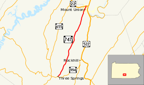
Pennsylvania Route 747 (PA 747) is a 15.28-mile-long (24.59 km) state highway located in Huntingdon and Mifflin counties in Pennsylvania. The southern terminus is at PA 994 in Three Springs. The northern terminus is at US 22 in Mount Union.
Route description
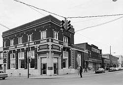
Eastward along PA 747 from the Jefferson Street intersection in downtown Mount Union
PA 747 begins at an intersection with PA 994 in Three Springs, Huntingdon County, heading northeast on two-lane undivided Church Street. The road passes homes before becoming an unnamed road and passing through farmland with some homes. The route briefly passes through Clay Township before heading into Cromwell Township and running north-northeast through wooded areas with some fields and homes. PA 747 continues through a narrow agricultural valley to the east of Jacks Mountain that contains some wooded areas and residences, passing through Cora before crossing into Shirley Township. In this area, the road continues through more of the rural valley. Farther north, the route becomes Hill Valley Road and passes through more rural areas prior to reaching Mount Union. At this point, PA 747 becomes South Division Street and passes homes. The route turns northwest onto West Shirley Street and runs through the downtown area, turning northeast onto North Jefferson Street. The road heads past homes and businesses, crossing an abandoned railroad line and passing under a Norfolk Southern railroad line. The route passes through more residential areas and turns to the north.[2][3] PA 747 crosses the Juniata River into Wayne Township in Mifflin County and ends at an intersection with US 22.[2][4]
Major intersections
See also
 U.S. Roads portal
 Pennsylvania portal
References
Route map: Bing / Google
Template:Attached KML/Pennsylvania Route 747
KML is from Wikidata