U.S. Route 22 in Pennsylvania
| ||||
|---|---|---|---|---|
_map.png) | ||||
| Route information | ||||
| Maintained by PennDOT & DRJTBC | ||||
| Length: | 337.60 mi[1] (543.31 km) | |||
| Existed: | 1926 – present | |||
| Major junctions | ||||
| West end: |
| |||
|
| ||||
| East end: |
| |||
| Location | ||||
| Counties: | Washington, Allegheny, Westmoreland, Indiana, Cambria, Blair, Huntingdon, Mifflin, Juniata, Perry, Dauphin, Lebanon, Berks, Lehigh, Northampton | |||
| Highway system | ||||
| ||||

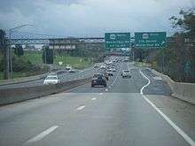
U.S. Route 22 (US 22) is an east–west route stretching from Cincinnati, Ohio in the west to Newark, New Jersey in the east. In Pennsylvania, the route runs for 337.60 miles (543.31 km) between the West Virginia state line at Washington County, where it is a limited-access expressway-grade route through the western suburbs of Pittsburgh, to the New Jersey state line at Easton.
Route description
US 22 carries multiple names as it progresses across the state, including the William Penn Highway and the Lehigh Valley Thruway. Several sections of the road are freeway, including the Lehigh Valley Thruway.
US Route 22 crosses into Pennsylvania from West Virginia as the William Penn Highway. It becomes concurrent with U.S. Route 30 (The Lincoln Highway from Times Square) and then west of Pittsburgh also with I-376, as the Penn Lincoln Parkway. It continues as such through Pittsburgh and beyond the end of the US 30 concurrency, and when I-376 reaches its eastern end at the Pennsylvania Turnpike junction with Interstate 70, US 22 resumes as the William Penn Highway again (with Murrysville as a control city on signs) as it begins the long climb eastwards up the Allegheny Plateau towards the gaps of the Allegheny Front, where it crosses the eastern continental divide in Tunnelhill, Pennsylvania where it descends along the same valley (Blair Gap) once used by the historic Allegheny Portage Railroad. During the last part of its eastbound ascent, it becomes known as the Admiral Peary Highway from Armagh, Pennsylvania in Indiana County through the Blair Gap and down into the Altoona area. From Duncansville to Mount Union, US 22 is a two-lane road with occasional passing and truck-climbing lanes, and it passes through the business district of Huntingdon, where it is three lanes (one lane each way with a turning lane in the middle). It becomes concurrent with US 522 near Mount Union and remains a two-lane road. The US 522 concurrency continues until Lewistown. US 22 bypasses the downtown area of Lewistown as a four-lane limited access highway and becomes concurrent with US 322, continuing as a four-lane limited access highway along the Juniata and Susquehanna rivers until Harrisburg. In Harrisburg (with the US 322 concurrency ending at I-81), it continues as N Cameron Street, Arsenal Blvd., Herr St., Walnut St., Jonestown Rd., and Allentown Blvd. In Fredericksburg, US 22 becomes concurrent with I-78 for a 40-mile (64 km) stretch before splitting off on to the Lehigh Valley Thruway.
Lehigh Valley Thruway
The Lehigh Valley Thruway is a 24-mile-long (39 km) freeway portion of US 22 from the eastern end of the Interstate 78/US 22 concurrency in Kuhnsville, west of Allentown, to the state line in Easton. The highway travels just to the north of Allentown and Bethlehem and passes through Easton. Originally, I-78 would have continued with the U.S. 22 concurrency on the Lehigh Valley Thruway into New Jersey, with I-278 running south as a bypass, and I-178 and I-378 serving Allentown and Bethlehem respectively. Due to opposition in Phillipsburg, New Jersey on the building of a I-78/U.S. 22 highway through the town (the same opposition that later killed the Somerset Freeway for I-95 in 1982), PennDOT and NJDOT decided to reroute the I-78 highway onto the proposed I-278 bypass and allow U.S. 22 to remain on the limited-access highway, which, after going through a series of sharp, potentially dangerous curves in Easton and crossing the Delaware River into NJ, becomes an at-grade divided highway in Phillipsburg. Traffic on the Lehigh Valley Thruway is often heavy at rush hour, particularly near the PA 145 interchange. The series of sharp curves is locally known as "Cemetery Curve", and because of it, the speed limit is lowered to 45 mph at Route 248 and then lowered to 35 mph around the sharpest part of the curves. At the interchange with Bushkill Street, US 22 becomes an elevated highway until crossing into New Jersey. The speed limit drops once again to 25 mph while crossing the Easton-Phillipsburg Toll Bridge.
History
The William Penn Highway was organized as an alternative to the Lincoln Highway being parallel to the Pennsylvania Railroad west of Harrisburg. The route's New York Extension was adopted in 1916. The Pennsylvania Department of Highways assigned the Pennsylvania Route 3 designation to this road in 1924, and in 1926 it became part of U.S. Route 22 when the United States Highway System was formed,[2] The road became problematic for motorists in Lebanon along the current U.S. Route 422; Reading via U.S. Routes 22 and 222; and Allentown on Hamilton Street (US 22).[3] The highway continued through Allentown on Hanover Avenue and through Bethlehem on Broad Street, Linden Street, and Easton Avenue.
Pennsylvania Route 43 was aligned as a bypass, north of the Pennsylvania Dutch Country, that ran from U.S. Route 22, U.S. Route 11, and Pennsylvania Route 5 in Harrisburg to Pennsylvania Route 12 in Bethlehem.[4] The route from Fogelsville to Allentown, now Main Street, Tilghman Street, Broadway, College Heights Boulevard, and Liberty Street, was designated LR 443 in 1925,[5] and was soon incorporated into "Traffic Route 43."[6] The New York Times was recommending use of this cutoff by early 1931.[6] On June 8, 1931, the American Association of State Highway Officials came to a resolution for the traffic problem, by replacing the PA 43 corridor with US 22. The Pennsylvania Department of Highways moved the William Penn Highway name to match.[2][3] The state truncated PA 43 to Susquehanna Street from Allentown to Bethlehem.[4][7][8][9] Signs were changed to reflect the new designations on May 31, 1932, with the new route designations officially in place on June 1, 1932.[10]
Tilghman Street was eventually connected directly from Cetronia to Allentown by a bridge over Cedar Creek; Tilghman Street (west of the Lehigh River) and Union Boulevard (east of the river) were joined in 1929 by a bridge. By 1936, US 22 had been moved from its Hamilton Street and Broad Street alignment to Tilghman Street and Union Boulevard through Allentown and Bethlehem. When the Lehigh Valley Thruway was completed in 1954, US 22 was moved onto it. With the completion of Interstate 78, US 22 was moved onto that highway from Fredericksburg to Kuhnsville.
Former alignment
Old U.S. Route 22 is the former PA 43, and the earlier version of the newer, more traveled U.S. Highway 22. It starts in the unincorporated community of Bethel, Pennsylvania of Berks County and ends in Cetronia, just outside the city of Allentown (Lehigh County) where it becomes Main Street and then Tilghman Street. This road, although no longer a major state highway, is well traveled by those who live in the vicinity. It passes through several communities including Shartlesville, Jalappa, West Hamburg, Edenburg, Krumsville, and New Smithville. It also passes through the boroughs of Strausstown, Hamburg and Lenhartsville. Old U.S. Route 22 crosses seven Pennsylvania highways including 501, 419, 183, 61, 143, 737, and 863. Through these different neighborhoods, this road is defined as Old Route 22, Hex Highway, and Shartlesville Road.
From Cetronia east, the old road is State Route 1002 in Lehigh County, comprising Tilghman Street and Union Boulevard in Allentown. In Northampton County, the 1940s highway is Union Boulevard, Linden Street, and Easton Avenue in Bethlehem; William Penn Highway between Bethlehem and Easton; and Butler Street, 13th Street, and Northampton Street in Easton.
Future
In 2011, it was announced that plans were being resurrected to widen US 22 from Allentown to Bethlehem. Part of the plan is to reconstruct the Lehigh River Bridge. The plan's cost is between $240 to $320 million.[11]
Major intersections
| County | Location | mi | km | Exit | Destinations | Notes |
|---|---|---|---|---|---|---|
| Washington | Hanover Township | 0.00 | 0.00 | West Virginia border | ||
| 5.3 | 8.5 | |||||
| Smith Township | 9.7 | 15.6 | Bavington | |||
| Robinson Township | 11.4 | 18.3 | Current eastern terminus of PA Toll 576 as of August 2015, PA 576 exit 6 | |||
| Allegheny | North Fayette Township | 12.8 | 20.6 | Northern terminus of PA 980 | ||
| 14.4 | 23.2 | Noblestown | To Pennsylvania Motor Speedway | |||
| 16.0 | 25.7 | Western terminus of US 30 concurrency, northern terminus of PA 978 | ||||
| 17.4 | 28.0 | Hankey Farms | ||||
| 18.4 | 29.6 | Westbound exit and eastbound entrance, western terminus of Orange Belt concurrency | ||||
| 19.5 | 31.4 | Montour Church Road, Old Steubenville Pike, Bayer Road | Westbound exit and eastbound entrance | |||
| Robinson Township | 19.9 | 32.0 | Western terminus of I-376 concurrency, exit 60A from I-376, eastern terminus of Orange Belt concurrency | |||
| 20.4 | 32.8 | 60B | ||||
| 20.7 | 33.3 | 61 | Ridge Road | |||
| 21.9 | 35.2 | 62 | Westbound exit and eastbound entrance | |||
| Collier Township | 23.5 | 37.8 | 64A | I-79 exit 59 | ||
| Rosslyn Farms | 24.3 | 39.1 | 64B | Rosslyn Farms | Westbound exit and eastbound entrance | |
| Carnegie | 24.8 | 39.9 | Buses only (West Busway) | Eastbound exit and westbound entrance | ||
| 25.2 | 40.6 | 65 | ||||
| Green Tree | 27.0 | 43.5 | 67 | |||
| Pittsburgh | 27.6 | 44.4 | 68 | Parkway Center Drive | Westbound exit and eastbound entrance | |
| 28.2 | 45.4 | 69A | Western termini of US 19/US 19 Truck concurrencies; eastbound exit is via exit 69C | |||
| 28.7 | 46.2 | 69B | Westbound exit is via exit 69A | |||
| 28.7 | 46.2 | 69C | Eastern terminus of US 19 concurrency; eastbound exit and westbound entrance | |||
| 29.1 | 46.8 | Fort Pitt Tunnel under Mount Washington | ||||
| 29.6 | 47.6 | 69C | Westbound exit and eastbound entrance | |||
| Monongahela River | 29.7 | 47.8 | Fort Pitt Bridge | |||
| Pittsburgh | 29.7 | 47.8 | 70A | Boulevard of the Allies, Liberty Avenue – Consol Energy Center | Eastbound exit and westbound entrance | |
| 29.7 | 47.8 | 70B | Fort Duquesne Boulevard – Convention Center, Strip District | Eastbound exit and westbound entrance | ||
| 29.7 | 47.8 | 70C | Eastern terminus of US 19 Truck concurrency | |||
| 30.0 | 48.3 | 70D | Stanwix Street | No eastbound exit | ||
| 30.4 | 48.9 | 71A | Grant Street | |||
| 30.9 | 49.7 | 71B | Second Avenue | Westbound exit only | ||
| 31.8 | 51.2 | 72A | Forbes Avenue – Oakland | Eastbound exit and westbound entrance | ||
| 32.1 | 51.7 | 72B | Westbound exit and eastbound entrance, access to I-579 and Liberty Bridge is via Boulevard of the Allies | |||
| 32.6 | 52.5 | 73 | Westbound exit and eastbound entrance; signed as exits 73A (south) and 73B (north) | |||
| 34.2 | 55.0 | 74 | ||||
| 34.8 | 56.0 | Squirrel Hill Tunnel under Squirrel Hill | ||||
| Swissvale | 36.4 | 58.6 | 77 | Edgewood, Swissvale | ||
| Wilkinsburg | 37.7 | 60.7 | 78A | Eastern terminus of US 30 concurrency; no westbound exit | ||
| 37.9 | 61.0 | 78B | Southern terminus of PA 8 | |||
| Churchill | 38.6 | 62.1 | 79A | Greensburg Pike | Eastbound exit and westbound entrance | |
| 39.1 | 62.9 | 79B | ||||
| 39.9 | 64.2 | 80 | Eastbound exit and westbound entrance | |||
| Penn Hills | 40.2 | 64.7 | 81 | |||
| Monroeville | 43.8 | 70.5 | 84A | Eastbound exit and westbound entrance, northern terminus of PA 48 | ||
| 44.0 | 70.8 | 84B | Eastbound exit and westbound entrance | |||
| 44.3 | 71.3 | Westbound exit and eastbound entrance | ||||
| 44.3 | 71.3 | Eastern terminus of I-376, I-76 / Penna Turnpike exit 57 (Pittsburgh) | ||||
| 44.5 | 71.6 | East end of freeway | ||||
| 46.4 | 74.7 | Eastbound exit and westbound entrance, westbound exit and eastbound entrance provided by at-grade intersection, western terminus of PA 286 | ||||
| Westmoreland | Salem Township | 54.8 | 88.2 | Single-point urban interchange | ||
| 57.4 | 92.4 | |||||
| New Alexandria | 61.8 | 99.5 | Western terminus of US 119 concurrency | |||
| 62.8 | 101.1 | |||||
| Derry Township | 67.3 | 108.3 | Northern terminus of PA 982 | |||
| Indiana | 71.5 | 115.1 | Interchange | |||
| Burrell Township | 74.2 | 119.4 | Interchange, eastern terminus of US 119 concurrency, to Indiana University of Pennsylvania | |||
| West Wheatfield Township | 80.3 | 129.2 | Interchange | |||
| East Wheatfield Township | 84.4 | 135.8 | Interchange | |||
| 85.6 | 137.8 | Interchange | ||||
| Cambria | Jackson Township | 95.2 | 153.2 | Interchange | ||
| Ebensburg | 99.5 | 160.1 | Interchange | |||
| 100.9 | 162.4 | High Street | Interchange | |||
| 102.8 | 165.4 | Western terminus of freeway | ||||
| 102.8 | 165.4 | Ebensburg, Loretto (Rowena Drive) | ||||
| Munster Township | 105.9 | 170.4 | Northern terminus of PA 164 | |||
| Cresson Township | 109.0 | 175.4 | ||||
| 111.1 | 178.8 | William Penn Highway – Summit | ||||
| Blair | Allegheny Township | 112.8 | 181.5 | Tunnelhill Road – Tunnelhill, Gallitzin | ||
| 119.2 | 191.8 | I-99 / US 220 exit 28 | ||||
| 120.2 | 193.4 | Western terminus of PA 764 concurrency | ||||
| 120.2 | 193.4 | Eastern terminus of freeway | ||||
| 121.8 | 196.0 | Eastern terminus of PA 764 concurrency | ||||
| Hollidaysburg | 124.6 | 200.5 | ||||
| Catharine Township | 136.3 | 219.4 | Northern terminus of PA 866 | |||
| Huntingdon | Morris Township | 142.0 | 228.5 | Southern terminus of PA 453 | ||
| Alexandria | 144.6 | 232.7 | Western terminus of PA 305 | |||
| Huntingdon | 150.2 | 241.7 | Interchange | |||
| Mill Creek | 156.4 | 251.7 | Northern terminus of PA 829 | |||
| 157.2 | 253.0 | Western terminus of PA 655 concurrency | ||||
| Brady Township | 158.6 | 255.2 | Eastern terminus of PA 655 concurrency | |||
| Mifflin | Wayne Township | 163.1 | 262.5 | Northern terminus of PA 747 | ||
| 163.5 | 263.1 | Western terminus of US 522 concuurency | ||||
| Lewistown | 182.2 | 293.2 | Western terminus of freeway | |||
| 182.2 | 293.2 | Western terminus of Business US 22 | ||||
| 186.2 | 299.7 | Western terminus of US 322 concurrency | ||||
| 186.4 | 300.0 | Electric Avenue | ||||
| 187.0 | 300.9 | Eastern terminus of US 522 concurrency | ||||
| 187.4 | 301.6 | East Charles Street | Eastbound exit and westbound entrance | |||
| 189.3 | 304.6 | Westbound exit and eastbound entrance, eastern terminus of Business US 22 | ||||
| Juniata | Fermanagh Township | 196.9 | 316.9 | Arch Rock Road | ||
| 200.1 | 322.0 | To Mifflintown Airport | ||||
| Walker Township | 202.0 | 325.1 | Northern terminus of PA 75 | |||
| Delaware Township | 209.6 | 337.3 | ||||
| 211.2 | 339.9 | Pfoutz Valley Road | Westbound exit and eastbound entrance | |||
| Perry | Greenwood Township | |||||
| Howe Township | ||||||
| Buffalo Township | Midway | Westbound exit and eastbound entrance | ||||
| Watts Township | Watts | |||||
| Amity Hall | ||||||
| Dauphin | Reed Township | |||||
| Eastern terminus of freeway | ||||||
| Eastern terminus of PA 849, no access from PA 849 to US 22/322 westbound | ||||||
| Western terminus of freeway | ||||||
| Susquehanna River | Clarks Ferry Bridge | |||||
| Reed Township | Southern terminus of PA 147 | |||||
| Western terminus of PA 325 | ||||||
| Dauphin | Southern terminus of PA 225 | |||||
| Middle Paxton Township | Dauphin Borough, Stony Creek | Westbound exit | ||||
| Heckton | Eastbound exit | |||||
| Susquehanna Township | ||||||
| I-81 exit 67 | ||||||
| Eastern terminus of US 322 concurrency, I-81 exit 67 | ||||||
| East end of freeway | ||||||
| Harrisburg | Western terminus of PA 230 | |||||
| Lower Paxton Township | I-83 / US 322 exit 50 | |||||
| West Hanover Township | ||||||
| East Hanover Township | ||||||
| Lebanon | East Hanover Township | Interchange | ||||
| Union Township | Cloverleaf interchange | |||||
| Bethel Township | Western terminus of PA 343 concurrency | |||||
| Eastern terminus of PA 343 concurrency | ||||||
| Local Traffic | Old US 22 (Hex Highway) | |||||
| Western terminus of freeway | ||||||
| Western terminus of I-78 concurrency, I-78 exit 8 | ||||||
| Berks | Bethel Township | 10 | ||||
| Bethel | 13 | |||||
| Bethel Township | 15 | Grimes | No access across I-78/US 22, no tractor trailers | |||
| 16 | Midway | To Conrad Weiser Homestead | ||||
| 17 | ||||||
| Strausstown | 19 | |||||
| Upper Bern Township | 23 | Shartlesville | ||||
| Tilden Township | 29 | Signed as exits 29A (south) and 29B (north) on the westbound side | ||||
| Hamburg | 30 | Hamburg | ||||
| Greenwich Township | 35 | |||||
| 40 | To Kutztown University | |||||
| Lehigh | Weisenberg Township | 45 | ||||
| Upper Macungie Township | 49 | Split into exits 49A (south) and 49B (north) | ||||
| Eastbound exit and westbound entrance, eastern terminus of I-78 concurrency, I-78 exit 51 | ||||||
| Cetronia, Kuhnsville | Access via SR 1002 (Tilghman Street), former routing of US 22 through Allentown | |||||
| South Whitehall Township | I-476 / Penna Turnpike NE Extension exit 56 (Lehigh Valley) | |||||
| Cloverleaf interchange, To I-78 east, Dorney Park & Wildwater Kingdom, and Lehigh Carbon Community College | ||||||
| Cedar Crest Boulevard | To Muhlenberg College and Cedar Crest College | |||||
| 15th Street | ||||||
| Whitehall Township | To Allentown Center City, Lehigh Valley Mall, and Whitehall Mall | |||||
| Fullerton Avenue | ||||||
| Hanover Township | Cloverleaf interchange, southern terminus of PA 987 | |||||
| Bethlehem | Northern terminus of PA 378, to Lehigh University, Historic Bethlehem, Sands Casino Resort; Formerly I-378 | |||||
| Northampton | Schoenersville Road | |||||
| Hanover Township | Southern terminus of PA 512, to Moravian College | |||||
| Bethlehem Township | Southern terminus of PA 191, to Northampton Community College | |||||
| Palmer Township | To Palmer Heights and Easton | |||||
| Easton | 13th Street | |||||
| Eastbound exit and westbound entrance | ||||||
| 3rd Street / Snyder Street – Easton, Lafayette College | Westbound exit and eastbound entrance | |||||
| Westbound exit and eastbound entrance | ||||||
| Delaware River | Easton-Phillipsburg Toll Bridge (Westbound toll, cash or E-ZPass) | |||||
| Continuation into New Jersey | ||||||
1.000 mi = 1.609 km; 1.000 km = 0.621 mi
| ||||||
See also
 U.S. Roads portal
 Pennsylvania portal
 Pittsburgh portal
References
- ↑ DeLorme Street Atlas USA 2007 software, Driving Directions
- 1 2 "William Penn Highway: US 22 in Pennsylvania". Federal Highway Administration. Retrieved 2007-06-26.
- 1 2 Butko, Brian A.; Kevin Joseph Patrick (1999). Diners of Pennsylvania. Stackpole Books. ISBN 0-8117-2878-1.
- 1 2 1930 state map, front side (PDF) (Map). Pennsylvania Department of Highways. Retrieved 2007-06-26.
- ↑ Public Law 191, passed April 8, 1925
- 1 2 Dickinson, Leon A. (February 1, 1931). "Highways Into the Deep South". New York Times. p. 136. Retrieved 2009-08-14.
Here one meets and follows U.S. Route 22 through Bethlehem to Allentown; then along Route 43 direct to Harrisburg.
- ↑ Allentown Area Map (Map). Pennsylvania Department of Highways. 1929. Retrieved 2007-07-24.
- ↑ State Map, back side (PDF) (Map). Pennsylvania Department of Highways. 1930. Retrieved 2007-07-24.
- ↑ 1941 Lehigh County Map (PDF) (Map). Pennsylvania Department of Highways. Retrieved 2007-06-25.
- ↑ "U.S. Route 22 Through Reading Changed to 222". Reading Times. June 1, 1932. p. 14. Retrieved August 7, 2015 – via Newspapers.com.

- ↑ Express-Times File Photo. "Route 22 widening back in play as commission finds new funding sources, officials say". lehighvalleylive.com. Retrieved 2012-08-17.
External links
| Wikimedia Commons has media related to U.S. Route 22 in Pennsylvania. |
| Previous state: West Virginia |
Pennsylvania | Next state: New Jersey |