Saltillo, Pennsylvania
| Saltillo, Pennsylvania | |
|---|---|
| Borough | |
|
| |
 Saltillo, Pennsylvania | |
| Coordinates: 40°12′39″N 78°0′20″W / 40.21083°N 78.00556°WCoordinates: 40°12′39″N 78°0′20″W / 40.21083°N 78.00556°W | |
| Country | United States |
| State | Pennsylvania |
| County | Huntingdon |
| Government | |
| • Type | Borough Council |
| Area | |
| • Total | 0.3 sq mi (0.8 km2) |
| Population (2000) | |
| • Total | 343 |
| • Density | 1,112.6/sq mi (429.6/km2) |
| Time zone | Eastern (EST) (UTC-5) |
| • Summer (DST) | EDT (UTC-4) |
| Zip code | 17253 |
| Area code(s) | 814 |
| School District: | Southern Huntingdon County School District |
| Local phone exchanges: 447, 448 | |
Saltillo is a borough in Huntingdon County, Pennsylvania, United States. The population was 343 at the 2000 census.
History
Saltillo was named after the Mexican War Battle of Saltillo (23 October 1840). It was a major tanning center during the late 18th and early 19th century. The Leas and McVitty Tannery was located here, a tannery known for quality hides. The main line of the East Broad Top Railroad and Coal Company was built through Saltillo in 1874. The railroad serviced the tannery as well as a short lived iron mine and an equally short lived limestone quarry, both just southeast of town. Saltillo was an important place on the EBT acting as a base station for the long grade up to Broad Top Mountain. The EBT had a three track yard, a station, a water tank and a turning wye located here. Just after the turn of the 20th century a large Ganister quarry was established above Saltillo on Jacks Mountain by Mount Union Refractories (later United States Refractories and North American Refractories) to supply their plant in Mount Union, Pennsylvania. In 1942 a spur was built from the EBT yard in Saltillo which climbed the mountain to a tipple below the quarry. The branch was the steepest track on the EBT and remained in service until the line closed in 1956. The quarry continued to operate into the 1970s, serviced by trucks. Saltillo was also the location of a grist mill which still exists at the southwest edge of town.
The EBT tracks on Saltillo are still in place. The water tank was burned by vandals in the late 1980s and the station was demolished in the mid-2000s after being allowed to deteriorate to deplorable condition.
Around 1935 the skeleton of a mastodon was discovered behind the ball field in Saltillo by two young men digging a drainage ditch. They excavated several bones, teeth and both tusk. Then gave them to C.R. Cornelius the lands owner, who later donated them to Penn State University where they can be seen today. In the 1990s Penn State reopened the dig and found even more bones that were missed during the first excavation.
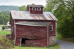
The Hudson Grist Mill was listed on the National Register of Historic Places in 1990.[1]
Geography
Saltillo is located at 40°12′39″N 78°00′21″W / 40.2109°N 78.0057°W.[2]
According to the United States Census Bureau, the borough has a total area of 0.3 square miles (0.78 km2), all of it land.
Demographics
| Historical population | |||
|---|---|---|---|
| Census | Pop. | %± | |
| 1880 | 227 | — | |
| 1890 | 254 | 11.9% | |
| 1900 | 377 | 48.4% | |
| 1910 | 410 | 8.8% | |
| 1920 | 418 | 2.0% | |
| 1930 | 386 | −7.7% | |
| 1940 | 433 | 12.2% | |
| 1950 | 435 | 0.5% | |
| 1960 | 395 | −9.2% | |
| 1970 | 341 | −13.7% | |
| 1980 | 373 | 9.4% | |
| 1990 | 347 | −7.0% | |
| 2000 | 343 | −1.2% | |
| 2010 | 346 | 0.9% | |
| Est. 2015 | 345 | [3] | −0.3% |
| Sources:[4][5][6] | |||
As of the census[5] of 2000, there were 343 people, 135 households, and 100 families residing in the borough. The population density was 1,112.6 people per square mile (427.2/km2). There were 152 housing units at an average density of 493.1 per square mile (189.3/km2). The racial makeup of the borough was 99.13% White, 0.58% African American, and 0.29% from two or more races.
There were 135 households, out of which 34.8% had children under the age of 18 living with them, 67.4% were married couples living together, 4.4% had a female householder with no husband present, and 25.2% were non-families. 22.2% of all households were made up of individuals, and 11.9% had someone living alone who was 65 years of age or older. The average household size was 2.54 and the average family size was 3.01.
In the borough the population was spread out, with 27.7% under the age of 18, 5.8% from 18 to 24, 33.5% from 25 to 44, 18.1% from 45 to 64, and 14.9% who were 65 years of age or older. The median age was 34 years. For every 100 females there were 101.8 males. For every 100 females age 18 and over, there were 103.3 males.
The median income for a household in the borough was $32,917, and the median income for a family was $40,000. Males had a median income of $28,750 versus $16,250 for females. The per capita income for the borough was $14,333. About 5.4% of families and 7.8% of the population were below the poverty line, including 10.3% of those under age 18 and 3.3% of those age 65 or over.
References
- ↑ National Park Service (2010-07-09). "National Register Information System". National Register of Historic Places. National Park Service.
- ↑ "US Gazetteer files: 2010, 2000, and 1990". United States Census Bureau. 2011-02-12. Retrieved 2011-04-23.
- ↑ "Annual Estimates of the Resident Population for Incorporated Places: April 1, 2010 to July 1, 2015". Retrieved July 2, 2016.
- ↑ "Census of Population and Housing". U.S. Census Bureau. Retrieved 11 December 2013.
- 1 2 "American FactFinder". United States Census Bureau. Retrieved 2008-01-31.
- ↑ "Incorporated Places and Minor Civil Divisions Datasets: Subcounty Resident Population Estimates: April 1, 2010 to July 1, 2012". Population Estimates. U.S. Census Bureau. Retrieved 11 December 2013.
Municipalities and communities of Huntingdon County, Pennsylvania, United States | ||
|---|---|---|
| Boroughs | 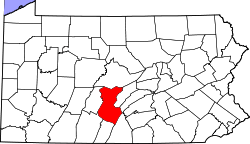 | |
| Townships | ||
| CDPs | ||
| Unincorporated communities | ||