Pennsylvania Route 291
| ||||
|---|---|---|---|---|
 | ||||
| Route information | ||||
| Maintained by PennDOT | ||||
| Length: | 14.014 mi[1] (22.553 km) | |||
| Existed: | 1928 – present | |||
| Major junctions | ||||
| West end: |
| |||
|
| ||||
| East end: |
| |||
| Location | ||||
| Counties: | Delaware, Philadelphia | |||
| Highway system | ||||
| ||||

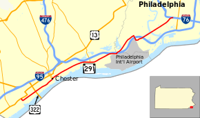
Pennsylvania Route 291 (PA 291) is an east–west route in Pennsylvania that runs from U.S. Route 13 (US 13) in Trainer, Delaware County east to Interstate 76 (I-76) in South Philadelphia near the Walt Whitman Bridge and the South Philadelphia Sports Complex. Except for a short 1-mile (1.6 km) section between US 13 and the Chester/Trainer line, PA 291 is mostly a four-lane highway. It runs parallel to the Delaware River. The route passes through industrial areas near the river in Delaware County, serving Chester, Eddystone, Essington, and Lester. PA 291 enters Philadelphia near the Philadelphia International Airport, at which point it interchanges with I-95. The route crosses the Schuylkill River on the George C. Platt Memorial Bridge and continues along Penrose Avenue to I-76.
PA 291 was first designated by 1928 along an unpaved road between PA 420 in Prospect Park and PA 191. The route was extended west to US 13 in Eddystone by 1930 on a paved road. PA 291 was realigned to run from US 13 in Trainer to PA 420 in Essington by 1940. The route was extended to US 1/US 13/US 30/US 611 at Broad Street and Spring Garden Street north of Center City Philadelphia by 1950. By 1960, PA 291 was realigned from Essington Avenue and Passyunk Avenue to Penrose Avenue and Broad Street. In the 1960s, the northern terminus was moved to US 30 and US 611 at Vine Street. In the 1970s, the north end was cut back to PA 611 at Philadelphia City Hall. A freeway was proposed along the PA 291 corridor between I-95 and I-76 from 1950 until the 1970s, when it was cancelled due to funding issues. The northern terminus was moved to its current location by 1989, with an extended PA 611 replacing PA 291 on Broad Street. Around 2000, the route was rebuilt as a five-lane road in Chester. PA 291 was realigned to bypass the Philadelphia International Airport in 2006.
Route description
Delaware County
PA 291 begins at an intersection with US 13 near a ConocoPhillips oil refinery in Trainer, Delaware County, heading southeast on two-lane undivided Price Street. The road passes between homes to the northeast and industrial areas to the southwest. The route makes a sharp curve to the northeast and becomes 2nd Street, crossing into Chester and passing through urban residential and industrial areas. PA 291 continues northeast and becomes a five-lane road with a center left-turn lane as it passes more urban development and empty lots. The route comes to ramps that provide access from the eastbound direction of US 322 and to the westbound direction of US 322 just northwest of where that route crosses the Delaware River on the Commodore Barry Bridge. The road passes under the western approach of the Commodore Barry Bridge carrying US 322.[2][3]
Following this, PA 291 passes more urban homes and businesses. The route splits from 2nd Street and continues northeast as an unnamed road, crossing Chester Creek near Chester's City Hall and the William Penn Landing Site. PA 291 intersects the southern terminus of Pennsylvania Route 320 (Madison Street northbound and Upland Street southbound), at which point it becomes 4th Street. The road continues through commercial areas and intersects Morton Avenue, which connects to US 13 to the north. At this point, the route runs between Amtrak's Northeast Corridor to the northwest and the SCI Chester prison to the southeast before intersecting a road providing access to Harrah's Philadelphia to the southeast along the Delaware River. The road continues northeast between the Amtrak Northeast Corridor to the northwest and Conrail Shared Assets Operations' Stoney Creek Secondary to the southeast, crossing the Ridley Creek out of Chester and into Eddystone.[2][3]
.JPG)
Here, PA 291 becomes Industrial Highway, a four-lane divided highway, and continues east, with the Northeast Corridor line heading northeast away from the highway. The road continues through industrial areas, passing to the north of Exelon's Eddystone Generation Facility. The route crosses the Crum Creek into Ridley Township and passes through Boeing's Helicopter Facility. In this area, PA 291 intersects Stewart Avenue, which heads north to an interchange with I-95. Past this, the Stoney Creek Secondary heads farther south from the road as it passes more commercial establishments. The route crosses the Darby Creek into Tinicum Township and runs east past more businesses, intersecting the southern terminus of PA 420 to the north of Essington.[2][3]
Past this intersection, PA 291 continues east through commercial areas with some homes, becoming Governor Printz Boulevard. The route heads northeast into the community of Lester, where it splits into the one-way pair of South Governor Printz Boulevard eastbound and North Governor Printz Boulevard westbound, carrying two lanes in east direction and passing more development. The two directions rejoin as a four-lane divided highway with a wide median that runs near commercial establishments, coming to a ramp from northbound I-95 to eastbound PA 291 that merges in from the left. From here, the route continues east as a four-lane divided highway between I-95 to the north and a lake to the south, coming to a bridge over the Stoney Creek Secondary. At this point, PA 291 reaches the Philadelphia International Airport, where it turns north onto four-lane divided Bartram Avenue and crosses under I-95.[2][3]
Philadelphia
After crossing under I-95, PA 291 enters Philadelphia and curves to the northeast, running parallel to the Stoney Creek Secondary to the northwest. The road passes under SEPTA's Airport Line leading to the airport at which point that railroad line merges with the Stoney Creek Secondary. The route continues northeast parallel to the Airport Line, coming to a partial interchange with I-95 that has ramps to and from the southbound lanes of I-95. PA 291 passes to the northwest of business parks and hotels before it curves away from the railroad tracks and passes to the north of an airport employee parking lot, intersecting 84th Street. The route turns south onto two-lane undivided Island Avenue and passes under I-95 again, with a ramp to southbound I-95. On the edge of the Philadelphia International Airport property, PA 291 turns east onto six-lane undivided Penrose Avenue and passes more businesses, coming to an interchange with I-95. Past this interchange, the route becomes four lanes and ascends onto the George C. Platt Memorial Bridge, passing near industrial areas before crossing over the Schuylkill River.[2][4]
After crossing the river, the bridge passes over part of a large Sunoco oil refinery. After descending off the bridge, the route continues as four-lane divided Penrose Avenue near industrial areas. PA 291 intersects South 26th Street, which heads north to provide access to westbound I-76 (Schuylkill Expressway) and from eastbound I-76. Past this intersection, the road passes under CSX's Harrisburg Subdivision before becoming a five-lane road with a center left-turn lane and passing homes and businesses in South Philadelphia. PA 291 reaches its eastern terminus at an interchange with I-76, with access to the eastbound lanes of I-76 and from the westbound lanes of I-76. Past this, the road continues northeast as Moyamensing Avenue.[2][4]
History
When Pennsylvania first legislated routes in 1911, what would become PA 291 was not legislated as part of any route.[5] PA 291 was first designated by 1928 to run from PA 420 in Prospect Park east to PA 191 along an unpaved road.[6] By 1930, PA 291 was extended west to US 13 in Eddystone, following PA 420 south for a short concurrency before continuing west along its current alignment. The extended alignment of PA 291 was a paved road.[7] By 1940, PA 291 was realigned to run from US 13 in Trainer east to PA 420 near Essington. The former alignment east of PA 420 became an unnumbered road.[8]
PA 291 was extended northeast to US 1/US 13/US 30/US 611 at the intersection of Broad Street and Spring Garden Street north of Center City Philadelphia by 1950, following the newly built Industrial Highway in Tinicum Township before heading along Essington Avenue, Passyunk Avenue, and Broad Street in Philadelphia. The route replaced PA 191 along Broad Street between Passyunk Avenue and Spring Garden Street.[9] By 1960, PA 291 was realigned at the Airport Circle between Essington Avenue and Penrose Avenue in Philadelphia to follow Penrose Avenue, Moyamensing Avenue, and Broad Street toward Center City Philadelphia. This section replaced the PA 191 designation along Penrose Avenue and Broad Street between Essington Avenue and Passyunk Avenue.[10] In the 1960s, the northern terminus was cut back to US 30 and US 611 at Vine Street, with US 611 replacing PA 291 along Broad Street between Vine and Spring Garden streets.[11] After US 611 was decommissioned in 1971, the northern terminus of PA 291 was cut back to PA 611 at Philadelphia City Hall; PA 611 replaced the PA 291 designation between City Hall and Vine Street.[12][13] In the 1970s, the Airport Circle was removed.[14]
In 1950, the Philadelphia City Planning Commission proposed a PA 291 freeway along Penrose Avenue between the Delaware Expressway (I-95) near the Philadelphia International Airport and the Schuylkill Expressway (I-76). The freeway was to split into two alignments leading to I-76: one following South 26th Street to connect to westbound I-76 and the other following Penrose Avenue to connect to eastbound I-76.[15] Plans for the PA 291 freeway were dropped in the 1970s because the Pennsylvania Department of Transportation halted a number of road projects due to funding issues.[16]
The northern terminus of PA 291 was cut back from PA 3 and PA 611 at City Hall to I-76 by 1989. The former portion of PA 291 along Broad Street was replaced by an extended PA 611.[17] In 1999, PA 291 was realigned in Chester to a new five-lane alignment that connected 2nd Street and 4th Street to improve travel for trucks and attempt to revitalize Chester. Construction of the new alignment took two years.[18] Before this, PA 291 continued east along 2nd Street and turned north on Crosby Street to reach 4th Street.[19] Expansion of the road to five lanes through the remainder of Chester was slated to be complete in 2001.[18] In 2006, PA 291 was rerouted to use Bartram Avenue and Island Avenue around the Philadelphia International Airport instead of Industrial Highway due to runway expansion at the airport.[20] In May 2011, a $42 million project began to rehabilitate the George C. Platt Memorial Bridge. The project was completed in June 2014.[21]
Major intersections
| County | Location | mi[1] | km | Destinations | Notes |
|---|---|---|---|---|---|
| Delaware | Trainer | 0.000 | 0.000 | ||
| Chester | 1.387 | 2.232 | Interchange, entrance to westbound US 322 and exit from eastbound US 322 | ||
| 2.985 | 4.804 | Southern terminus of PA 320 | |||
| Tinicum Township | 6.206 | 9.988 | Southern terminus of PA 420 | ||
| 7.760 | 12.489 | Eastbound entrance from exit 10 on I-95 | |||
| 8.409 | 13.533 | At-grade intersection | |||
| Philadelphia | Philadelphia | 9.059 | 14.579 | Exit 12 on I-95 | |
| 10.504 | 16.905 | Exit 13 on I-95 | |||
| 11.270 | 18.137 | Westbound exit only | |||
| George C. Platt Memorial Bridge over the Schuylkill River | |||||
| 13.136 | 21.140 | ||||
| 13.376 | 21.527 | ||||
| 14.014 | 22.553 | Eastbound exit and westbound entrance; exit 348 on I-76 | |||
| 14.014 | 22.553 | Penrose Avenue east | Continuation beyond I-76 flyover ramps | ||
| 1.000 mi = 1.609 km; 1.000 km = 0.621 mi | |||||
See also
 U.S. Roads portal
 Pennsylvania portal
 Philadelphia portal
References
- 1 2 Bureau of Maintenance and Operations (January 2015). Roadway Management System Straight Line Diagrams (Report) (2015 ed.). Pennsylvania Department of Transportation. Retrieved June 30, 2015.
- Delaware County (PDF)
- Philadelphia County (PDF)
- 1 2 3 4 5 6 Google (January 17, 2014). "Pennsylvania Route 291" (Map). Google Maps. Google. Retrieved January 17, 2014.
- 1 2 3 4 Delaware County, Pennsylvania Highway Map (PDF) (Map). PennDOT. 2013. Retrieved January 15, 2014.
- 1 2 Philadelphia County, Pennsylvania Highway Map (PDF) (Map). PennDOT. 2013. Retrieved January 17, 2014.
- ↑ Map of Pennsylvania Showing State Highways (PDF) (Map). Pennsylvania Department of Highways. 1911. Retrieved January 1, 2014.
- ↑ Pennsylvania Highway Map (Philadelphia Metro) (Map). Gulf Oil. 1928. Retrieved November 8, 2007.
- ↑ Tourist Map of Pennsylvania (PDF) (Map). Pennsylvania Department of Highways. 1930. Retrieved January 1, 2014.
- ↑ Official Road Map of Pennsylvania (back) (PDF) (Map). Pennsylvania Department of Highways. 1940. Retrieved January 1, 2014.
- ↑ Official Road Map of Pennsylvania (back) (PDF) (Map). Pennsylvania Department of Highways. 1950. Retrieved January 16, 2014.
- ↑ Official Map of Pennsylvania (back) (PDF) (Map). Pennsylvania Department of Highways. 1960. Retrieved January 16, 2014.
- ↑ Official Map of Pennsylvania (back) (PDF) (Map). Pennsylvania Department of Highways. 1970. Retrieved December 16, 2014.
- ↑ U.S. Route Numbering Subcommittee (December 3, 1971). "U.S. Route Numbering Subcommittee Agenda" (PDF) (Report). Miami Beach, FL: American Association of State Highway Officials. p. 418. Retrieved December 18, 2014 – via Wikimedia Commons.
- ↑ Pennsylvania (Map). Cartography by General Drafting. Exxon. 1973.
- ↑ Pennsylvania Official Transportation Map (back) (PDF) (Map). Pennsylvania Department of Transportation. 1980. Retrieved January 17, 2014.
- ↑ Schuylkill Expressway, Roosevelt Boulevard Expressway and Vine Street Expressway (Report). Philadelphia City Planning Commission. 1950.
- ↑ Nussbaum, Paul (August 19, 1984). "Schuylkill Carries the Load of Many Roads Left Unbuilt". The Philadelphia Inquirer.
- ↑ Pennsylvania Official Transportation Map (back) (PDF) (Map). Pennsylvania Department of Transportation. 1989. Retrieved January 17, 2014.
- 1 2 Hardy, Dan (October 8, 1999). "End Of The Road For Construction Construction On Route 291 In Chester Is Finally Complete - For Now. A New Phase Of The Project Is Set To Begin In 2001.". The Philadelphia Inquirer. Retrieved January 17, 2014.
- ↑ Delaware County, Pennsylvania Highway Map (PDF) (Map). PennDOT. 1996. Retrieved January 17, 2014.
- ↑ Belden, Tom (September 30, 2006). "Road near airport to be rerouted". The Philadelphia Inquirer. Retrieved January 17, 2014.
- ↑ "Platt Bridge Project Overview". Pennsylvania Department of Transportation. Retrieved January 17, 2014.
External links
- PennDOT's George C. Platt Memorial Bridge (PA 291/Penrose Ave) Rehabilitation Construction Project
- PA State Route 291 ends
- PA Routes 291-300 - Central PA/MD Roads
- Industrial Expressway (unbuilt)
- Pennsylvania @ NorthEastRoads.com - Pennsylvania 291