Pers, Deux-Sèvres
| Pers | |
|---|---|
|
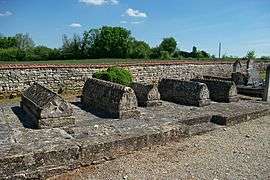
Merovingian tombs in Pers | |
 Pers | |
|
Location within Nouvelle-Aquitaine region  Pers | |
| Coordinates: 46°13′11″N 0°04′02″E / 46.2197°N 0.0672°ECoordinates: 46°13′11″N 0°04′02″E / 46.2197°N 0.0672°E | |
| Country | France |
| Region | Nouvelle-Aquitaine |
| Department | Deux-Sèvres |
| Arrondissement | Niort |
| Canton | Sauzé-Vaussais |
| Intercommunality | Cœur du Poitou |
| Government | |
| • Mayor (2008–2014) | Marie-Claire Guérin |
| Area1 | 4.73 km2 (1.83 sq mi) |
| Population (2006)2 | 72 |
| • Density | 15/km2 (39/sq mi) |
| Time zone | CET (UTC+1) |
| • Summer (DST) | CEST (UTC+2) |
| INSEE/Postal code | 79205 / 79190 |
| Elevation |
127–151 m (417–495 ft) (avg. 151 m or 495 ft) |
|
1 French Land Register data, which excludes lakes, ponds, glaciers > 1 km² (0.386 sq mi or 247 acres) and river estuaries. 2 Population without double counting: residents of multiple communes (e.g., students and military personnel) only counted once. | |
Pers is a commune in the Deux-Sèvres department in western France.
See also
References
| Wikimedia Commons has media related to Pers (Deux-Sèvres). |
This article is issued from Wikipedia - version of the 3/7/2015. The text is available under the Creative Commons Attribution/Share Alike but additional terms may apply for the media files.