Petritoli
| Petritoli | ||
|---|---|---|
| Comune | ||
| Comune di Petritoli | ||
 | ||
| ||
 Petritoli Location of Petritoli in Italy | ||
| Coordinates: 42°6′N 13°49′E / 42.100°N 13.817°E | ||
| Country | Italy | |
| Region | Marche | |
| Province / Metropolitan city | Fermo (FM) | |
| Frazioni | Moregnano, Valmir | |
| Government | ||
| • Mayor | Luca Tomassini | |
| Area | ||
| • Total | 23.8 km2 (9.2 sq mi) | |
| Elevation | 358 m (1,175 ft) | |
| Population (31 October 2009[1]) | ||
| • Total | 2,494 | |
| • Density | 100/km2 (270/sq mi) | |
| Demonym(s) | Petritolesi | |
| Time zone | CET (UTC+1) | |
| • Summer (DST) | CEST (UTC+2) | |
| Postal code | 63027 | |
| Dialing code | 0734 | |
| Patron saint | St. John the Baptist | |
| Saint day | 24 June | |

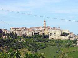
Petritoli is a comune (municipality) in the Province of Fermo in the Italian region Marche, located about 90 kilometres (56 mi) south of Ancona and about 50 kilometres (31 mi) north of Ascoli Piceno.
Petritoli borders the following municipalities: Carassai, Monte Giberto, Monte Vidon Combatte, Montefiore dell'Aso, Monterubbiano, Ponzano di Fermo.
Twin towns
 Vidor, Italy
External links
References
This article is issued from Wikipedia - version of the 11/24/2016. The text is available under the Creative Commons Attribution/Share Alike but additional terms may apply for the media files.