Peyrolles-en-Provence
| Peyrolles-en-Provence | ||
|---|---|---|
|
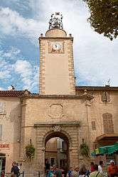
The 17th century bell tower in Peyrolles-en-Provence | ||
| ||
 Peyrolles-en-Provence | ||
|
Location within Provence-A.-C.d'A. region  Peyrolles-en-Provence | ||
| Coordinates: 43°38′47″N 5°35′09″E / 43.6464°N 5.5858°ECoordinates: 43°38′47″N 5°35′09″E / 43.6464°N 5.5858°E | ||
| Country | France | |
| Region | Provence-Alpes-Côte d'Azur | |
| Department | Bouches-du-Rhône | |
| Arrondissement | Aix-en-Provence | |
| Canton | Peyrolles-en-Provence | |
| Intercommunality | Pays d'Aix | |
| Government | ||
| • Mayor (2008–2014) | Danielle Long | |
| Area1 | 34.9 km2 (13.5 sq mi) | |
| Population (2008)2 | 4,477 | |
| • Density | 130/km2 (330/sq mi) | |
| Time zone | CET (UTC+1) | |
| • Summer (DST) | CEST (UTC+2) | |
| INSEE/Postal code | 13074 / 13860 | |
| Elevation |
201–782 m (659–2,566 ft) (avg. 220 m or 720 ft) | |
|
1 French Land Register data, which excludes lakes, ponds, glaciers > 1 km² (0.386 sq mi or 247 acres) and river estuaries. 2 Population without double counting: residents of multiple communes (e.g., students and military personnel) only counted once. | ||
.svg.png)
Peyrolles-en-Provence is a commune in the Bouches-du-Rhône department in southern France.
Population
| Historical population | ||
|---|---|---|
| Year | Pop. | ±% |
| 1793 | 769 | — |
| 1800 | 775 | +0.8% |
| 1806 | 913 | +17.8% |
| 1821 | 1,135 | +24.3% |
| 1831 | 1,171 | +3.2% |
| 1836 | 1,170 | −0.1% |
| 1841 | 1,203 | +2.8% |
| 1846 | 1,159 | −3.7% |
| 1851 | 1,222 | +5.4% |
| 1856 | 1,216 | −0.5% |
| 1861 | 1,260 | +3.6% |
| 1866 | 1,260 | +0.0% |
| 1872 | 1,255 | −0.4% |
| 1876 | 1,194 | −4.9% |
| 1881 | 1,040 | −12.9% |
| 1886 | 1,022 | −1.7% |
| 1891 | 974 | −4.7% |
| 1896 | 1,005 | +3.2% |
| 1901 | 927 | −7.8% |
| 1906 | 886 | −4.4% |
| 1911 | 921 | +4.0% |
| 1921 | 804 | −12.7% |
| 1926 | 811 | +0.9% |
| 1931 | 860 | +6.0% |
| 1936 | 906 | +5.3% |
| 1946 | 1,049 | +15.8% |
| 1954 | 1,199 | +14.3% |
| 1962 | 2,003 | +67.1% |
| 1968 | 2,249 | +12.3% |
| 1975 | 2,297 | +2.1% |
| 1982 | 2,560 | +11.4% |
| 1990 | 2,918 | +14.0% |
| 1999 | 3,914 | +34.1% |
| 2008 | 4,477 | +14.4% |
See also
References
External links
- Official website (in French)
| Wikimedia Commons has media related to Peyrolles-en-Provence. |
This article is issued from Wikipedia - version of the 1/27/2015. The text is available under the Creative Commons Attribution/Share Alike but additional terms may apply for the media files.