Eyguières
| Eyguières | ||
|---|---|---|
|
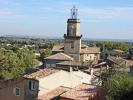
A general view of the village of Eyguières | ||
| ||
 Eyguières | ||
|
Location within Provence-A.-C.d'A. region  Eyguières | ||
| Coordinates: 43°41′43″N 5°01′52″E / 43.6953°N 5.0311°ECoordinates: 43°41′43″N 5°01′52″E / 43.6953°N 5.0311°E | ||
| Country | France | |
| Region | Provence-Alpes-Côte d'Azur | |
| Department | Bouches-du-Rhône | |
| Arrondissement | Arles | |
| Canton | Eyguières | |
| Intercommunality | Salon-Étang de Berre-Durance | |
| Government | ||
| • Mayor (2014–2020) | Henri Pons (PR) | |
| Area1 | 68.75 km2 (26.54 sq mi) | |
| Population (2012)2 | 6,596 | |
| • Density | 96/km2 (250/sq mi) | |
| Time zone | CET (UTC+1) | |
| • Summer (DST) | CEST (UTC+2) | |
| INSEE/Postal code | 13035 / 13430 | |
| Elevation | 63–496 m (207–1,627 ft) | |
|
1 French Land Register data, which excludes lakes, ponds, glaciers > 1 km² (0.386 sq mi or 247 acres) and river estuaries. 2 Population without double counting: residents of multiple communes (e.g., students and military personnel) only counted once. | ||
.svg.png)
Eyguières is a commune in the Bouches-du-Rhône department in southern France.
Population
| Historical population | ||
|---|---|---|
| Year | Pop. | ±% |
| 1793 | 2,300 | — |
| 1800 | 2,668 | +16.0% |
| 1806 | 2,435 | −8.7% |
| 1821 | 2,925 | +20.1% |
| 1831 | 2,987 | +2.1% |
| 1836 | 2,838 | −5.0% |
| 1841 | 2,920 | +2.9% |
| 1846 | 2,992 | +2.5% |
| 1851 | 2,999 | +0.2% |
| 1856 | 2,935 | −2.1% |
| 1861 | 2,999 | +2.2% |
| 1866 | 3,001 | +0.1% |
| 1872 | 3,246 | +8.2% |
| 1876 | 2,771 | −14.6% |
| 1881 | 2,591 | −6.5% |
| 1886 | 2,678 | +3.4% |
| 1891 | 2,368 | −11.6% |
| 1896 | 2,326 | −1.8% |
| 1901 | 2,333 | +0.3% |
| 1906 | 2,267 | −2.8% |
| 1911 | 2,091 | −7.8% |
| 1921 | 1,946 | −6.9% |
| 1926 | 2,021 | +3.9% |
| 1931 | 1,951 | −3.5% |
| 1936 | 2,005 | +2.8% |
| 1946 | 2,013 | +0.4% |
| 1954 | 2,119 | +5.3% |
| 1962 | 2,450 | +15.6% |
| 1968 | 2,742 | +11.9% |
| 1975 | 3,284 | +19.8% |
| 1982 | 4,171 | +27.0% |
| 1990 | 4,481 | +7.4% |
| 1999 | 5,392 | +20.3% |
| 2008 | 6,378 | +18.3% |
See also
References
External links
- Tourism office website (in French and English)
| Wikimedia Commons has media related to Eyguières. |
This article is issued from Wikipedia - version of the 7/2/2015. The text is available under the Creative Commons Attribution/Share Alike but additional terms may apply for the media files.