Pickens, South Carolina
| Pickens, South Carolina | |
|---|---|
| City | |
|
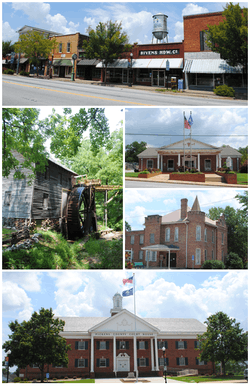
Top, left to right: Downtown Pickens, Hagood Mill, Pickens City Hall, Old Pickens Jail, Pickens County Courthouse | |
| Nickname(s): Where The Mountains Begin | |
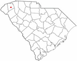 Location of Pickens, South Carolina | |
| Coordinates: 34°52′54″N 82°42′27″W / 34.88167°N 82.70750°WCoordinates: 34°52′54″N 82°42′27″W / 34.88167°N 82.70750°W | |
| Country | United States |
| State | South Carolina |
| County | Pickens |
| Area | |
| • Total | 2.5 sq mi (6.4 km2) |
| • Land | 2.5 sq mi (6.4 km2) |
| • Water | 0.0 sq mi (0.0 km2) |
| Elevation | 1,093 ft (333 m) |
| Population (2000) | |
| • Total | 3,012 |
| • Density | 1,227.1/sq mi (473.8/km2) |
| Time zone | Eastern (EST) (UTC-5) |
| • Summer (DST) | EDT (UTC-4) |
| ZIP code | 29671 |
| Area code(s) | 864 |
| FIPS code | 45-56140[1] |
| GNIS feature ID | 1250078[2] |
| Website | www.cityofpickens.com |
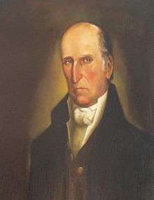
Pickens, formerly called Pickens Courthouse, is a city in Pickens County, South Carolina, United States. The population was 3,126 at the 2010 census. Pickens changed its classification from a town to a city in 1998, but it was not reported to the Census Bureau until 2001.[3] It is the county seat of Pickens County.[4] It was named after Andrew Pickens (1739–1817), an American revolutionary soldier and US Congressman for South Carolina.
Pickens is part of the Greenville–Mauldin–Easley Metropolitan Statistical Area.
History
Present-day Pickens of Pickens County was previously Cherokee Territory. During the American Revolutionary War the Cherokee sided with the Kingdom of Great Britain. When Great Britain was defeated in the war the Cherokee were forced to surrender their land. In 1791 the state legislature established Washington District that comprises present-day Greenville, Anderson, Oconee, and Pickens County. In 1798 Washington District was divided into Greenville and Pendleton districts. The Pendleton district eventually became Anderson, Oconee, and Pickens County. Pendleton District was divided in 1828 into Anderson and Pickens. A courthouse was established on the banks of the Keowee River where the town of Pickens Court House was developed. The Hagood-Mauldin House was built around 1856 and is one of the historic structures of Pickens County. In 1868 the Pickens District was divided for a final time into Pickens and Oconee County. Pickens Court House relocated to its present-day site and was renamed to Pickens. The Pickens Railway was established in 1898 as a Shortline railroad from Easley to Pickens.[5] From 1955 until 1987 Sangamo-Weston Inc. operated a capacitor manufacturing facility just outside Pickens. Until they were banned in the US, Sangamo discharged a significant amount of polychlorinated biphenyls (PCBs) into a tributary of the Twelve Mile River which feeds Lake Hartwell. Sangamo also dumped contaminated waste in six locations in the vicinity of Pickens. In two of these locations the waste was burned forming more dangerous dioxins. According to the Spartanburg Herald-Journal, contamination was discovered at the "Breazeale site", southwest of town. Schlumberger paid $11.8 million to federal and state agencies for injuries to natural resources caused by the contamination.[6]
Geography and climate
Pickens is located at 34°52′54″N 82°42′27″W / 34.88167°N 82.70750°W (34.881700, -82.707477).[7]
According to the United States Census Bureau, the town had a total area of 2.5 square miles (6.4 km²), of which, 2.5 square miles (6.3 km²) of it is land and 0.04 square miles (0.1 km²) of it (0.81%) is water. Pickens also has several small mountains that surround the city. Glassy Mountain,located east of Pickens is a small mountain that can be reached by several small private roads. Glassy Mountain is an excellent example of a piedmont modnadnock, which are rare in South Carolina. Sixty-five acres of the mountain are part of the South Carolina Heritage Trust, and contain varied and rare plant species.<SC DNR Heritage Trust> Perhaps one of the most famous mountains in the area is Table Rock State Park located just to the North of Pickens, but still in the Pickens area,it has been a remarkable symbol to Pickens and can be seen all throughout Pickens and nearby cities such as Easley and Greenville. In addition to Table Rock Mountain, the park contains Pinnacle Mountain, the highest mountain contained entirely within the state of South Carolina.
| Climate data for Pickens, South Carolina, normals 1981–2010, extremes 1951-present | |||||||||||||
|---|---|---|---|---|---|---|---|---|---|---|---|---|---|
| Month | Jan | Feb | Mar | Apr | May | Jun | Jul | Aug | Sep | Oct | Nov | Dec | Year |
| Record high °F (°C) | 79 (26) |
81 (27) |
89 (32) |
93 (34) |
98 (37) |
102 (39) |
106 (41) |
105 (41) |
101 (38) |
97 (36) |
85 (29) |
78 (26) |
106 (41) |
| Average high °F (°C) | 52.1 (11.2) |
55.9 (13.3) |
64.0 (17.8) |
72.7 (22.6) |
79.8 (26.6) |
86.7 (30.4) |
89.7 (32.1) |
88.5 (31.4) |
82.3 (27.9) |
73.1 (22.8) |
63.5 (17.5) |
53.5 (11.9) |
71.82 (22.13) |
| Average low °F (°C) | 28.3 (−2.1) |
31.1 (−0.5) |
37.5 (3.1) |
45.1 (7.3) |
54.8 (12.7) |
63.3 (17.4) |
67.0 (19.4) |
66.3 (19.1) |
59.6 (15.3) |
47.9 (8.8) |
38.2 (3.4) |
30.7 (−0.7) |
47.48 (8.6) |
| Record low °F (°C) | −6 (−21) |
0 (−18) |
8 (−13) |
24 (−4) |
34 (1) |
43 (6) |
51 (11) |
52 (11) |
35 (2) |
26 (−3) |
10 (−12) |
0 (−18) |
−6 (−21) |
| Average precipitation inches (mm) | 4.90 (124.5) |
4.59 (116.6) |
4.80 (121.9) |
3.73 (94.7) |
3.91 (99.3) |
4.43 (112.5) |
4.85 (123.2) |
4.94 (125.5) |
4.28 (108.7) |
3.79 (96.3) |
4.11 (104.4) |
5.11 (129.8) |
53.44 (1,357.4) |
| Average snowfall inches (cm) | 1.2 (3) |
0.8 (2) |
0.4 (1) |
trace | 0 (0) |
0 (0) |
0 (0) |
0 (0) |
0 (0) |
0 (0) |
0.1 (0.3) |
0.4 (1) |
2.6 (6.6) |
| Source: NOAA[8] | |||||||||||||
Demographics
| Historical population | |||
|---|---|---|---|
| Census | Pop. | %± | |
| 1880 | 212 | — | |
| 1890 | 283 | 33.5% | |
| 1900 | 449 | 58.7% | |
| 1910 | 897 | 99.8% | |
| 1920 | 895 | −0.2% | |
| 1930 | 1,130 | 26.3% | |
| 1940 | 1,637 | 44.9% | |
| 1950 | 1,961 | 19.8% | |
| 1960 | 2,198 | 12.1% | |
| 1970 | 2,954 | 34.4% | |
| 1980 | 3,199 | 8.3% | |
| 1990 | 3,042 | −4.9% | |
| 2000 | 3,012 | −1.0% | |
| 2010 | 3,126 | 3.8% | |
| Est. 2015 | 3,173 | [9] | 1.5% |
As of the census[1] of 2000, there were 3,012 people, 1,281 households, and 794 families residing in the town. The population density was 1,227.1 people per square mile (474.7/km²). There were 1,438 housing units at an average density of 585.8 per square mile (226.6/km²). The racial makeup of the town was 80.54% White, 16.80% African American, 0.07% Native American, 0.37% Asian, 1.06% from other races, and 1.16% from two or more races. Hispanic or Latino of any race were 2.49% of the population.
There were 1,281 households out of which 27.9% had children under the age of 18 living with them, 40.8% were married couples living together, 17.7% had a female householder with no husband present, and 38.0% were non-families. 34.4% of all households were made up of individuals and 15.6% had someone living alone who was 65 years of age or older. The average household size was 2.26 and the average family size was 2.88.
.JPG)
In the town the population was spread out with 22.5% under the age of 18, 9.1% from 18 to 24, 26.6% from 25 to 44, 20.8% from 45 to 64, and 21.0% who were 65 years of age or older. The median age was 38 years. For every 100 females there were 82.8 males. For every 100 females age 18 and over, there were 78.0 males.
The median income for a household in the town was $26,364, and the median income for a family was $36,316. Males had a median income of $27,316 versus $19,706 for females. The per capita income for the town was $16,436. About 12.7% of families and 20.0% of the population were below the poverty line, including 26.5% of those under age 18 and 22.5% of those age 65 or over.
Historical attractions
Located three miles north of downtown on US 178 is Hagood Mill, listed on the National Register of Historic Places since 1972. Constructed in 1845 the grist mill was operational until the 1960s. There are monthly southern heritage festivals at the site, and stone ground corn meal and grits may be purchased. <Pickens County SC Cultural Commission>. Of particular interest are petroglyphs discovered in 2003, estimated to be 1,500 to 2,000 years old and possibly from the Hopewell culture. <Anderson SC Independent Mail>. A museum is planned for the historically significant site.
Jocassee Gorges, located about 30 minutes northwest of town, was recently named by National Geographic as one of the 50 Most Beautiful Places in the World.
The Old Pickens Jail is one of the few remaining early jails in Piedmont South Carolina. It was constructed in 1903 and served as a detention facility and offices and living quarters for the county sheriff. The building is on the National Register of Historic Places and now serves the community as a museum.
Schools
The School District of Pickens County is headquartered in Pickens. The city itself contains 5 elementary schools, 1 middle school, and 1 high school.
- Pickens Elementary
- Hagood Elementary
- A.R. Lewis Elementary
- Holly Springs Elementary
- Ambler Elementary
- Pickens Middle
- Pickens High
Notable residents
- Browning Bryant
- Harold Alexander
- Rudy Hayes
- Bobby Baker
- Sam Wyche
References
- 1 2 "American FactFinder". United States Census Bureau. Retrieved 2008-01-31.
- ↑ "US Board on Geographic Names". United States Geological Survey. 2007-10-25. Retrieved 2008-01-31.
- ↑ Population Estimates Boundary Changes, United States Census Bureau, 2007-07-01. Accessed 2008-11-06.
- ↑ "Find a County". National Association of Counties. Retrieved 2011-06-07.
- ↑ "Pickens County: A Brief History". co.pickens.sc.us. County of Pickens.
- ↑ "Company to Pay $11.8 Million in Compensation for PCB-Damaged Fishery and Habitat". Department of Justice. January 30, 2006. Retrieved 9 August 2016.
- ↑ "US Gazetteer files: 2010, 2000, and 1990". United States Census Bureau. 2011-02-12. Retrieved 2011-04-23.
- ↑ "NowData – NOAA Online Weather Data". National Oceanic and Atmospheric Administration. Retrieved 2016-06-12.
- ↑ "Annual Estimates of the Resident Population for Incorporated Places: April 1, 2010 to July 1, 2015". Retrieved July 2, 2016.
- ↑ "Census of Population and Housing". Census.gov. Retrieved June 4, 2015.
United States Environmental Protection Agency NPL Site Narrative for Sangamo Weston Inc/Twelve Mile Creek/Lake Hartwell PCB Contamination
Spartanburg Herald-Journal Aug.24, 1986 page 13 Anderson Independent Mail Pickens County Cultural Commission
External links
Municipalities and communities of Pickens County, South Carolina, United States | ||
|---|---|---|
| Cities | 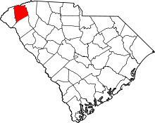 | |
| Towns | ||
| CDP | ||
| Unincorporated communities | ||
| Footnotes | ‡This populated place also has portions in an adjacent county or counties | |