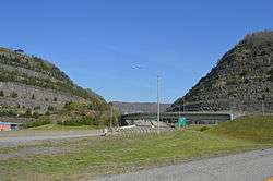
Pikeville Cut-Through

The Pikeville Cut-Through is a rock cut in Pikeville, Kentucky, United States created by the U.S. Army Corps of Engineers, through which passes a four-lane divided highway (Corridor B, numbered as US 23, US 119, US 460, and KY 80), a railroad line (CSX Big Sandy Subdivision), and the Levisa Fork of the Big Sandy River.[1] It is one of the largest civil engineering projects in the western hemisphere, moving nearly 18,000,000 cubic yards (14,000,000 m3)[1] of soil and rock, compared to the Big Dig (15 million cubic yards) and the Panama Canal (240 million cubic yards).[2] Dr. William Hambley, who served as mayor of Pikeville for 29 years, Robert H. Holcomb, Chamber of Commerce president, and Henry Stratton, local attorney, spearheaded the project.
The Pikeville Cut-Through is 1,300 feet (400 m) wide, 3,700 feet (1.1 km) long, and is 523 feet (159 m) deep.[1] The project was completed in 1987 following 14 years of work at a cost of $77.6 million ($162 million in 2016 dollars[3]).[4]
Purpose
The project was initially envisioned by Pikeville native Dr. William Hambley in 1960.[5] He simply wanted to relocate the railbed because he wanted to eliminate the dust that came from the coal hauling trains that passed through the city daily. In 1963, Pikeville received a $38,000 federal grant for a railroad relocation feasibility study and was named a Model City by the recently formed Model Cities Agency, generating even more funding. By 1965, his plan had further developed to accommodate Corridor B of the Appalachian Development Highway System, assuring the construction of the Pikeville Cut-Through.[6]
It was also decided to relocate the Levisa Fork of the Big Sandy River, which then snaked through the downtown area, to eliminate almost yearly flooding. The river bed then was to be reclaimed, significantly increasing the available space for development within the city.[6]
Construction
The project was constructed in four phases by the U.S. Army Corps of Engineers between November 26, 1973 and October 2, 1987.[6]
Phase I of construction began on November 26, 1973. By the end of Phase I, nearly 13,000,000 cubic yards (9,900,000 m3) of rock were blasted from Peach Orchard Mountain to create a channel for the road, railroad, and river. The cost of phase I at completion was $17,250,000.[6]
Phase II of construction began on March 4, 1980. During this phase the coal tipples and railroad tracks were removed from downtown Pikeville, a bridge was constructed across the cut, the river was rerouted, and the former riverbed was filled. 5,000,000 cubic yards (3,800,000 m3) of soil was moved to create 240 acres (0.97 km2) of available land in downtown at a cost of $19,700,000.[6]
Phase III and IV of construction began on March 15, 1983. The final stages consisted of: the construction of the downtown interchanges and flood walls, another new bridge, and the construction of Hambley Boulevard atop the former railbed – a lasting tribute to William Hambley. These two phases created an additional 150 acres (0.61 km2) of downtown property at a cost of $19,700,000.[6]
The project was dedicated on October 2, 1987.[6]
References
- 1 2 3 Maddox, Connie. The Pikeville Cut-Through Project (brochure). Pikeville-Pike County Tourism. Retrieved on 2010-06-17
- ↑ Flow Diversion-Pikeville Cut-Through University of Kentucky. Retrieved on 2010-11-22.
- ↑ Federal Reserve Bank of Minneapolis Community Development Project. "Consumer Price Index (estimate) 1800–". Federal Reserve Bank of Minneapolis. Retrieved October 21, 2016.
- ↑ Thompson, George E. (2009). You Live Where?: Interesting and Unusual Facts about Where We Live. Bloomington, Indiana: iUniverse. ISBN 1-4401-3421-9. Retrieved on 2010-06-17
- ↑ Pikeville "Cut-Thru Project" Kentucky Tourism. Retrieved on 2010-06-17
- 1 2 3 4 5 6 7 The Pikeville Cut-Through Project Pike County, Kentucky Chamber of Commerce. Retrieved on 2010-06-17
External links


Coordinates: 37°28′31″N 82°32′20″W / 37.47527°N 82.53891°W