Pilot Mountain (North Carolina)
| Pilot Mountain | |
|---|---|
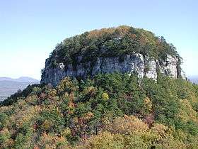 The Big Pinnacle of Pilot Mountain, as viewed from Little Pinnacle Overlook. | |
| Highest point | |
| Elevation | 2,421 ft (738 m) |
| Coordinates | 36°20′24″N 80°28′27″W / 36.3401384°N 80.4742242°WCoordinates: 36°20′24″N 80°28′27″W / 36.3401384°N 80.4742242°W |
| Geography | |
 Pilot Mountain Location in North Carolina | |
| Location | Surry County, North Carolina, U.S. |
| Parent range | Sauratown Mountains |
| Topo map | USGS Pinnacle |
| Climbing | |
| Easiest route | Goldilocks, Grandpa's Belay. Big Pinnacle is closed to climbing. |
| Designated | 1974 |
Pilot Mountain, a metamorphic quartzite monadnock rising to a peak 2,421 feet (738 m) above sea level, is one of the most distinctive natural features in the U.S. state of North Carolina. It is a remnant of the ancient chain of Sauratown Mountains. The Saura Indians, the region's earliest known inhabitants, called the mountain "Jomeokee", meaning "great guide".[1]
U.S. Route 52 passes through the town of Pilot Mountain near the mountain, and the city of Mount Airy is some miles farther north. Pilot Mountain is part of the A.V.A Yadkin Valley, an American Viticultural Area comprising over 50 wineries, including a few wineries in the town of Pilot Mountain.
Pilot Mountain has two distinctive features, named Big and Little Pinnacle. Big Pinnacle (also called "The Knob") has high and colorful bare rock walls, with a rounded top covered by vegetation, reaching approximately 1,400 feet (430 m) above the surrounding terrain. Visitors can take a paved road to the park visitor center and campgrounds, then up to a parking lot on the ridge. Trails from there allow access to the main Little Pinnacle Overlook and other viewing stations.
Pilot Mountain is part of Pilot Mountain State Park, which extends to the Yadkin River via a corridor of land, and it is associated with nearby Horne Creek Living Historical Farm. The curved depression between the ridge slope to the Little Pinnacle and then to the round knob of the Big Pinnacle gives the entire mountain an even more distinctive shape from a distance. Other interesting rock formations are to the east at privately held Sauratown Mountain, and the higher complex at Hanging Rock State Park.
Trails
The Jomeokee Trail leads around the base of Big Pinnacle. The Ledge Spring Trail goes past a large picnic area and down along the ridge crest; its lower loop back up past a small perennial spring follows a long cliff that is a popular location for rock climbing. Big Pinnacle is closed to climbing. Other trails include Sassafras trail, and Grindstone Trail which connects the popular campground to Ledge Spring Trail. Mountain Trail follows up the other side of the ridge to also connect to Ledge Spring Trail. The Grassy Ridge Trail follows along the mountain's base, connecting the lower ends of the Mountain and Grindstone Trails together. The Grassy Ridge Trail also connects to the Corridor Trail, which goes to the park's river section, and it connects to the Mountains-to-Sea and Sauratown Trails, which go to Hanging Rock State Park.[1][2]
Images
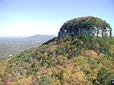 A view in fall of Big Pinnacle from Little Pinnacle Overlook, with Sauratown Mountain and Hanging Rock State Park seen beyond that.
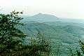 Pilot Mountain's distinctive "saddle" shape as seen from the north. Pilot can also be seen from mile marker 189.1 of the Blue Ridge Parkway in Virginia.
 A view south toward Winston-Salem, NC.
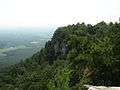 View along the ridge with typical cliffs on the south side.
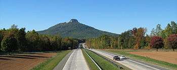 Pilot Mountain from the south on U.S. Route 52
See also
| Wikimedia Commons has media related to Pilot Mountain. |
References
- 1 2 Biggs, Jr., Walter C.; Parnell, James F. (1993) [1989]. "Piedmont". State Parks of North Carolina (2nd ed.). Winston-Salem, North Carolina: John F. Blair. pp. 176–187. ISBN 0-89587-071-1.
Pilot Mountain, like the rocky escarpments in nearby Hanging Rock State Park, is a remnant of the ancient Sauratown Mountain range.
- ↑ Lynch, Ida Phillips; Pendergraft, Bill (2007). "Piedmont". North Carolina State Parks: A Niche Guide. Design by Leesa Brinkley Graphic Design. Chapel Hill, North Carolina: Niche Publishing. pp. 58–59. ISBN 978-0-9794591-0-8.
Like nearby Hanging Rock, this monadnock is a remnant of the ancient Sauratown Mountain range.
External links
- Pilot Mountain State Park
- "Climber's Guide to Pilot Mountain". Carolina Climbers Coalition.
- ClimbPilotNC climbing guide with text and photos