Pindari Glacier

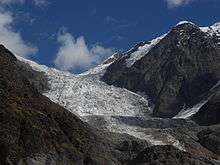
The Pindari Glacier is a glacier found in the upper reaches of the Kumaon Himalayas, to the southeast of Nanda Devi, Nanda Kot. The glacier flows to the south for a short distance of about 3 km (1.9 mi),0.25 km in breadth and gives rise to the Pindari River which meets the Alakananda at Karnaprayag in the Garhwal district.

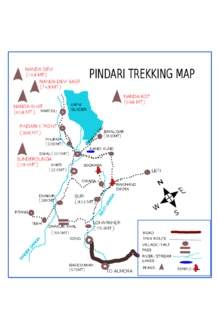
The trail to reach the glacier crosses the villages of Saung, Loharkhet, crosses over the Dhakuri Pass, continues onto Khati village (the last inhabited village on the trail), Dwali, Phurkia and finally Zero Point, Pindar, the end of the trail. Though most of the trail is along the banks of the Pindari River, the river is mostly hidden until after Khati.
The Pindari Glacier trail provides for a 90 km (56 mi) round-trip trek that most people find comfortable to complete in six days. The Pindari Glacier is also famous for other adventure sports like ice climbing and mountain biking.[1]
Survey detail of Glacier
A glacier terminus, toe, or snout, is the end of a glacier at any given point in time. Although glaciers seem motionless to the observer, in reality glaciers are in endless motion and the glacier terminus is always either advancing or retreating. There are several surveys and significant findings on Pindari glacier.In 1906 first survey was done by G.de P.Cotter .Next in 1958 survey was done by Amber P Tiwari and Jangpangi in connection with International Geophysical Year.They had recorded about the retreat of its snout by 1,040 m (3,410 ft) since 1906. There was further retreat of 200 m (660 ft) had been recorded during 1966 expedition. In 1966, as a result of the survey of Pindari glacier,most significant feature had been noticed that was regarding the separation of the Chhanguch branch,until 1958 which was a tributary to the Pindari glacier. After separation, both glaciers have two independent ice caves.Within eight years(1958-1966),several thousand cubic meters of ice have melted away with the retreat of Chhanguch branch.The Best organizer of this trek route is Wetrekkers.They are most friendly and good service provider[2]
See also
References
- ↑ "Mountain Biking the Pindari Glacier | Alienadv.com". www.alienadv.com. Retrieved 2016-04-25.
- ↑
External links
| Wikimedia Commons has media related to Pindari glacier. |
- A trip report on the Pindari Glacier Trek
- Images from Pindari Glacier, Zerop Point and above
- Travel article on Pindari & Kafni Glacier Trek
Coordinates: 30°16′51″N 80°00′47″E / 30.2808°N 80.0130°E