Hemkund
Not to be confused with Homkund
| Hemkund Sahib Punjabi: ਹੇਮਕੁੰਟ ਸਾਹਿਬ Hindi: हेमकुंड साहिब Shri Hemkund Saheb | |
|---|---|
| pilgrimage site; Gurudwara | |
|
Gurudwara Hemkund Sahib | |
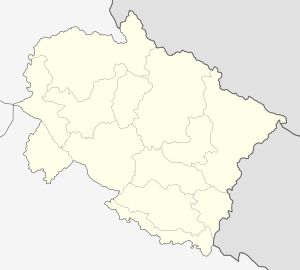 Hemkund Sahib  Hemkund Sahib Location in Uttarakhand, India | |
| Coordinates: 30°42′0.78″N 79°36′57.54″E / 30.7002167°N 79.6159833°ECoordinates: 30°42′0.78″N 79°36′57.54″E / 30.7002167°N 79.6159833°E | |
| Country |
|
| State | Uttarakhand |
| District | Chamoli district |
| Elevation | 4,632.96 m (15,200.00 ft) |
| Languages | |
| • Official | Hindi |
| Time zone | IST (UTC+5:30) |
| PIN | 249401 |
| Vehicle registration | UK |
| Website |
www |
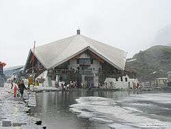
'Hemkund Sahib, known as Gurudwara Sri Hemkund Sahib Ji, is a Sikh place of worship and pilgrimage site in Chamoli district, Uttarakhand, India. It is devoted to Guru Gobind Singh Ji (1666–1708), the tenth Sikh Guru, and finds mention in Dasam Granth, a work dictated by Guruji himself. With its setting of a glacial lake surrounded by seven mountain peaks, each adorned by a Nishan Sahib on its cliff, it is according to the Survey of India located in the Himalayas at an elevation of 4,632 meters (15,197 feet).[1] It is approached from Gobindghat on the Rishikesh-Badrinath highway. The main town near Gobindghat is Joshimath.
Etymology
Hemkunt is a Sanskrit name derived from Hem ("Snow") and Kund ("bowl"). Dasam Granth says this is the place where Pandu Raja practiced Yoga. In addition, the Dasam Granth says God ordered Sikh Guru Gobind Singh to take birth while he was in deep meditation at the mount of Hemkunt. [2]

Travel

Hemkund is inaccessible from October through April because of snow bound paths and glaciers. Sikh pilgrims arrive in May and set to work to repair the damage to the path over the winter, which tradition is called kar seva ("work service"), a concept which forms an important tenet of the Sikh faith.
The take-off point for Hemkund Sahib is the town of Govindghat about 275 kilometres (171 mi) from Rishikesh. The 13 kilometres (8.1 mi) trek is along a reasonably well maintained path to the village of Ghangaria (also called Govinddham). This path can be covered either by walk or by pony and a Gurudwara here gives shelter to pilgrims. In addition there are a few hotels and a camp ground with tents and mattresses. A 1,100-metre (3,600 ft)climb on a 6-kilometre (3.7 mi) of stone paved path leads Hemkund. Overnight stay is not allowed at Hemkund Sahib and so it is necessary to leave by 2 PM to make it back to Govindghat by nightfall.
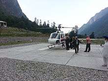
From Delhi, tourists take the train to Haridwar and then travel by bus to Govindghat via Rishikesh. It is also possible to drive from Delhi to Govindghat, a distance of about 500 kilometres (310 mi) which takes around 18 hours to cover. Recently, an Indian airline company has started a helicopter service between Govindghat and Ghangria. The flight takes about 5 minutes.
A recent study examining altitude sickness at Hemkund Sahib found that almost one-third of pilgrims who traveled to Hemkund suffered from Acute Mountain Sickness (a form of altitude sickness). As approximately 150,000 pilgrims are believed to travel to Hemkund Sahib each trekking season, almost 50,000 people are at risk of developing Acute Mountain Sickness each year. The authors stated the difficult nature of the trek, limited water consumption and lack of awareness regarding altitude sickness as the main contributory factors.[3]
Present Gurudwara
Design and construction of the present gurudwara was started in the mid-1960s, after Major General Harkirat Singh, Engineer-in-Chief, Indian Army visited the gurudwara. Major General Harkirat Singh selected Architect Siali to head the design and construction effort. Thereafter, Architect Siali luddu made annual trips to Hemkunt Sahib and organized and supervised complex construction.
Valley of Flowers
About 3 km from Gobinddham is the 5 km long Valley of Flowers. The Indian Government has declared this valley a national park. It is situated in Nanda Devi Bio Reserve, and all activities are carefully regulated to preserve the valley in pristine condition. The best months to visit are July and August, during the monsoons. Legend has it that a flower called Brahma-Kamal blossoms here every 12 years. The trek to the valley is relatively easy and is a popular second destination for pilgrims visiting Hemkunt Sahib.
Gallery
- Views of Hemkund (Hemkunt) Sahib
-

Gurudwara in front of lake
-

Gurdwara Hemkunt Sahib
-
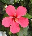
Hibiscus flower
-

Brahmkamal
References
- ↑ Hemkunt Sahib at Google maps Satellite view: lake, Gurudwara building on west shore, zigzag pilgrim path from Ghanghariya (2 km west) to west shore. Terrain view: Hemkund Sahib at 4,200 m, Ghanghariua at 3,100 m.
- ↑ Robin Rinehart (2014): The Dasam Granth. In Oxford Handbook of Sikh Studies. Oxford: The Oxford University Press, p.138
- ↑ Sahota IS, Panwar NS. A pilot study on the prevalence of Acute Mountain Sickness at Hemkund Sahib in the Indian Himalayas. Indian Journal of Occupational and Environmental Medicine. 2013; 17 (1): 12-15
- Gurdwara in the Himalayas: Sri Hemkunt Sahib, by Suparna Rajguru, M. S. Siali. Published by Hemkunt, 2001. ISBN 81-7010-292-8.
- Pilgrimage to Hemkunt, by Jaswant Singh Neki. Photographs by Sondeep Shankar. New Delhi, UBSPD, 2002, ISBN 81-7476-375-9.
- The Illustrated History of the Sikhs, by Khushwant Singh. Oxford University Press, 2006. ISBN 0-19-567747-1. Page 48.
External links
| Wikimedia Commons has media related to Hemkund. |
- Hemkund Sahib Yatra Information
- HemKund Sahib Road Map
-
 Hemkund travel guide from Wikivoyage
 - Distance Between Haridwar to HemKund Sahib