Satopanth Tal
| Satopanth Trail | |
|---|---|
|
Satopanth Tal | |
| Location | Uttarakhand, India |
| Trailheads | Badrinath to Satopanth Tal |
| Use | Hiking |
| Elevation | |
| Highest point | Satopanth Top |
| Lowest point | Badrinath |
| Hiking details | |
| Trail difficulty | Three star trek |
| Season | July to September |
| Sights | Mt. Nilkantha, Mt. Balakun, Satopanth Glacier, Bhagirath Kharak Glacier, Alakapuri |
Satopanth Tal is a lake in Uttarakhand, India, located in the midst of snow-capped peaks at an altitude of 4,600 metres (15,100 ft) above sea-level. The lake is considered to be of religious significance to the local people; residents of Mana village throw the ashes of the dead in the lake. There is a saint known as Moni Baba, for he had stopped talking from a very early time. There is a common belief that he can live on only sun and air, if food is unavailable.
Popular beliefs
Many people believe that the Trimoortis, viz, Brahma, Vishnu and Mahesh, bathe in the lake in an auspicious day. Also some types of birds are found here, which pick up the pollutants of the lake and thus keep the lake clean. These birds are not found anywhere. The local belief is that they are the Gandharvas disguised, who guard the lake against evils.
Geography
Located in the midst of snow-capped peaks at an altitude of 16,000 feet from sea level, Satopanth Tal is 22 km ahead of Badrinath. Balakun Peak, Kuber Top, Mt. Nilkantha, and Mt. Swargarohini are the peaks visible en route. The lake remains under snow from the end of September to the middle of May or sometimes end of June. The normal summer temperature remains around 12 °C in day and 7 °C to −5 °C in night, while the winter temperature may drop to even −25 °C in day and −36 °C in night.[1]
| Nearest village: Mana (about 18 km) |
| Nearest rail head: Rishikesh |
| Nearest airport: Jolly Grant Airport |
Trek route
The trek to Satopanth starts from Mana, 3 km ahead of Badrinath. Crossing the river, we have to trek the regular trekking route to Vasudhara, the trail ascends higher and one sees Vasudhara Falls at a distance on the other bank of Alakananda River. Then crossing a dangerous glacier, the local name of which is Dhano Glacier, one reaches Laxmivan, 5 km ahead of Vasudhara. The night stay is done at caves or tents, which is very essential on the route. Laxmiban is 13 km from Badrinath. The next day, if one starts early they can reach Chakratirth 5 km ahead, by crossing the Dhano Glacier, at mid-day. After taking a nap, one should immediately start for Sahasradara, 3 km ahead. The Satopanth Top from where Kuber Glacier, and Kuber Top is visible, is only 3 km from Sahasradhara. The back face of Mt. Nilkantha is visible from here. From here Satopanth Tal is only a 2 km trek.[2] Steeped in ancient mythology, The Satopanth Tal is located in Uttarakhand, amidst snow-capped peaks at an altitude of 15, 100 feet, above sea level. It lies at a distance of about 25 km from the holy city of Badrinath, and can be reached after an arduous trek, crossing Laxmiban and Chakratirth, covering the enthralling journey by walking on boulders, moraines, glaciers and knife edge ridges. Hiden among the most impressive peaks of the garhwal region, this triangular lake is steeped in mythology. The "satyapanth" or the "path of truth" is believed to be the path taken by the Pandavas, on their journey to the heaven. Traces of the myth lingers all over the path,where local names still bears resemblance to the story. Finally the Satopanth Tal is believed to be the place where the celestial vehicle received "yudhisthira". The local legend also goes that, The three gods, namely, The brahma, Vishnu and Mahesh, visits the lake for a holy dip on ekadashi and each of them, occupy, one corner of the lake. The lofty Chowkhamba (23,413 feet), looms over the perfectly triangular green waters of the ethereal lake, along with, The Neelkanth (21,638 feet), The Balakun (20,040 feet), Parvati and others. The trekk starts at Mana, the last Indian village and the trail takes us through the lush greenery of the Vasundhara valley. The first campsite of Chamotli Bugiyal, is decorated with myriads of tiny wildflowers which bloom during the summer and monsoons.The formidable birch forests of Laxmiban, the place where Draupadi supposedly breathed her last, and the vast greenery transforms into the formidable ridge walks as one reaches the glacial moraines of the Dhano Glacier. The land is a beautiful symphony of green patches and glacial ice. The campsite at Chakratirtha, the place where The great warrior Arjuna collapsed, is enriched with the magnificent view of the upper Satopanth Glacier, with the Swargarohini and Choukambha peaks, towering in the back. The final short yet tricky trail to Saptopanth Tal, meanders through a maze of boulders and moraine. The valley is engulfed with the sound of breaking glaciers. But all the tireness of the strenuous trek is easily forgotten when the austere and peaceful green waters of the holy lake suddenly comes into view. The view from the tal is trainquil. With the mighty peaks looming all around the effect is surreal. The color changes in the snow, as the morning sun hits the Chowkhamba, is a sight one carries throughout his life.[3]
Essentials for Satopanth Tal trek
Firstly inner-line permit has to be taken from Joshimath. A guide, and experienced porters must be taken. There are no night stay places, so a tent, stove, food and mattress are needed. The trek route is a bit tough and only experienced trekkers should undertake it. En route the Dhano Glacier has to be crossed and en route Chakratirth one sharp ridge has to be crossed.
Gallery
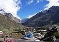 Towards Mana
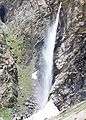 Vasudhara Falls en route Laxmivan
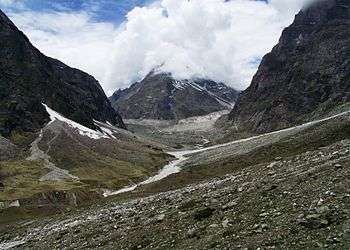 View of Balakun from Vasudhara Falls
 Dhano Glacier en route
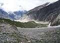 Crossing a ridge en route Chakratirth
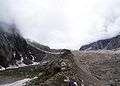 The ridge en route
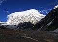 Near Satopanth Tal
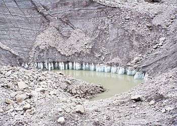
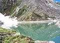 Satopanth Tal
References
External links
- http://www.uttaranchal.org.uk/uforums/viewtopic.php?f=15&t=268
- http://trekwords.wordpress.com/2008/11/05/on-the-bank-of-satopanth/