Pitt Town, New South Wales
| Pitt Town New South Wales | |||||||||||||
|---|---|---|---|---|---|---|---|---|---|---|---|---|---|
 | |||||||||||||
| Coordinates | 33°35′14″S 150°51′19″E / 33.5872°S 150.8552°ECoordinates: 33°35′14″S 150°51′19″E / 33.5872°S 150.8552°E | ||||||||||||
| Population | 1,963 (2011 census)[1] | ||||||||||||
| Postcode(s) | 2756 | ||||||||||||
| Location | 59 km (37 mi) from Sydney CBD | ||||||||||||
| LGA(s) | City of Hawkesbury | ||||||||||||
| State electorate(s) | Hawkesbury | ||||||||||||
| Federal Division(s) | Macquarie | ||||||||||||
| |||||||||||||
Pitt Town is a historic town and suburb of Sydney, in the state of New South Wales, Australia. Pitt Town is 59 kilometres north-west of the Sydney central business district in the local government area of the City of Hawkesbury. It is bounded in the north by the Hawkesbury River.
History
Pitt Town is one of the five 'Macquarie Towns' established by Governor Macquarie in 1810. It is named after William Pitt the Younger, the 18th Century British Prime Minister. A site for a village was laid out in 1811 but developed very slowly and was relocated to its present location by 1815. By 1841 there were only 36 houses in the town due to its location being too far from the rich river flats and the consequent long daily trek for farmers to their holdings.
The street names of Pitt Town bear testament to the 1808 British Cabinet, including Eldon, Grenville, Bathurst, Liverpool, Buckingham, Chattham and Chandos Streets. (Chandos Street being later renamed 'Church Street'[2]
Electricity first came to Pitt Town in 1935.
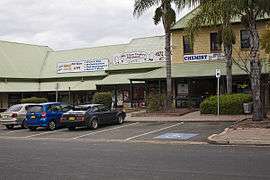
In 1987, the Pitt Town Shopping Centre was constructed with the Bird in Hand Inn being converted to a public inn. For most of the 20th Century, it served as a general store.
1915 marked the 100th anniversary of the re-establishment of Pitt Town and 2015 marks the bicentenary.
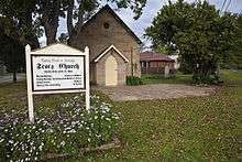
Pitt Town has one public school in Buckingham Street, two churches (St James Anglican Church on Bathurst Street and The Scotts Church opposite in Bathurst Street and two cemeteries. The Pitt Town General Cemetery is located off Old Stock Route Road and the Pitt Town (St James) Anglican Cemetery off Old Pitt Town Road, which contains many of the early pioneers of Pitt Town.
During World War II, to cope with the additional volume of aircraft movements at the Richmond Royal Australian Air Force base (RAAF), a second airstrip was built in Pitt Town in what is known today as Airstrip Road. Following the end of the war, the airstrip was abandoned and became an automotive race and testing track for Ferodo Australia.
In 1981, Pitt Town becoming known nationally and internationally as the setting for 'Wandin Valley' in the long-running television series A Country Practice' (1981-1993). The series was broadcast twice weekly on the Australian Television Network Seven Network (ATVN 7).
Historic buildings and sites
Pitt Town has many heritage buildings in excellent condition with many recognised as local and stage listed heritage items.
- The former Maid of Australia Inn, a typical street corner inn located at 87 Bathurst Street, which operated between the 1850s and 1890s. At 104 Bathurst Street are the remnants of the 'Blighton Arms'. The original owner, Henry Fleming, lost his license in 1819 but re-opened in 1830, renaming it the 'Macquarie Arms'. Next door is 'Mulgrave Place, a house built in 1823; the verandah in about 1860, and the north wing in 1913.
- St James's Anglican Church on Bathurst Street was designed by Edmund Blacket. It was built by Thomas Collison for £1050 in 1857-58. Blacket also designed the 24 pews, pulpit, reading desk and communion rail. The church is in the Victorian Gothic Revival style, which was normal practice for religious buildings, and is listed on the Register of the National Estate.[3]
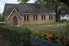
- Scots Presbyterian Church, a much simpler building than St James, was built and dedicated in 1862. Located opposite the Anglican church in Bathurst Street. It is in the Gothic Revival style and is listed on the Register of the National Estate.[4]
- At 120 and 126 Bathurst Street there are late nineteenth century weatherboard houses; at 132 Bathurst Street there are very old slab cottages and outbuildings.
- Bona Vista in Johnston Street was built in 1888. It has a long entrance drive with Norfolk Island pines and camphor. Its original rural landscaped setting has now been lost through the recent residential subdivision of the area.
- At the northern end of Bathurst Street, overlooking Pitt Town Bottoms, is The Manse, which in fact belonged to the oldest Presbyterian Church in Australia, situated down the river at Ebenezer. This illustrates that the early communities were not divided by the Hawkesbury River but united by it. The Manse is listed on the Register of the National Estate.[4]
Population
Its population was 1,963 (including Pitt Town Bottoms) at the 2011 census.[1] Pitt Town's population is growing due to the Vermont Development that began in 2007.
Pop culture
The television drama series A Country Practice used this village for many external scenes. The heritage house opposite Pitt Town Public School was used as the home of characters Frank and Shirley Gilroy (Brian Wenzel and Lorrae Desmond). The Hardware Store on the corner of Bathurst, Eldon and Grenville Streets was known as 'Muldoon's Store', the Bird in Hand Inn was known as the 'Wandin Valley General Store'. Other buildings used include a number of private residential dwellings along Bathust Street for Matron Maggie Sloan (Joan Sydney) and Esme Watson (Joyce Jacobs). The television series used a good number of other well known buildings in the Hawkesbury area. Including the hospital (located in Oakville), the doctor's surgery (located in Windsor) Burrigan High School (Windsor High School), Burrigan Swimming Pool (the former Hornsby Aquatic Centre - demolished 2012). When ACP was relaunched on rival Network Ten, however in 1994, filming at moved to Emerald, Victoria
See also
References
- 1 2 Australian Bureau of Statistics (31 October 2012). "Pitt Town (State Suburb)". 2011 Census QuickStats. Retrieved 27 April 2015.
- ↑ Edwards.M, 2012.'NAMES BEHIND THE NAMES:THE ORIGINS AND MEANINGS OF STREET NAMES IN PITT TOWN: PART 1 A STUDY OF COLONIAL NOMENCLATURE'
- ↑ The Heritage of Australia, Macmillan Company, 1981, p.2/122
- 1 2 The Heritage of Australia, p.2/122