Vayas
| Barrio Vayas | |
|---|---|
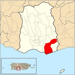 Location of barrio Vayas within the municipality of Ponce shown in red | |
| Country |
|
| Territory |
|
| Municipality |
|
| Area | |
| • Total | 10.47 sq mi (27.1 km2) |
| • Land | 7.12 sq mi (18.4 km2) |
| • Water | 3.35 sq mi (8.7 km2) |
| Population (2000) | |
| • Total | 1,338 |
| • Density | 188/sq mi (73/km2) |
| Source: 2000 Census | |
Vayas is one of the 31 barrios of the municipality of Ponce, Puerto Rico. Along with Playa, Bucana, Canas and Capitanejo, Vayas is also one of Ponce's five coastal barrios. Together with Capitanejo, Vayas is also one of two rural coastal barrios in the municipality.[1] It was organized in 1831, at which time it was divided into Vayas Norte and Vayas Sur; in 1878 the two were subsequently merged into today's Vayas.[2]
Location
Vayas is a rural, coastal barrio located in the southern region of the municipality, east of the city of Ponce, and southeast of the traditional center of the city, Plaza Las Delicias. It is located at 18.0107°N 66.5567°W, with an elevation of 43 feet.[3] The toponomy, or origin of the name, is related to the edges or boundary of an area or barrio.[4]
Boundaries
It is bounded on the North by PR-1 and La Esperanza Street, on the South by the Caribbean Sea, on the West by Bucara Street/Los Caobos Avenue, PR-52 (roughly), and the Costa Caribe Country Club East Access Road, and on the East by Río Inabón.[5][6][7][8]
In terms of barrio-to-barrio boundaries, Vayas is bounded in the North by Sabanetas and Coto Laurel, in the South by the Caribbean Sea, in the West by Bucaná, and in the East by Capitanejo.Autonomous Municipality of Ponce. Office of Territorial Planning. (Municipio Autonomo de Ponce. Oficina de Ordenacion Territorial.)[9]
Features and demographics
Unlike most other barrios of Ponce, Vayas' landscape is entirely flat. Vayas has the third longest coastline of all five of Ponce's coastal barrios, after Canas and Playa. Vayas has 7.1 square miles (18 km2) of land area and 3.4 square miles (8.8 km2) of water area.[10][11]
In 2000, the population of Vayas was 1,338 persons, and it had a density of 188 persons per square mile.[7][12]
The main roads serving barrio Vayas are PR-52 and PR-1.
Notable landmarks
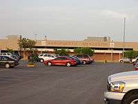
Barrio Vayas is home to Ponce's Mercedita Airport and Destileria Serralles.[13]
Notable people from Vayas
- Carmín Vega, comedian from the Mercedita sector of Barrio Vayas.
Coordinates: 17°58′54″N 66°34′15″W / 17.9817311°N 66.5707290°W[14]
References
- ↑ Sunny A. Cabrera Salcedo. Hacia un Estudio Integral de la Toponimia del Municipio de Ponce, Puerto Rico. Ph. D. dissertation. May 1999. University of Massachusetts Amherst. Graduate School. Department of Spanish and Portuguese. Page 22.
- ↑ Barrios de Ponce. Antepasados Esclavos.(From: Pedro Tomás de Córdoba. Memorias geográficas, históricas, económicas y estadísticas de la Isla de Puerto Rico.) Retrieved 28 November 2014.
- ↑ U.S. Geological Survey. Topographic Map of Ponce. Map Styles: Map and Shaded. Trails.com. From: USGS. Topo Map. Projection: NAD83/WGS84. Coordinates and Elevation of Barrio Vayas. Retrieved February 25, 2010.
- ↑ Government of the Municipality of Ponce. Periodico "El Señorial". Special issue: Carnaval Ponceño 2013. February 2013. Page 17. Ponce, Puerto Rico.
- ↑ Webcensus. Government of the Commonwealth of Puerto Rico. General Purpose Population Data, Census 2000. Unidad de Sistemas de Información Geográfica, Área de Tecnología de Información Gubernamental, Oficina de Gerencia y Presupuesto. Gobierno de Puerto Rico. Retrieved February 24, 2010.
- ↑ Maptest. Government of the Commonwealth of Puerto Rico. General Purpose Population Data, Census 2000. Unidad de Sistemas de Información Geográfica, Área de Tecnología de Información Gubernamental, Oficina de Gerencia y Presupuesto. Gobierno de Puerto Rico. Retrieved February 24, 2010.
- 1 2 U.S. Geological Survey. Topographic Map of Ponce. Map Styles: Map and Shaded. Trails.com. From: USGS. Topo Map. Projection: NAD83/WGS84. Retrieved February 25, 2010.
- ↑ GeoLocalizador - Junta de Planificacion. Junta de Planificacion. Gobierno de Puerto Rico. Retrieved 8 September 2012.
- ↑ Arecibo Web. Ponce, Puerto Rico: Barrios. Retrieved February 25, 2010.
- ↑ U.S. Census Bureau. Census 2000. Ponce and Its Barrios. (Ponce Municipio, Puerto Rico -- County Subdivision and Place. GCT-PH1. Population, Housing Units, Area, and Density: 2000. Data Set: Census 2000 Summary File 1 (SF 1) 100-Percent Data) Retrieved February 25, 2010.
- ↑ City Melt Retrieved, February 25, 2010.
- ↑ Autonomous Municipality of Ponce. Office of Territorial Planning. (Municipio Autonomo de Ponce. Oficina de Ordenacion Territorial.) Mapa de Localizacion Limite de Barrios de Ponce. Retrieved February 20, 2010.
- ↑ Mercedita Airport is located in Barrio Vayas Retrieved December 3, 2009.
- ↑ U.S. Geological Survey Geographic Names Information System: Vayas Barrio
External links
- Management Plan for La Esperanza Nature Preserve in Ponce, Puerto Rico. Matthew Bourque, Drew Digeser, Stephen Partridge, Hussein Yatim. Worcester Polytechnic Institute. Worcester, Massachusttes. 2 May 2012. Retrieved 4 August 2013.