Vertical deflection
The vertical deflection (deflection of the plumb line, astro-geodetic deflection) at a point on the Earth is a measure of how far the direction of the local gravity field has been shifted by local anomalies such as nearby mountains. (Here "gravity" means apparent gravity—true gravity "reduced" by the earth's spin). They are widely used in geodesy, for surveying networks and for geophysical purposes.
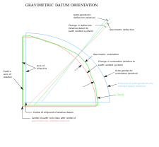
The vertical deflection (abbrev. VD or ξ,η) is the angle between the true zenith (plumb line) and the line perpendicular to the surface of the reference ellipsoid chosen to approximate the earth's sea-level surface. VDs are caused by mountains and by underground geological irregularities and can amount to angles of 10″ (flat areas) or 20–50″ (alpine terrain).
The deflection of the vertical has a north-south component ξ and an east-west component η. The value of ξ is the astronomic latitude minus the geodetic latitude (taking north latitudes to be positive and south latitudes to be negative); the latter is usually calculated by geodetic network coordinates. The value of η is the astronomic longitude minus the geodetic longitude (taking east longitudes to be position and west longitudes to be negative). When a new mapping datum replaces the old, with new geodetic latitudes and longitudes on a new ellipsoid, the calculated vertical deflections will change too.
The NGS website gives vertical deflection anywhere in the United States here and here.
Determination of vertical deflections
The deflections reflect the undulation of the geoid and gravity anomalies, for they depend on the gravity field and its inhomogeneities.
VDs are usually determined astronomically. The true zenith is observed astronomically with respect to the stars, and the ellipsoidal zenith (theoretical vertical) by geodetic network computation, which always takes place on a reference ellipsoid. Additionally, the very local variations of the VD can be computed from gravimetric survey data and by means of digital terrain models (DTM), using a theory originally developed by Vening-Meinesz.
VDs are used in astro-geodetic levelling, a geoid determination technique. As a vertical deflection describes the difference between the geoidal and ellipsoidal normals, it represents the horizontal gradient of the undulations of the geoid (i.e., the separation between geoid and reference ellipsoid). Given a starting value for the geoid undulation at one point, determining geoid undulations for an area becomes a matter for simple integration.
In practice, the deflections are observed at special points with spacings of 20 or 50 kilometers. The densification is done by a combination of DTM models and areal gravimetry. Precise VD observations have accuracies of ±0.2″ (on high mountains ±0.5″), calculated values of about 1–2″.
The maximal VD of Central Europe seems to be a point near the Großglockner (3,798 m), the highest peak of the Austrian Alps. The approx. values are ξ = +50″ and η = −30″. In the Himalaya region, very asymmetric peaks may have VDs up to 100″ (0.03°). In the rather flat area between Vienna and Hungary the values are less than 15", but scatter by ±10″ for irregular rock densities in the subsurface.
More recently, a combination of digital camera and tiltmeter have also been used, see zenith camera.[1]
Application of deflection data
Vertical deflections are principally used in four matters:
- For precise calculation of survey networks. The geodetic theodolites and levelling instruments are oriented with respect to the true vertical, but its deflection exceeds the geodetic measuring accuracy by a factor of 5 to 50. Therefore, the data have to be corrected exactly with respect to the global ellipsoid. Without these reductions, the surveys may be distorted by some centimeters or even decimeters per km.
- For the geoid determination (mean sea level) and for exact transformation of elevations. The global geoidal undulations amount to 50–100 m, and their regional values to 10–50 m. They are adequate to the integrals of VD components ξ,η and therefore can be calculated with cm accuracy over distances of many kilometers.
- For GPS surveys. The satellites measurements refer to a pure geometrical system (usually the WGS84 ellipsoid), whereas the terrestrial heights refer to the geoid. We need accurate geoid data to combine the different types of measurements.
- For geophysics. Because VD deflection data are affected by the physical structure of the Earth's crust and mantle, geodesists are engaged in models to improve our knowledge of the Earth's interior. Additionally and similar to applied geophysics, the VD data can support the future exploration of raw materials, oil, gas or ores.
See also
References
- ↑ Hirt, C.; Bürki, B.; Somieski, A.; Seeber, G. N. (2010). "Modern Determination of Vertical Deflections Using Digital Zenith Cameras". Journal of Surveying Engineering. 136: 1. doi:10.1061/(ASCE)SU.1943-5428.0000009.