Plummer, Idaho
| Plummer, Idaho | |
|---|---|
| City | |
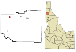 Location in Benewah County and the state of Idaho | |
| Coordinates: 47°20′0″N 116°53′4″W / 47.33333°N 116.88444°WCoordinates: 47°20′0″N 116°53′4″W / 47.33333°N 116.88444°W | |
| Country | United States |
| State | Idaho |
| County | Benewah |
| Government | |
| • Mayor | Tim Clark |
| Area[1] | |
| • Total | 1.25 sq mi (3.24 km2) |
| • Land | 1.25 sq mi (3.24 km2) |
| • Water | 0 sq mi (0 km2) |
| Elevation | 2,743 ft (836 m) |
| Population (2010)[2] | |
| • Total | 1,044 |
| • Estimate (2012[3]) | 1,028 |
| • Density | 835.2/sq mi (322.5/km2) |
| Time zone | Pacific (PST) (UTC-8) |
| • Summer (DST) | PDT (UTC-7) |
| ZIP code | 83851 |
| Area code(s) | 208 |
| FIPS code | 16-63910 |
| GNIS feature ID | 0374457 |
| Website | plummerid.govoffice3.com |
| Historical population | |||
|---|---|---|---|
| Census | Pop. | %± | |
| 1920 | 450 | — | |
| 1930 | 346 | −23.1% | |
| 1940 | 399 | 15.3% | |
| 1950 | 395 | −1.0% | |
| 1960 | 344 | −12.9% | |
| 1970 | 443 | 28.8% | |
| 1980 | 634 | 43.1% | |
| 1990 | 804 | 26.8% | |
| 2000 | 990 | 23.1% | |
| 2010 | 1,044 | 5.5% | |
| Est. 2015 | 1,019 | [4] | −2.4% |
Plummer is a city in Benewah County, Idaho, United States. The population was 1,044 at the 2010 census, up from 990 in 2000.[6] It is the largest city within the Coeur d'Alene Reservation, and is accessed by U.S. Route 95, the state's primary north-south highway.
Geography
Plummer is located at 47°20′0″N 116°53′4″W / 47.33333°N 116.88444°W (47.333423, -116.884393),[7] at an elevation of 2,743 feet (836 m) above sea level.
According to the United States Census Bureau, the city has a total area of 1.25 square miles (3.24 km2), all of it land.[1]
Climate
Plummer has a warm-summer Mediterranean climate (Csb) according to the Köppen climate classification system, although its winter months nearly qualify it as having a dry-summer humid continental climate (Dsb).
| Climate data for Plummer (1950-2012) | |||||||||||||
|---|---|---|---|---|---|---|---|---|---|---|---|---|---|
| Month | Jan | Feb | Mar | Apr | May | Jun | Jul | Aug | Sep | Oct | Nov | Dec | Year |
| Record high °F (°C) | 56 (13) |
62 (17) |
70 (21) |
78 (26) |
92 (33) |
95 (35) |
101 (38) |
100 (38) |
97 (36) |
86 (30) |
65 (18) |
57 (14) |
101 (38) |
| Average high °F (°C) | 35.9 (2.2) |
41.1 (5.1) |
47.4 (8.6) |
55.4 (13) |
64 (18) |
70 (21) |
81.5 (27.5) |
81.5 (27.5) |
73.4 (23) |
56.7 (13.7) |
43 (6) |
34.1 (1.2) |
57 (14) |
| Average low °F (°C) | 24.4 (−4.2) |
26.6 (−3) |
30.1 (−1.1) |
34.2 (1.2) |
38.5 (3.6) |
44.4 (6.9) |
50.6 (10.3) |
50 (10) |
43.3 (6.3) |
34.4 (1.3) |
30.6 (−0.8) |
24.5 (−4.2) |
36 (2) |
| Record low °F (°C) | −15 (−26) |
−15 (−26) |
0 (−18) |
17 (−8) |
25 (−4) |
28 (−2) |
36 (2) |
31 (−1) |
27 (−3) |
9 (−13) |
−6 (−21) |
−8 (−22) |
−15 (−26) |
| Average precipitation inches (mm) | 3.17 (80.5) |
2.95 (74.9) |
2.27 (57.7) |
1.93 (49) |
2.5 (64) |
1.62 (41.1) |
0.61 (15.5) |
0.71 (18) |
0.74 (18.8) |
2.17 (55.1) |
3.92 (99.6) |
4.11 (104.4) |
26.7 (678) |
| Average snowfall inches (cm) | 5.5 (14) |
1.8 (4.6) |
1.1 (2.8) |
0 (0) |
0.2 (0.5) |
0 (0) |
0 (0) |
0 (0) |
0 (0) |
0 (0) |
0.9 (2.3) |
5 (13) |
14.4 (36.6) |
| Average precipitation days | 13 | 12 | 10 | 10 | 9 | 8 | 3 | 3 | 3 | 8 | 16 | 14 | 109 |
| Source: [8] | |||||||||||||
Demographics
2010 census
As of the census[2] of 2010, there were 1,044 people, 374 households, and 261 families residing in the city. The population density was 835.2 inhabitants per square mile (322.5/km2). There were 405 housing units at an average density of 324.0 per square mile (125.1/km2). The racial makeup of the city was 45.7% White, 1.1% African American, 42.7% Native American, 0.1% Pacific Islander, 0.7% from other races, and 9.8% from two or more races. Hispanic or Latino of any race were 8.0% of the population.
There were 374 households of which 43.3% had children under the age of 18 living with them, 41.7% were married couples living together, 15.2% had a female householder with no husband present, 12.8% had a male householder with no wife present, and 30.2% were non-families. 25.4% of all households were made up of individuals and 10.9% had someone living alone who was 65 years of age or older. The average household size was 2.78 and the average family size was 3.27.
The median age in the city was 31.4 years. 32.8% of residents were under the age of 18; 9.6% were between the ages of 18 and 24; 22.3% were from 25 to 44; 24.8% were from 45 to 64; and 10.3% were 65 years of age or older. The gender makeup of the city was 51.1% male and 48.9% female.
2000 census
As of the census[9] of 2000, there were 990 people, 336 households, and 257 families residing in the city. The population density was 875.2 people per square mile (338.3/km²). There were 380 housing units at an average density of 335.9 per square mile (129.8/km²). The racial makeup of the city was 55.86% White, 0.71% African American, 39.29% Native American, 0.10% Asian, 0.10% Pacific Islander, 0.81% from other races, and 3.13% from two or more races. Hispanic or Latino of any race were 2.93% of the population.
There were 336 households out of which 38.4% had children under the age of 18 living with them, 49.4% were married couples living together, 17.3% had a female householder with no husband present, and 23.5% were non-families. 19.6% of all households were made up of individuals and 8.0% had someone living alone who was 65 years of age or older. The average household size was 2.95 and the average family size was 3.33.
In the city the population was spread out with 33.3% under the age of 18, 12.2% from 18 to 24, 26.6% from 25 to 44, 17.6% from 45 to 64, and 10.3% who were 65 years of age or older. The median age was 29 years. For every 100 females there were 96.8 males. For every 100 females age 18 and over, there were 88.6 males.
The median income for a household in the city was $28,438, and the median income for a family was $31,806. Males had a median income of $26,583 versus $20,357 for females. The per capita income for the city was $10,564. About 17.3% of families and 22.0% of the population were below the poverty line, including 23.8% of those under age 18 and 18.8% of those age 65 or over.
History
The city's first church was built in 1912.[10]
References
- 1 2 "US Gazetteer files 2010". United States Census Bureau. Retrieved 2012-12-18.
- 1 2 "American FactFinder". United States Census Bureau. Retrieved 2012-12-18.
- ↑ "Population Estimates". United States Census Bureau. Retrieved 2013-06-03.
- ↑ "Annual Estimates of the Resident Population for Incorporated Places: April 1, 2010 to July 1, 2015". Retrieved July 2, 2016.
- ↑ "Census of Population and Housing". Census.gov. Retrieved June 4, 2015.
- ↑ Spokesman-Review - 2010 census - Plummer, Idaho - accessed 2011-12-27
- ↑ "US Gazetteer files: 2010, 2000, and 1990". United States Census Bureau. 2011-02-12. Retrieved 2011-04-23.
- ↑ "PLUMMER 3 WSW, ID (107188)". Western Regional Climate Center. Retrieved November 26, 2015.
- ↑ "American FactFinder". United States Census Bureau. Retrieved 2008-01-31.
- ↑ "First church at Plummer, Idaho". Spokesman-Review. May 16, 1912. p. 10.
External links
- Official website - City of Plummer
- Plummer-Worley School District
- Heyburn State Park
- FYI North Idaho.com - Worley / Plummer
Municipalities and communities of Benewah County, Idaho, United States | ||
|---|---|---|
| Cities | ||
| CDPs | ||
| Unincorporated communities | ||
| Indian reservation | ||
| Footnotes | ‡This populated place also has portions in an adjacent county or counties | |