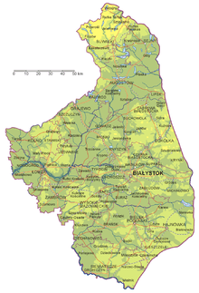
Podlaskie Voivodeship
- This is an article about a present administrative unit of Poland. For historical units, see History of Podlaskie Voivodeship.
| Podlaskie Voivodeship Polish: Województwo podlaskie | |||||
|---|---|---|---|---|---|
| Voivodeship | |||||
|
| |||||
| |||||
.png) Location within Poland | |||||
| Coordinates (Białystok): 53°7′N 23°10′E / 53.117°N 23.167°ECoordinates: 53°7′N 23°10′E / 53.117°N 23.167°E | |||||
| Country |
| ||||
| Capital | Białystok | ||||
| Counties | |||||
| Government | |||||
| • Type | Voivodeship | ||||
| • Body | Podlaskie Regional Assembly | ||||
| • Voivode | Maciej Żywno | ||||
| • Marshal | Jarosław Dworzański | ||||
| • President | Bogdan Dyjuk (PSL) | ||||
| Area | |||||
| • Total | 20,180 km2 (7,790 sq mi) | ||||
| Population (30-06-2014) | |||||
| • Total | 1,193,348 | ||||
| • Density | 59/km2 (150/sq mi) | ||||
| • Urban | 712,675 | ||||
| • Rural | 484,935 | ||||
| Car plates | B | ||||
| Website | bialystok.uw.gov.pl | ||||
| |||||

Podlaskie Voivodeship or Podlasie Province[1] (Polish: Województwo podlaskie, [vɔjɛˈvut͡stfɔ pɔdˈlaskʲɛ]) is a voivodeship (province) in northeastern Poland. It borders on Masovian Voivodeship to the west, Warmian-Masurian Voivodeship to the northwest, Lublin Voivodeship to the south, the Belarusian Voblasts of Grodno and Brest to the east, the Lithuanian Counties of Alytus and Marijampolė to the northeast, and the Kaliningrad Oblast of Russia to the north.
The capital of Podlasie Province is Białystok. The province was created on 1 January 1999, pursuant to the Polish local government reforms adopted in 1998, from the former Białystok and Łomża Voivodeships and the eastern half of the former Suwałki Voivodeship
Etymology
The voivodeship takes its name from the historic region of Poland called Podlasie.
There are two opinions regarding the origin of the region's name. People often derive it from the Slavic les or las, meaning "forest", i.e., it is an area "by the wood(s)" or an "area of forests", which would bring Podlasie close in meaning to adjacent Polesia. This theory has been questioned, as it does not properly take into consideration the vowel shifts "a" > "e" > "i" in various Slavic languages (in fact, it mixes vowels form different languages). Heavily-wooded Podlasie is home to the primal Białowieża Forest and National Park, habitat of the European wisent bison and tarpan.
A second view holds that the term comes from the expression pod Lachem, i.e., "under the Poles" (see: Lechia). Some claim it to mean "under Polish rule", which does not seem historically sound, as the area belonged to the Grand Duchy of Lithuania until 1569, and the southern part of it—until 1795.
A better variant of the latter theory holds that the name originates from the period when the territory was within the Trakai Voivodeship of the Grand Duchy of Lithuania, along the border with Mazovia Province, primarily a fief of the Poland of the Piasts, and later part of the Kingdom of Poland of the Jagiellons. Hence pod Lachem would mean "near the Poles", "along the border with Poland". The historical Lithuanian name of the region, Palenkė, has exactly this meaning.
History
The voivodeship was created on January 1, 1999, out of the former Białystok and Łomża Voivodeships and the eastern half of the former Suwałki Voivodeship, pursuant to the Polish local government reforms adopted in 1998.
Geography
It has a varied landscape, shaped in the north by Baltic glaciation, the rest by Middle Poland glaciation. The highest peaks are in the north (Rowelska Top - 298 m), where the landscape is dominated by a hilly lake district. Lakeland: Zachodniosuwalskie, Wschodniosuwalskie, Ełckie) and Sandrowy lake district (Augustów Plain) in the central and southern pre-glacial plains prevail (plateaus: Kolneńska, Białystok, Wysokomazowiecka, Drohiczynska, Sokólskie Hills, Międzyrzecko łomżyński, Plain Bielsko), varied in topography with small basins and river valleys. Kurpie lie on the west edge of the outwash plains. Sand, gravel, clay, moraine, and in the valleys and basins of the rivers silt, sand and river peat predominate on the surface.
Environment

The vast forests (Białowieża, Augustów, Knyszyń, Kurpiowska), some of which are the only ones in Europe to have retained their original character, contain a unique wealth of flora and fauna. The vegetation of the region is extremely diverse, which contributes to the richness of the animal world. Visitors can also see moose, wolves, lynx and bison living in the Białowieża Forest and Knyszyń Forest.
Podlaskie has the lowest population density of the sixteen Polish voivodeships, and its largely unspoiled nature is one of its chief assets. Around 30% of the area of the voivodeship is under legal protection. The Polish part of the Białowieża Forest biosphere reserve (also a World Heritage Site) is in Podlaskie. There are four National Parks (Białowieża, Biebrza, Narew and Wigry), three Landscape Parks (Knyszyń Forest, Łomża and Suwałki), 88 nature reserves, and 15 protected landscape areas. The voivodeship constitutes a part of the ecologically clean area known as "the Green Lungs of Poland".
Climate
Podlaskie has a Warm Summer Continental or Hemiboreal climate (Dfb) according to the Köppen climate classification system, which is characterized by warm temperatures during summer and long and frosty winters. It is substantially different from most of the other Polish lowlands. The region is one of the coldest in Poland, with the average temperature in January being -−5 °C (23 °F). The average temperature in a year is 7 °C (45 °F). The number of frost days ranges from 50 to 60, with frost from 110 to 138 days and the duration of snow cover from 90 to 110 days. Mean annual rainfall values oscillate around 550 millimetres (21.7 in), and the vegetation period lasts 200 to 210 days.[2]
Podlaskie is the coldest region of Poland, located in the very northeast of the country near the border with Belarus and Lithuania. The region has a continental climate which is characterized by high temperatures during summer and long and frosty winters. The climate is affected by the cold fronts which come from Scandinavia and Siberia. The average temperature in the winter ranges from -15 °C (5 °F) to -4 °C (24.8 °F).[3]
| Climate data for Białystok | |||||||||||||
|---|---|---|---|---|---|---|---|---|---|---|---|---|---|
| Month | Jan | Feb | Mar | Apr | May | Jun | Jul | Aug | Sep | Oct | Nov | Dec | Year |
| Record high °C (°F) | 12 (54) |
16 (61) |
20 (68) |
24 (75) |
30 (86) |
30 (86) |
33 (91) |
32 (90) |
28 (82) |
22 (72) |
12 (54) |
11 (52) |
33 (91) |
| Average high °C (°F) | −1 (30) |
0 (32) |
4 (39) |
11 (52) |
17 (63) |
20 (68) |
21 (70) |
21 (70) |
16 (61) |
10 (50) |
3 (37) |
1 (34) |
10.3 (50.5) |
| Average low °C (°F) | −6 (21) |
−6 (21) |
−2 (28) |
1 (34) |
7 (45) |
10 (50) |
12 (54) |
11 (52) |
7 (45) |
3 (37) |
0 (32) |
−3 (27) |
2 (36) |
| Record low °C (°F) | −34 (−29) |
−25 (−13) |
−23 (−9) |
−7 (19) |
−3 (27) |
1 (34) |
5 (41) |
2 (36) |
−4 (25) |
−10 (14) |
−16 (3) |
−26 (−15) |
−34 (−29) |
| Average precipitation mm (inches) | 30 (1.18) |
20 (0.79) |
30 (1.18) |
30 (1.18) |
50 (1.97) |
70 (2.76) |
70 (2.76) |
70 (2.76) |
50 (1.97) |
40 (1.57) |
40 (1.57) |
40 (1.57) |
580 (22.83) |
| Average precipitation days | 8 | 7 | 8 | 8 | 8 | 10 | 10 | 9 | 9 | 8 | 10 | 10 | 106 |
| Average rainy days | 7 | 7 | 8 | 9 | 7 | 8 | 8 | 7 | 8 | 9 | 9 | 6 | 93 |
| Average snowy days | 9 | 10 | 7 | 3 | 0 | 0 | 0 | 0 | 0 | 0 | 5 | 7 | 41 |
| Mean monthly sunshine hours | 21 | 54 | 139 | 138 | 207 | 236 | 217 | 205 | 162 | 97 | 27 | 20 | 1,523 |
| Source #1: Weatherbase [4] | |||||||||||||
| Source #2: ClimateData.eu[5] | |||||||||||||
Subdivisions and Białystok Metropolitan Region
Podlaskie Voivodeship is divided into 17 counties (powiats): 3 city counties and 14 land counties. These are further divided into 118 gminas.
Metropolitan Białystok was designated by the Voivodeship of the Regulation No. 52/05 of 16 May 2005 [6] in order to help economically develop the region. In 2006, the metropolitan area population was 450,254 inhabitants.[7] It covers an area of 1.521 km ². For one km2, there are about 265 people. Among urban residents are more women - 192 thousand. on 100 men, 108 women on average. The municipalities adjacent to Białystok are slowly erecting their dispensers and losing their agricultural character, becoming the residential suburban neighborhoods.
Demographics
Podlaskie is the land of the confluence of cultures – Polish, Belarusian, Ukrainian and Lithuanian – and is indicative of the ethnic territories limits. Eastward of Podlaskie lie historic Polish lands (Belarusian, while westward ethnically non-West Ruthenian (Ukrainian and Belarusian) and non-Lithuanian lands too. Today, mainly Polish and Ruthenian (Ukrainian and Belarusian) is spoken in Podlaskie, while Lithuanian is preserved by the small but compact Lithuanian minority concentrated in the Sejny County.
At the end of 2009 in Podlaskie Voivodeship there were 1,189,700 inhabitants, 3.1 per cent of the total population of Poland. The average density of the population, the number of the population per 1 km2, was 59. The urban population in the same period was 60.2 per cent of the total number of inhabitants of the voivodeship, where the percentage of females in the total population amounted to 51.3 per cent. A statistical inhabitant of Podlasie was 37.7 years old, whereas in 2008 – 37.5 years old. The latest population projection predict consistent decrease in the population in Podlaskie Voivodeship. In the next 26 years it will decrease by 117 thousand persons due to the aging of the population.
Transportation
Culture
Podlaskie is the most diverse of all Polish voivodships. The area has been inhabited for centuries by members of different nations and religions: Poles, Jews, Belarusians, Lithuanians, Ukrainians, Rusyns, Gypsies, Lipka Tatars and Filippians.
Many places of religious worship remain:
- An 18th-century former Carmelite monastery on Wigry Lake
- A former Jesuit complex in Drohiczyn
- Christ's Transfiguration Orthodox church on the Holy Mount of Grabarka
- Saint Nicolaus the Miracle Worker Orthodox church in Białystok
- A 17th-century synagogue in Tykocin
- The oldest Polish mosque in Kruszyniany
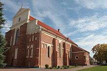
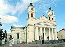
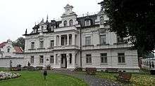
Historic sites
.jpg)

Middle Ages
- St. Michael and John the Baptist Church in Łomża (1504–26)
Renaissance
- The ruins of the Royal Castle in Tykocin (15th century)
- The Jewish cemetery in Tykocin (16th century)
- Monastery of the Annunciation in Suprasl (16th–18th centuries)
Baroque
- Dominican Convent of the Visitation of the Blessed Virgin Mary Church in Sejny (1610–19)
- Old Parish Church in Białystok (1617–26)
- Synagogue (1642) and the Talmud house in Tykocin (18th century)
- Trzewiczkowych Carmelite Monastery with the Church of Our Lady of Mount Caramel in Bielsk Podlaski (mid-17th century)
- Branicki Palace in Białystok (17th–18th centuries)
- Summer residence Branicki in Choroszcz (1752–59)
- Holy Trinity Church in Tykocin (1742–50)
- Church of the Assumption of the Virgin Mary in Siemiatycze (1719–27)
- Monastery of the Dominican church of St. And St. John the Baptist. Stephen Martyr in Choroszcz (mid-18th century)
- Capuchin Monastery in Łomża (1770–98)
- Old Town Hall in Bielsk Podlaski (1776–80)
- Sokółki Palace in Pawłowiczch near Sokółka
- Synagogue in Orla
- Bernardine Monastery in Tykocin (1771–91)
- The team Stawiski Franciscan monastery (17th-19th centuries)
Classicism
- Basilica. Birth of the Virgin and St. Nicholas in Bielsk Podlaski (1780)
- Cathedral of St.. Nicholas in Białystok (1843–46)
- Church of Sts. Kolnie Anne (1834–39)
- Co-cathedral of St. Alexander in Suwałki (1825)
- Classical brick mansion in Mały Płock (1835)
- Church of Sts. Anthony in Sokółka (1848)
- Cemetery Cathedral in Łomża
- Synagogue in Kolno (second half of 18th century)
19th century

- Lubomirski Palace in Białystok (second half of 19th century)
- Hasbach Palace in Białystok (late 19th century)
- The palace and park in Buchholtzów Suprasl (1892–1903)
- Team Becker factory in Białystok (19th and early 20th century)
- The fence and gate parafialno-municipal cemetery in Kolno (1809)
- Church in the Parish and (first half of 19th century)
- Catholic Parish in Grabowo (first half of 19th century)
- The Jewish cemetery in Kolno (1817)
- The Jewish cemetery in Stawiski (first half of 19th century)
- Parish Church p.w. St. Adalbert in m (first half of 19th century)
- The team mail Stawiski (2nd quarter of 19th century)
- Neo-Baroque bell tower at the church brick church. St. Anne Kolnie (1862)
- Buildings of the monastery of SS. Benedictine in Łomża (1863)
- Church of the Assumption in Łomża (1877)
- Roman Catholic Cemetery in Poryte (second half of 19th century)
- Church of the Holy Trinity in Zambrów (1879)
- Church of the Holy Trinity in Grajewo (1882)
- Church of Sts. John the Baptist in Wysokie Mazowiecki (1888)
- Building Seminar in Łomża(1866)
- Town Hall in Łomża (1822–23)
- Numerous monuments Street. Dwornej in Łomża
- Manor in Wojnówka
- Basilica of the Assumption in Białystok (1900–05, neo-Gothic)
- The Church of St.Adalbert in Białystok (1906–12)
- The Church of St. Rocha in Białystok (1926–47, modernist)
- Church of the Sacred Heart of Jesus in Augustów (1905–11 eclectic)
- The Church of Our Lady of Częstochowa and St. Casimir in Mońki (1921–35)
- Saints' Church of the Apostles Peter and Paul in Łapy (1918–27)
- Fortress in Osowiec
- Polish Tatar (see "Islam in Poland") wooden mosque and Muslim cemetery in the village of Bohoniki
Economy
The following are general economic indicators for Podlaskie Voivodeship:[8]
- Population (as of 30 September 2009) - 1,190,735
- Average paid employment in enterprise sector (November 2009) - 95896
- Average monthly gross wages and salaries in enterprise sector (November 2009) - 2,813.05 zł
- Unemployment rate (as of the end of November 2009) - 12,0%
- Dwellings completed in November 2009 - 661
- Procurement of milk (November 2009) - 126.8 mln l
- National economy entities from the REGON register, excluding persons tending private farms (as of the end of November 2009) - 89,654
According to REGON register in the year 2002 there were around 95 thousand companies registered in Podlaskie region (97% of them in private sector), dealing with;
- Trade and servicing – 33.2%
- Providing services to real estates and companies – 11.8%
- Construction – 10.5%
- Industrial processing – 9.7%
- Transport 8.3%
- Agriculture, hunting and forestry 4.5%
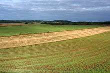
Agriculture
Arable land constitutes around 60% of the total area of the region – most of which is ploughland (around 40%), forests, meadows and pastures. Over 120 000 farms are registered, roughly half of which are small farms of 1–5 ha and medium-sized farms of 5–10 ha. The smaller farms prefer intensive production (gardening, orcharding), whereas the larger ones engage in cattle and crop production. The cattle-raising farms are mainly oriented towards milk production.
The natural conditions of the region are conducive to the development of organic growing, which at present is practised by around 100 farms. Over 600 farms in the region offer agritourist services.[9]
Government
The voivodeship's seat is the city of Białystok. Like all voivodeships, it has a government-appointed Provincial Governor[10] (Polish: wojewoda), as well as an elected Regional Assembly (sejmik) and of the executive elected by that assembly, headed by the voivodeship marshal (marszałek województwa). Administrative powers and competences are statutorily divided between these authorities.
Cities and towns
The voivodeship contains 40 cities and towns. These are listed below in descending order of population (according to official figures for 2006[11]
-
 Białystok (295,210)
 -
 Suwałki (69,234)
 -
 Łomża (63,572)
 -
 Augustów (30,054)
 -
 Bielsk Podlaski (26,876)
 -
 Zambrów (22,700)
 -
 Grajewo (22,651)
 -
 Hajnówka (22,072)
 -
 Sokółka (18,888)
 -
 Łapy (16,583)
 -
 Siemiatycze (15,169)
 -
 Kolno (10,751)
 -
 Mońki (10,455)
 -
 Czarna Białostocka (9,596)
 -
 Wysokie Mazowieckie (9,257)
 -
 Wasilków (8,967)
 -
 Dąbrowa Białostocka (6,147)
 -
 Sejny (5,934)
 -
 Choroszcz (5,416)
 -
 Ciechanowiec (4,898)
 -
 Supraśl (4,578)
 -
 Brańsk (3,794)
 -
 Szczuczyn (3,564)
 -
 Michałowo (3,343)
 -
 Knyszyn (2,835)
 -
 Krynki (2,709)
 -
 Czyżew (2,670)
 -
 Lipsk (2,498)
 -
 Stawiski (2,442)
 -
.svg.png) Zabłudów (2,400)
Zabłudów (2,400) -
 Szepietowo (c. 2,400)
 -
 Suchowola (2,243)
 -
 Drohiczyn (2,086)
 -
 Nowogród (2,014)
 -
 Goniądz (1,910)
 -
 Jedwabne (1,901)
 -
 Tykocin (1,893)
 -
 Rajgród (1,673)
 -
 Kleszczele (1,432)
 -
 Suraż (982)
External links
References
- ↑ Arkadiusz Belczyk, Tłumaczenie polskich nazw geograficznych na język angielski [Translation of Polish Geographical Names into English], 2002-2006.
- ↑ Białystok - Klimat - INFORMATOR BIAŁOSTOCKI
- ↑ "Weatherbase: Historical Weather for Białystok, Poland". Retrieved September 27, 2016.
- ↑ "Weatherbase: Historical Weather for Białystok, Poland". Retrieved September 27, 2016.
- ↑ "Climate Bialystok - Poland". Retrieved September 27, 2016.
- ↑ Rozporządzenie Nr 52/05 Wojewody Podlaskiego z dnia 16 maja 2005 r. w sprawie wyznaczenia aglomeracji Białystok (Dz. Urz. Woj. Podl. Nr 130, poz. 1547)
- ↑ Rozporządzenie Nr 5/06 Wojewody Podlaskiego z dnia 29 września 2006 r. w sprawie wyznaczenia aglomeracji Białystok (Dz. Urz. Woj. Podl. Nr 244, poz. 2383)
- ↑ "Statistical Office in Białystok". Retrieved January 8, 2010.
- ↑ "Podlaski Urząd Wojewódzki - Podlasie Voivodeship Office" (in Polish). 2007.
- ↑ "Ministry of Foreign Affairs (MFA) Agreement Article XI, Coordination with Polish Authorities" (in Polish). 2007-12-31.
- ↑ "Central Statistical Office (GUS) Population: Size and Structure by Administrative Division" (in Polish). 2007-12-31.
 |
|
|
|
|
| |
|
| ||
| ||||
| | ||||
| |
| City counties |  | |
|---|---|---|
| Land counties | ||