Podlaskie Voivodeship (1513–1795)
| Podlaskie Voivodeship Polish: Województwo Podlaskie | |||||
| Voivodeship of Poland¹ | |||||
| |||||
|
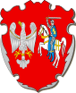
Coat of arms | |||||
 the Polish–Lithuanian Commonwealth in 1619. | |||||
| Capital | Drohiczyn | ||||
| History | |||||
| • | Established | 1513 | |||
| • | Third partition | 24 October 1795 | |||
| Political subdivisions | 3 lands, which were equivalent to counties | ||||
| ¹ Voivodeship of the Kingdom of Poland in the Polish-Lithuanian Commonwealth. Voivodeship of Grand Duchy of Lithuania before 1569. | |||||
The Podlaskie Voivodeship was formed in 1513 by Sigismund I the Old as a voivodeship in the Grand Duchy of Lithuania, from a split off part of the Trakai Voivodeship.[1] After Lithuania's union with the Kingdom of Poland in 1569 and formation of the Polish–Lithuanian Commonwealth, the voivodeship was transferred to the Polish Crown,[2][3] where it belonged to the Lesser Poland Province of the Polish Crown.
In ca. 1274, the historical Podlasie region was connected to the Grand Duchy of Lithuania. In 1391 the Polish King and Lithuanian Grand Duke Jogaila attempted to transfer the region to Duke Vytautas' brother-in-law, Janusz I of Warsaw, Duke of Masovia, but from 1413 on Podlaskie was managed as part of the Grand Duchy's Trakai Voivodeship. After the administrative reform of 1514, Podlaskie was isolated from Trakai Voivodeship as a separate voivodeship, with the capital at the town of Drohiczyn. In 1569, King of Poland and Grand Duke of Lithuania Sigismund II Augustus transferred Podlaskie voivodeship, together with the Kiev, Volyn and Braclaw Voivodeships to the Polish Crown. Podlaskie remained part of Poland until the Partitions of Poland. In 1795 it was divided between the Kingdom of Prussia (north) and Russian Empire (lunch), but in 1807 its whole territory was annexed by Russia, where it remained in 1918.
Zygmunt Gloger gives the following description of Podlasie Voivodeship:
“Historic Podlasie stretched from north to south for some 30 miles, and was located between Mazovia and Rus principalities of Brzesc and Grodno (...) It was a sparsely populated province, covered by dense forests, with four major rivers: the Biebrza, the Narew, the Bug and the Krzna. Due to population growth in Mazovia and Rus, Podlasie became a settlement area - Mazovians settled near Tykocin, Rajgrod and Goniadz, while Ruthenians settled near Bielsk Podlaski. In northern districts of Podlasie, near Augustow, the Yotvingians resided (...) After the 1241 Mongol invasion of Poland, Podlasie turned into a desert, with population decimated by Asiatic hordes. Poles did not return here until the late 13th century, despite the fact that the province was already controlled by the Grand Duchy of Lithuania (...)
King Sigismund I the Old created Podlasie Voivodeship, which was part of Lithuania, but in 1569 was transferred to Poland, after the Union of Lublin (...) After the third partition of Poland, most of the voivodeship was annexed by the Kingdom of Prussia. When in 1815, Congress Poland was divided into new provinces, the Podlasie Voivodeship was re-created, but it covered only a small part of Podlasie itself, together with areas belonging to historic Mazovia, Polesie and Lesser Poland. As a result, boundaries of Podlasie proper changed.
In the Polish-Lithuanian Commonwealth, the voivodeship had two senators, who were the voivode and the castellan of Podlasie. It was divided into three lands, those of Drohiczyn, Bielsko and Mielnik. Each land had its own regional government, and elected two envoys to the Sejm. Furthermore, the voivodeship sent two deputies to the Lesser Poland Tribunal at Lublin or Radom”.
Administrative Subdivisions
The Voivodeship consisted of the following ziemias:
- Bielsk Land (Polish: ziemia bielska), Bielsk). Local sejmiks took place in Bielsk, where the szlachta elected two deputies of the Sejm,
- Drohiczyn Land (Polish: ziemia drohicka), Drohiczyn). Local sejmiks took place in Drohiczyn, electing two deputies of parliament,
- Mielnik Land (Polish: ziemia mielnicka), Mielnik). Local sejmik took place in Mielnik, where two deputies were elected.
Heraldry
The emblem of the region is connected by two arms of Polish and Lithuanian – an eagle without a crown on a red field, and Lithuanian knight.
Voivodes
The governor of the Podlaskie Voivodeship was first located in Bielsk Podlaski, but later moved to Drohiczyn.
Voivodes included
- Jan Wodyński (1613–1616)
- Andrzej Chądzyński (1625–1633)
- Paweł Szczawinski (February 1633 – 1634)
- Stanisław Niemira (1634–1646/1648)
- Iwan Sapieha (ur. ok. 1450, zm. 1517) 1513 – 1517
- Janusz Kostewicz (ur. 1468, zm. 1527) 1520 – 1527
- Iwan Sapieha (ur. 1486, zm. 1546) 1529 – 1541
- Mikołaj Pac (ur. 1497, zm. 1551) 1543 – 1551
- Mikołaj Narbutt (zm.1555) 1551 – 1555
- Paweł Sapieha (zm. 1579) 1555 – 1558,also the Voivode of smoleński
- Bazyli Tyszkiewicz (ur. 1492, zm. 1571) 1558 – 1569, also the Voivode of smoleński
- Mikołaj Kiszka (ur. 1524, zm. 1587) 1569 – 1587
- Stanisław Radzymiński (ur. 1552, zm. 1591) 1588 – 1591
- Janusz Zasławski (ur. 1561, zm. 1629) 1591 – 1604, also the Voivode of wołyński
- Tomasz Gostomski (ur. 1569, zm. 1623) 1605 – 1605, also the Voivode of mazowiecki
- Jan Zbigniew Ossoliński (ur. 1555, zm. 1623) 1605 – 1613, also the Voivode of sandomierski
- Jan Wodyński ( zm. 1616) 1613 – 1616
- Stanisław Warszycki (ur. 1577, zm. 1617) 1616 – 1617
- Wojciech Niemira (zm. 1625) 1617 – 1625
- Andrzej Chądzyński (ur. 1561, zm. 1631) 1625 – 1631
- Paweł Szczawiński (zm. 1634) 1633 – 1634
- Stanisław Niemira (ur. 1597, zm. 1642/48) 1634 – 1648
- Paweł Warszycki (zm. 1660) 1649 – 1652, also the Voivode of mazowiecki
- Prokop Leśniowolski (ur. 1588, zm. 1653) 1652 – 1653
- Jan Piotr Opaliński (ur. 1601, zm. 1665) 1653 – 1661, also the Voivode of kaliski
- Wojciech Emeryk Mleczko (ur. ok. 1625, zm. 1673) 1665 – 1673
- Wacław Leszczyński (ur. 1626, zm. 1688) 1673 – 1688
- Marcin Oborski 1688 – 1698
- Stefan Mikołaj Branicki (ur. 1643, zm. 1709) 1699 – 1709
- Stanisław Mateusz Rzewuski (ur. 1660, zm. 1728) 1710 – 1728, also the Voivode of bełski, hetman polny koronny
- Michał Józef Sapieha 1728 – 1738
- Karol Józef Hiacynt Sedlnicki 1738 – 1745, also podskarbi wielki koronny
- Michał Antoni Sapieha (ur. 1711, zm. 1760) 1746 – 1752, also podkanclerzy litewski
- Michał Józef Rzewuski (ur. 1699, zm. 1770) 1752 – 1762
- Bernard Stanisław Gozdzki (ur. 1704, zm. 1771) 1762 – 1771
- Antoni Miączyński (ur. 1691, zm. 1774) 1771 – 1774
- Józef Salezy Ossoliński (ur. 1744, zm. 1797) 1774 – 1790
- Tomasz Aleksandrowicz (ur. 1735, zm. 1794 1790 – 1794
References
 |
| |
| ||

Coordinates: 52°23′44″N 22°39′28″E / 52.395496°N 22.657896°E