Podolia Governorate
| Podolia Governorate Подільська губернія Подольская губерния (Podolskaya guberniya) | |||||
| Governorate of the Russian Empire, Ukraine | |||||
| |||||
|
Coat of arms | |||||
 | |||||
| Capital | Kamenets-Podolskiy since 1914 Vinnytsia | ||||
| History | |||||
| • | Second Partition of the Polish-Lithuanian Commonwealth | 1793 | |||
| • | Abolished | 1 August 1925 | |||
| Area | 42.000 km2 (16 sq mi) | ||||
| Political subdivisions | Governorates of the Russian Empire | ||||

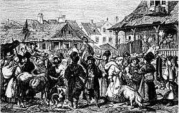
The Podolia Governorate or Government of Podolia, set up after the Second Partition of Poland, comprised a governorate (guberniya) of the Russian Empire from 1793 to 1917, of the Ukrainian People's Republic from 1917 to 1921, and of the Ukrainian SSR from 1921 to 1925.
History
The Government of Podolia was established right after the Second Partition of Poland in place of the former Podole and Bracław Voivodeships in 1793.
Location
The Podolian Governorate occupied the southwestern frontier of the former Russian empire, bordering Austria-Hungary, and had an area of about 42,000 km². The administrative centre was Kamenets-Podolskiy until 1914 when it moved to Vinnytsia.
Podolia Governorate was one of the three governorates of the Southwestern Krai administration. In 1917 it was recognized by the Russian Provisional Government to be governed by the General Secretariat of Ukraine as the representative of the Russian Provisional Government in the region.
Administrative division
Uyezd subdivision
Until 1918 the governorate consisted of 12 uyezds (counties):
- Balta uyezd
- Bratslav uyezd
- Vinnitsia uyezd
- Gaysin uyezd
- Kamenets uyezd
- Letichev uyezd
- Litin uyezd
- Mogilev uyezd
- Olgopol uyezd
- Proskurov uyezd
- Ushytsa uyezd
- Yampol uyezd
Okruha subdivision
On 12 April 1923 all uyezds (counties) were transformed into okruhas (counties), while volosts (districts) – into raions (districts). Okruhas served as a subdivision of government until it was abolished on 1 August 1925. Together with the government of Podilia, the Haisyn okruha was dissolved as well. Some territory of Tulchyn okruha were included into the newly formed Moldavian Autonomous Soviet Socialist Republic.
- Vinnytsia
- Haisyn
- Kamianets
- Mohyliv
- Proskuriv
- Tulchyn
Principal cities
Russian Census of 1897:
- Kamenets/Podolsky – 35 934 (Jewish – 16 112, Ukrainian – 9 755, Russian – 7 420)
- Vinnitsa – 30 563 (Jewish – 11 456, Ukrainian – 10 862, Russian – 5 206)
- Balta – 23 363 (Jewish – 13 164, Russian – 5 385, Ukrainian – 4 124)
- Proskurov – 22 855 (Jewish – 11 369, Ukrainian – 4 425, Russian – 3 483)
- Mogilev/Dnestr – 22 315 (Jewish – 12 188, Ukrainian – 6 512, Russian – 2 668)
- Zhmerinka – 12 908
- Khmelnik – 11 657 (Jewish – 5 979, Ukrainian – 5 375, Polish – 150)
Smaller cities
- Bar – 9 982 (Jewish – 5 764, Ukrainian – 3 332, Russian – 485)
- Litin – 9 420 (Jewish – 3 828, Ukrainian – 3 047, Russian – 2 126)
- Gaysin – 9 374 (Jewish – 4 322, Ukrainian – 3 946, Russian – 884)
- Olgopol – 8 134 (Ukrainian – 4 837, Jewish – 2 465, Russian – 625)
- Bratslav – 7 863 (Jewish – 3 275, Ukrainian – 2 608, Russian – 1 782)
- Letichev – 7 248 (Jewish – 4 105, Ukrainian – 1 719, Polish – 741)
- Yampol – 6 605 (Ukrainian – 3 282, Jewish – 2 819, Russian – 275)
- Novaya Ushytsa – 6 371 (Jewish – 2 214, Russian – 2 120, Ukrainian – 1 836)
- Staraya Ushytsa – 4 176 (Ukrainian – 2 488, Jewish – 1 584, Polish – 57)
- Salnitsa – 3 699 (Ukrainian – 2 758, Jewish – 899, Polish – 19)
- Verbovets – 2 311 (Ukrainian – 1 282, Jewish – 661, Polish – 326)
Language
The Imperial census of 1897[1] produced the following statistics. Bold type marks languages spoken by more people than the state language. In 1897 3,018,299 people lived in the governorate of Podolia.
| Language | Number | percentage (%) | males | females |
|---|---|---|---|---|
| Ukrainian | 2,442,819 | 80.93 | ||
| Yiddish | 369,306 | 12.24 | ||
| Russian | 98 984 | 3.28 | ||
| Polish | 69 156 | 2.29 | ||
| Romanian[2] | 26 764 | 0.89 | ||
| German | 4 069 | 0.13 | ||
| Tatar | 2 296 | 0.08 | ||
| Bashkir | 1 113 | 0.04 | ||
| Other[3] | 3 706 | 0.12 | ||
| Persons who did not identify their native language |
73 | <0.01 |
The cities had 221,870 inhabitants, comprising about 7.35% of the total population. About 46.06% of the urban population consisted of Jews, 32.54% of Ukrainians, 15.03% of Russians, and 4.90% of Poles.
Religion
The Imperial census of 1897[4] reported:
| Religion | Number | percentage (%) | males | females |
|---|---|---|---|---|
| Eastern Orthodox | 2,358,497 | 78.14 | ||
| Judaism | 370,612 | 12.28 | ||
| Roman Catholics | 262,738 | 8.70 | ||
| Old Believers | 18 849 | 0.62 | ||
| Other[5] | 7 603 | 0.25 |

- Religious structures
- Churches
- Eastern Orthodox 1645
- Roman Catholic (kosciol) 202
- Lutheran 4
- Monasteries
- Eastern Orthodox 7 (male), 4 (female)
- Synagogues 89
- other Shul(s) 438
- Mosque(s) 1
References
- ↑ Language Statistics of 1897 (Russian)
- ↑ including Moldavian language
- ↑ Languages, number of speakers which in all gubernia were less than 1000
- ↑ Religion Statistics of 1897 (Russian)
- ↑ Religions, number of believers which in all gubernia were less than 10000
See also
Coordinates: 48°40′50″N 26°34′50″E / 48.6806°N 26.5806°E