San (river)
| San | |
| River | |
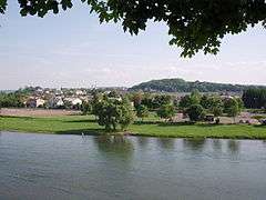 San River, Sanok, 2005 | |
| Countries | Poland, Ukraine |
|---|---|
| Part of | Vistula River |
| Source | Uzhok Pass |
| - location | Piniashkovy Mount, Bukovec Mountains, Ukraine |
| - elevation | 900 m (2,953 ft) |
| - coordinates | 49°00′19″N 22°52′43″E / 49.00528°N 22.87861°E |
| Mouth | Vistula River |
| - location | Dąbrówka Pniowska, Sandomierz Basin, Poland |
| - coordinates | 50°44′15″N 21°50′43″E / 50.73750°N 21.84528°ECoordinates: 50°44′15″N 21°50′43″E / 50.73750°N 21.84528°E |
| Length | 443 km (275 mi), S → N |
| Width | 10 km (6 mi) |
| Basin | 16,861 km2 (6,510 sq mi) |
| Discharge | |
| - average | 124 m3/s (4,379 cu ft/s) |
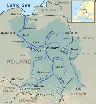 San River in Vistula watershed | |
| Wikimedia Commons: San in Sanok | |

.jpg)
The San (Polish: San; Ukrainian: Сян Sian; German: Saan) is a river in southeastern Poland and western Ukraine, a tributary of the Vistula River, with a length of 443 km (it is the 6th-longest Polish river) and a basin area of 16,861 km2 (14,390 km2 of it in Poland).
Etymology
San, in proto-Indoeuropean languages, means "speed" or "rapid stream." In Celtic languages, San means "river."[1][2][3][4][5]
Course
The San arises in the Carpathian Mountains near the village of Sianky, at an elevation of 900 metres, exactly on the Polish-Ukrainian border[6] (49°00′10″N 22°52′30″E / 49.00278°N 22.87500°E) and on the continental watershed, and forms the border between Poland and Ukraine for approximately its first 50 km. Poland's largest artificial lake, Lake Solina, was created by a dam on the San River near Lesko.
Tributaries
|
Left tributaries |
Right tributaries
|
History of the region
Historical records first mention the river in 1097 as Sanъ, reku Sanъ, k Sanovi; then as nad Sanomъ (1152) and Sanu (1287). On the old maps of the Ruthenian Voivodeship, Poland 1339–1772: "San" (1339), San (1372), "Szan" (1406), "Sanok" (1438), "Saan" (1439), "Sayn" (1445), "San" (1467), "Szan" (1517), "Schan" (1526).[7]
Humans had first settled the southeastern region of present-day Poland (the Subcarpathian Voivodeship or Podkarpacie) in prehistoric times. In the pre-Roman era various tribes, including the Celts, Goths and Vandals (Przeworsk culture and Puchov culture)[8] overran the area. After the fall of the Roman Empire, Hungarians and Slavs invaded the area.
The San valley must have become an important trade-route and axis of human settlement as early as the 9th or 10th century. The region subsequently became part of the Great Moravian state. Upon the invasion of the Hungarian tribes into the heart of the Great Moravian Empire around 899, the Lendians of the area declared their allegiance to the Hungarian Empire. The region then became a site of contention between Poland, Kievan Rus and Hungary starting in around the 9th century. This area was mentioned for the first time in 981 (by Nestor), when Volodymyr the Great of Kievan Rus took the area over on his way into Poland. In 1018 it returned to Poland, in 1031 reverted to Rus, and in 1340 was recovered by Casimir III of Poland.
During the years 966–1018, 1340–1772 (the Ruthenian Voivodeship) and 1918–1939, the region was part of Poland. Between 1772 and 1918 it belonged to the Austrian empire, which became the Austro-Hungarian empire when the double monarchy was introduced. This region, including the area west and east of the Subcarpathian Voivodship, was controlled by Austria for almost 120 years. During that time it was known as Galicia.
The San River, which saw many battles in its history, was a battle site during the start of World War II in Europe. At the outset of the German invasion of Poland, Polish forces attempted to defend a line along the San from September 6, 1939, until German forces broke out of their bridgeheads on September 12, 1939.
Cities
- Dynów, Jarosław, Lesko, Leżajsk, Nisko, Przemyśl, Radymno, Rudnik nad Sanem, Sandomierz, Sanok, Sieniawa, Stalowa Wola, Ulanów, Zagórz
See also
References
- ↑ "Puisqu'il est impossible de les enumerer tous citons moins: Brda, Brenna, Bzura, Drwęca, Mroga, Nida, Raba, San, etc. Bzura selon Jan Rozwadowski correspond avec Brigulos, Drwęca aves Druentia, Durance, Nida avec Nidder, Raba avec Raab, San avec Sadne et Seine." [in:] Ethnologia Polona. Instytut Historii Kultury Materialnej (Polska Akademia Nauk). 1981. p. 49.
- ↑ "[...] San lateinische Graphie wie bei Sandomierz, Santok usw. Vgl. altind. sindhu- "Fluß", den irischen GN Shannon und den Maizzufluß Sinn" [in:] Irena Kwilecka. Etnolingwistyczne i kulturowe związki Słowian z Germanami. Instytut Słowianoznawstwa PAN. 1987. ISBN 83-04-02472-1 S. 64.
- ↑ "An adouci en san, eau, rivière; stach, sinueux, qui tourne. Allusion au cours sinueux de la Charente". op. cit. Antiq. de France. [in:] Revue des ëtudes historiques. Société des études historiques. 1835. p.242.; Senne, nom propre de rivière. - Scène, ». L liou on l'on joue. — Seine, sf, sorte de «lot. 17. Cen», sm, impôt. — San, np Sen», sm, jugement [...]". [in:] Dictionnaire de pédagogie et d'instruction primaire. Ferdinand Edouard Buisson. 1883. p. 980.
- ↑ "Le terme sawn « cleft, gully » est rapproché du breton san, saon s.f. « aqueduct, san-dour »." Études celtiques. Société d'Éditions "Les Belles Lettres", 1985 p. 337.
- ↑ "La racine san est à la base des patronymes: Sangnier, Sagne, Sagnolle, Lassassaigne et Delassassaigne dont un ancentre a habitè près d'un marais." [in:] Paul Bailly. Toponymie en Seine-et-Marne: noms de lieux. Editions Amatteis, 1989. p. 77.
- ↑ "PLFOTO - internetowe forum fotograficzne". Retrieved 2 February 2016.
- ↑ Adam Fastnacht, Slownik Historyczno-Geograficzny Ziemi Sanockiej w Średniowieczu (Historic-Geographic Dictionary of the Sanok District in the Middle Ages), Kraków, 2002, ISBN 83-88385-14-3. V. 2. San
- ↑ "It is possible to separate the group of La Tène culture (Celtic settlement) in the Upper Tisza Basin. For the time being there are about 160 sites noted. They can be divided into several distinct categories which include the following: settlements, production areas, sepulchral sites, i.e., burial grounds and single graves as well as various hoards (deposits of coins and tools). Moreover, there are three oppida: Zemplin, Bükkszentlászló and Galish-Lovačka. The chronology of the whole group lies between LT B1-LT D1/D2. Especially interesting is the problem of correspondence between this group and the group of sites in southeast Poland. Material connections are also documented in ancient sources. They allow to identify the group from Upper Tisza as the Anarti tribe and the group from southeast Poland as the Anartophracti, which is a part of the former." [in:] Marek Olędzki. La Tène culture in the Upper Tisza Basin =La Culture de la Tene dans le Bassin de la Haute Tisza. Ethnographisch-archaeologische Zeitschrift. ISSN 0012-7477
Literature
- Geographical Dictionary of the Kingdom of Poland and other Slavic Lands Słownik geograficzny Królestwa Polskiego i innych krajów słowiańskich. tom. X, pages 260 - 263. Warszawa. 1876. (digital edition)
Tributaries of the Vistula River | ||
|---|---|---|
| Forming rivers |
| |
| Main tributaries of the left bank | ||
| Main tributaries of the right bank |
| |
| Distributary | ||