Point Avoid
| Point Avoid South Australia | |
|---|---|
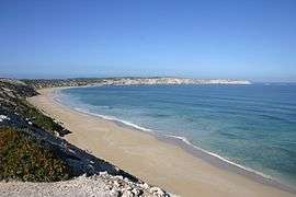 View of Limestone cliffs and beach that finish at Point Avoid | |
 Point Avoid | |
| Coordinates | 34°40′50.1″S 135°19′16.9″E / 34.680583°S 135.321361°ECoordinates: 34°40′50.1″S 135°19′16.9″E / 34.680583°S 135.321361°E |
| Elevation | 46 m (151 ft)[1] |
| Location | 15 km (9 mi) south west of Coffin Bay[2] |
Point Avoid is a headland located at the south eastern extremity of both Coffin Bay Peninsula and Avoid Bay on the west coast of Eyre Peninsula in South Australia about 15 kilometres (9.3 mi) south west of the town of Coffin Bay. It was described in 2012 as being “fronted on all of its seaward sides by limestone cliffs, about 46 metres (151 ft) high, which change abruptly to sand hills E of its S(outhern) extremity.” It was named by Matthew Flinders on 17 February 1802 to acknowledge the navigational hazards present around its shores. The point is currently located within the boundaries of the protected area, the Coffin Bay National Park.[1][2][3][4][5]
References
- 1 2 National Geospatial-Intelligence Agency (NGA) (2010). Pub175, Sailing directions (enroute) north, west, and south coast of Australia (PDF) (10th ed.). National Geospatial-Intelligence Agency. p. 170. Retrieved 16 May 2014.
- 1 2 South Australia. Department of Marine and Harbors (DMH) (1985), The Waters of South Australia, a series of charts, sailing notes and coastal photographs, Dept. of Marine and Harbors, South Australia, p. chart 35, ISBN 978-0-7243-7603-2
- ↑ "Search for feature SA0082065 (Point Avoid, also known as Pointe Feuillee)". Geoscience Australia. Retrieved 27 February 2015.
- ↑ Flinders, Matthew (1966) [1814]. A Voyage to Terra Australis : undertaken for the purpose of completing the discovery of that vast country, and prosecuted in the years 1801, 1802, and 1803 in His Majesty's ship the Investigator, and subsequently in the armed vessel Porpoise and Cumberland Schooner; with an account of the shipwreck of the Porpoise, arrival of the Cumberland at Mauritius, and imprisonment of the commander during six years and a half in that island. (Facsimile ed.). Adelaide; Facsimile reprint of: London : G. and W. Nicol, 1814 ed. In two volumes, with an Atlas (3 volumes): Libraries Board of South Australia. p. 226. Retrieved 27 March 2013.
- ↑ "Parks of the Coffin Bay Area Management Plan" (PDF). Department for Environment and Heritage. 2004. p. 3. Retrieved 21 October 2014.
External links
This article is issued from Wikipedia - version of the 3/2/2016. The text is available under the Creative Commons Attribution/Share Alike but additional terms may apply for the media files.