Pompey's Pillar, Montana
| Pompeys Pillar, Montana | |
|---|---|
| Unincorporated community | |
 Pompeys Pillar, Montana  Pompeys Pillar, Montana | |
| Coordinates: 45°59′29″N 107°57′07″W / 45.99139°N 107.95194°WCoordinates: 45°59′29″N 107°57′07″W / 45.99139°N 107.95194°W | |
| Country | United States |
| State | Montana |
| County | Yellowstone |
| Elevation | 2,874 ft (876 m) |
| Population (2010)[1] | |
| • Total | 272 |
| Time zone | Mountain (MST) (UTC-7) |
| • Summer (DST) | MDT (UTC-6) |
| ZIP code | 59064 |
| Area code(s) | 406 |
| GNIS feature ID | 777090[2] |
.jpg)
Pompeys Pillar is an unincorporated community in Yellowstone County, Montana, United States and has a postal ZIP code (59064).
History
The town of Pompeys Pillar was founded in 1907 and was named after and situated less than a mile east of Pompeys Pillar National Monument, a 150 ft. tall sedimentary rock formation best known for William Clark's inscription of his name and the date July 25, 1806 on its surface. The site also has significant evidence of human activity spanning an estimated 11,000 years.
The town of Pompeys Pillar was first planned out as a railroad station within the Huntley Project, an irrigation project managed by the United States Bureau of Reclamation.
A Catholic church and a Union Congregational church once existed in Pompeys Pillar. The Northern Pacific Railroad connected the town to Billings, about 29 miles southwest. A post office currently operates in the community.
Pompeys Pillar National Monument was created in 2001 and placed under the jurisdiction of the Bureau of Land Management. In 2006 a new visitor's center and museum complex opened, coinciding with the bicentennial of the Lewis and Clark expedition. The site also has a small gift shop and other amenities.[3]
References
- ↑ "American FactFinder". United States Census Bureau. Retrieved 2011-05-14.
- ↑ "Pompey's Pillar". Geographic Names Information System. United States Geological Survey.
- ↑ "History". Friends of Pompey's Pillar.
Municipalities and communities of Yellowstone County, Montana, United States | ||
|---|---|---|
| Cities | 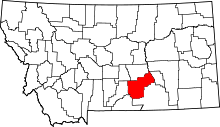 | |
| Town | ||
| CDPs | ||
| Other unincorporated communities | ||
| Indian reservation | ||
| Ghost town | ||
| Footnotes | ‡This populated place also has portions in an adjacent county or counties | |