Port Richmond (Staten Island Railway station)
| Port Richmond | |||||||||||
|---|---|---|---|---|---|---|---|---|---|---|---|
| Former Staten Island Railway rapid transit station | |||||||||||
|
Park Avenue | |||||||||||
| Station statistics | |||||||||||
| Borough | Staten Island | ||||||||||
| Locale | Port Richmond | ||||||||||
| Coordinates | 40°38′21″N 74°07′52″W / 40.6391°N 74.1311°WCoordinates: 40°38′21″N 74°07′52″W / 40.6391°N 74.1311°W | ||||||||||
| Line | SIR North Shore Branch | ||||||||||
| Services | none | ||||||||||
| Platforms | 1 island platform | ||||||||||
| Tracks | 2 | ||||||||||
| Other information | |||||||||||
| Opened | February 23, 1886 | ||||||||||
| Closed | March 31, 1953 | ||||||||||
| Station succession | |||||||||||
| |||||||||||
Port Richmond is a station on the abandoned North Shore Branch of the Staten Island Railway. Located in Port Richmond on a concrete trestle at Park Avenue and Church Street, it has two tracks and an island platform.[1][2][3] The station is located approximately 3 miles (4.8 km) from Saint George Terminal.[4]
History
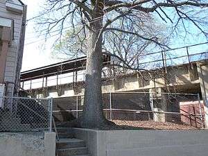
The station was opened by the Baltimore and Ohio Railroad on February 23, 1886 as a wooden surface station, with two high-level side platforms.[5][6] Between Port Richmond and West Brighton, the line crossed an eight-foot high suspension bridge over Bodine Creek. The low clearance of the bridge attracted some individuals to fish and crab from the trestle, leading to several accidents.[7][8] Beginning in 1935, the Port Richmond station and Tower Hill one stop west were elevated onto a concrete viaduct structure known as the Port Richmond Viaduct as part of the grade-crossing elimination project of the SIRT. The new trestle was built on top of the old Bodine Creek bridge, raising the crossing to safer heights. At the time, the one-mile viaduct was claimed to be "the longest in the United States." The new station was opened on February 26, 1937.[5][6][9][10] East of the station, the line returns to grade level after crossing the remnants of Bodine Creek, with the trestle ending at the east end of the Port Richmond Water Pollution Control Plant operated by the NYCDEP.[1][6][11] The station was closed on March 31, 1953, along with the rest of the North Shore Branch and the South Beach Branch.[5] Port Richmond is one of the few stations along the North Shore line standing today, as of June 2013.[1]
The current elevated station was built with a concrete island platform and a metal canopy extending its entire length. The platform measures about 240 feet (73 m) in length, which would fit three cars of the former ME-1 rolling stock (67 feet in length) or of the current R44 SIR cars (75 feet in length). The station has two staircases to street level on opposite ends of the platform; the westernmost at the intersection of Port Richmond Avenue and Ann Street, and the easternmost at Park Avenue and Church Street.[1][2] The trestle remains in good condition, but the former platform and canopy have been weathered and dilapidated due to lack of maintenance.[1][11][12]
Port Richmond is one of the stations to be returned to operation under the proposals for reactivation of the North Shore branch for rapid transit, light rail, or bus rapid transit (BRT) service.[1][2] Computer renderings for the proposed BRT modifications of the station were created by the MTA in 2012.[13][14][15]
One block north of the station on Richmond Terrace is a bus hub known as the Port Richmond Bus Terminal, where the S53, S57, S59, and S66 buses terminate. The S40 and S90 buses, which parallel the North Shore Branch on Richmond Terrace, also stop here. In spite of its name, the terminal consists of three normal NYCDOT bus stops.[1][16][17]
Station layout
| P Platform level |
Westbound | Trackbed |
| Island platform, not in use | ||
| Eastbound | Trackbed | |
| G | Street level | Exit/Entrance |
References
- 1 2 3 4 5 6 7 "NYCT NORTH SHORE ALTERNATIVES ANALYSIS: Alternatives Analysis Report" (PDF). mta.info. Metropolitan Transportation Authority. August 2012. Retrieved 20 July 2015.
- 1 2 3 "North Shore Alternatives Analysis: Rail Alignment Drawings Arlington-St. George" (PDF). mta.info. Metropolitan Transportation Authority. September 2010. Retrieved 20 July 2015.
- ↑ "North Shore Alternatives Analysis: Busway Alignment Drawings Arlington-St. George" (PDF). mta.info. Metropolitan Transportation Authority. September 2010. Retrieved 20 July 2015.
- ↑ Office of Diane J. Savino (2013). "State Senator Diane J. Savino's 2013 Staten Island Railway Rider Report" (PDF). nysenate.gov. New York State Senate. Retrieved 31 July 2015.
- 1 2 3 Leigh, Irvin; Matus, Paul (January 2002). "State Island Rapid Transit: The Essential History". thethirdrail.net. The Third Rail Online. Retrieved 27 June 2015.
- 1 2 3 Pitanza, Marc (2015). Staten Island Rapid Transit Images of Rail. Arcadia Pubishing. ISBN 978-1-4671-2338-9.
- ↑ "Road Asks Bridge Permit: Wants to Replace Suspension Span at Port Richmond". nytimes.com. The New York Times. August 23, 1933. Retrieved 27 June 2015.
- ↑ "Boy Fatally Hurt By Train: Struck While Crabbing From Trestle at Creek Near Port Richmond". nytimes.com. The New York Times. July 10, 1922. Retrieved 27 June 2015.
- ↑ "Staten Island Opens Mile-Long Viaduct: Thirty-four Grade Crossings Are Eliminated". nytimes.com. The New York Times. February 26, 1937. Retrieved 27 June 2015.
- ↑ "Open S.I. Viaduct: Longest in Nation". Brooklyn Daily Eagle. February 26, 1937. Retrieved 19 July 2015 – via Newspapers.com.
- 1 2 "Feasibility Study of the North Shore Railroad Right-of-Way Project Assessment Report March 2004" (PDF). library.wagner.edu. Office of the Staten Island Borough President, Port Authority of New York and New Jersey, URS, SYSTRA,. March 2004. Retrieved 6 August 2015.
- ↑ Minn, Michael (December 18, 2009). "History and Future of the North Shore Rail Line on Staten Island" (PDF). michaelminn.net. Retrieved 1 August 2015.
- ↑ "North Shore Alternatives Analysis May 2012" (PDF). streetsblog.org. Metropolitan Transportation Authority, SYSTRA. May 2012.
- ↑ Kazis, Noah (May 11, 2012). "MTA Chooses Busway For Possible Staten Island North Shore Transit Line". Streetsblog NYC. Retrieved 26 December 2015.
- ↑ Kabak, Benjamin (May 14, 2012). "North Shore Alternatives Analysis calls for SI BRT". Second Avenue Sagas. Retrieved 26 December 2015.
- ↑ Staten Island Advance (April 22, 2012). "Mass-transit options for Staten Island residents: Train, bus and ferry". silive.com. Staten Island, New York: Staten Island Advance, Advance Digital. Retrieved 28 June 2015.
- ↑ "Staten Island Bus Map January 2013" (PDF). Metropolitan Transportation Authority. January 2013. Retrieved February 18, 2013.
- Darlington, Peggy (February 26, 2011). "Staten Island Railway North Shore line Arlington to St. George". Station Reporter.
- "Gary Owen's S.I.R.T. North Shore Line Page".
External links
-
 Media related to Port Richmond (Staten Island Railway station) at Wikimedia Commons
 - Port Richmond reactivation designs − North Shore Alternatives Analysis (NSAA)
| Lines |  | ||||||||||
|---|---|---|---|---|---|---|---|---|---|---|---|
| Stations |
| ||||||||||
| Infrastructure |
| ||||||||||
| Rolling Stock | |||||||||||
| Other | |||||||||||