Portishead Railway
| Portishead Railway | |
|---|---|
|
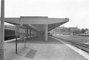
The 1954 Portishead railway station, in 1960 | |
| Operation | |
| Opened | 1867 |
| Owner | Network Rail |
| Events | |
| Closed | 1981 |
| Repoened to Portbury | 2002 |
| Technical | |
| Track gauge | 1,435 mm (4 ft 8 1⁄2 in) |
| Old gauge | 7 ft 1⁄4 in (2,140 mm) |
Portishead Railway | |||||||||||||||||||||||||||||||||||||||||||||||||||||||||||||||||||||||||||||||||||||||||||||||||||||||||||||||||||||||||||||||||||||||||||||||||||||||||||||||||||||||||||||||||||||||||||||||||||||||||||||||||||||||||||||||||||||||||||||||||||||||||
|---|---|---|---|---|---|---|---|---|---|---|---|---|---|---|---|---|---|---|---|---|---|---|---|---|---|---|---|---|---|---|---|---|---|---|---|---|---|---|---|---|---|---|---|---|---|---|---|---|---|---|---|---|---|---|---|---|---|---|---|---|---|---|---|---|---|---|---|---|---|---|---|---|---|---|---|---|---|---|---|---|---|---|---|---|---|---|---|---|---|---|---|---|---|---|---|---|---|---|---|---|---|---|---|---|---|---|---|---|---|---|---|---|---|---|---|---|---|---|---|---|---|---|---|---|---|---|---|---|---|---|---|---|---|---|---|---|---|---|---|---|---|---|---|---|---|---|---|---|---|---|---|---|---|---|---|---|---|---|---|---|---|---|---|---|---|---|---|---|---|---|---|---|---|---|---|---|---|---|---|---|---|---|---|---|---|---|---|---|---|---|---|---|---|---|---|---|---|---|---|---|---|---|---|---|---|---|---|---|---|---|---|---|---|---|---|---|---|---|---|---|---|---|---|---|---|---|---|---|---|---|---|---|---|---|---|---|---|---|---|---|---|---|---|---|---|---|---|---|---|
Legend
| |||||||||||||||||||||||||||||||||||||||||||||||||||||||||||||||||||||||||||||||||||||||||||||||||||||||||||||||||||||||||||||||||||||||||||||||||||||||||||||||||||||||||||||||||||||||||||||||||||||||||||||||||||||||||||||||||||||||||||||||||||||||||
The Portishead Railway is a branch line railway running from Portishead in Somerset to the main line immediately west of Bristol, England.[1] It was constructed by the Bristol & Portishead Pier and Railway Company, but it was always operated by its main line neighbour, and was more usually thought of as the Portishead branch or the Portishead railway.
It opened as a broad gauge (7 ft 0¼ in) line to connect new docks at Portbury, at the west side of the mouth of the River Avon, with the railway network. The line opened to Portishead in 1867, and to the docks in 1879.
The docks were always overshadowed by Bristol and Avonmouth docks. The ordinary passenger service declined in the twentieth century, leading to closure to passengers in 1964, and to all traffic in 1981.
When a new high capacity freight terminal was opened at the site of the Royal Portbury Dock, the line as far as that point was reopened to accommodate the new traffic, in 2002. Public consultation took place in 2015 regarding the reopening the entire line to passenger traffic in 2019, as part of the MetroWest proposals.
History
Getting authorisation
In the seventeenth and eighteenth centuries, Bristol harbour had been paramount as the focus of international trade with the New World. However the city centre location, and the difficult tidal negotiation of the Avon valley, was increasingly a constraint on development, particularly as larger vessels came into use. A number of schemes were put forward without success, but in 1846 the Portbury Pier and Railway Company obtained parliamentary authority to build a floating pier near Portbury, on the west side of the Avon near its mouth, and a railway to connect it to Bristol. Isambard Kingdom Brunel had proposed the development, and the railway was to be operated on the atmospheric principle, in which trains were propelled by a piston in a tube between the rails, from which the air ahead of the train had been exhausted by stationary steam engines.
Unfortunately at this time the collapse of investor confidence following the Railway Mania was taking effect, therefore finance for the work could not be raised and the new company was dissolved.[2]
In 1849 a small stone pier was built at Portishead, and packet steamers unloaded passengers there from that time; but this did little to reduce the desire to improve the city's port facilities, and competing factions tried to get approval for their schemes. In July 1862 the Bristol Port Railway and Pier Company obtained Parliamentary authority for a railway on the eastern side of the Avon at "Clifton" (actually Hotwells), to a new dock at Avonmouth. This line opened in March 1865.
Those who favoured a port on the western side of the Avon were not deterred by the progress of the alternative, and formulated a scheme for a dock at Portbury, and a railway to serve it running from a junction with the Bristol and Exeter Railway (B&ER), with a branch to Portishead. The Company would be the Bristol & Portishead Pier & Railway Company. The main line would have curved sharply to the north before reaching Portished, and run directly to a northwards pier on the coast somewhat east of the present Portbury Wharf location. The branch was to continue directly west from a junction near Sheepway Gate Farm to the Portishead station. This scheme easily got its authorising Act, on 29 June 1863 with a capital of £300,000 and borrowing powers of £66,600.
Construction, and a change of location
Work progressed swiftly, and a portion may[note 1] have been opened in early 1865 from Rownham near Clifton Bridge to the junction with the B&ER main line near the Telegraph Inn, Bedminster.
A number of changes were made to the intended route as work progressed, and the most significant was the change from a pier at Portbury to a dock at Portishead. The pier would have been exposed to westerly winds and would have had limited accommodation for the reception and loading of vessels. The intended Portishead branch became the main line, curving north at Portishead to service the west side of the new dock, and the Portbury section of the originally intended main line was abandoned; these changes were authorised in a new Act of 1866. Evidently the dock required more expenditure than the pier, and an additional £66,000 of share capital and £20,000 in loans were authorised.
The access to the new Dock required a crossing of Portishead Pill on a curve, and a wooden trestle viaduct of 23 spans was required.
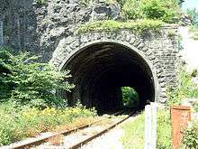
Colonel Yolland of the Board of Trade carried out an inspection of the line on 12 April 1867. He noted that the gradients and curves were significantly inferior to those on the original 1863 design; this probably indicates that they were sacrificed to reduce earthworks and avoid one of the tunnels. The line was 9 miles 11½ chains in length, with an additional 48½ chains at the dock. The track was broad gauge, and there were stations at Clifton Bridge, Pill, Portbury and Portishead, and a siding at Ashton Vale Works; there was an engine turntable at Portishead. However Yolland found numerous shortcomings; as well as fencing deficiencies there were inadequate clearances to two bridge abutments and to retaining walls, and in the No. 2 Tunnel; and proper signalling needed to be provided at the junction with the B&ER and at the Ashton Vale siding.
These and other shortcomings were attended to at once, and the line opened on 18 April 1867. The train service in 1870 was eight trains each way daily, with a journey time of 30 to 35 minutes; there was one train each way on Sundays, the return to Bristol leaving at 8.30 p.m.[2]
MacDermot describes the original opening: On 18 April 1867 the 9½ mile single line opened, constructed on the broad gauge (7 ft 0¼ in). There were four tunnels, respectively 59, 232, 88 and 665 yards long, and the stations on the line were Clifton Bridge, Pill, Portbury and Portishead.[3]
Shipping
The emphasis now was on passenger and ordinary goods traffic, and the original objective, the shipping facility, was on the back burner; reporting the opening, the Bristol Times said, "It is intended shortly to commence a port, which is expected to occupy about two years in the erection."[4]
However, in June 1868 a tidal pier was opened, and by April 1870 a low water extension was ready. Vincent says[5] that the railway company itself ran steamer services to Cardiff and Newport, and summer excursions to Ilfracombe.
Gauge conversion
The Great Western Railway progressively converted its main lines and branches to standard gauge, 4 ft 8½ in, and the Portishead line, still the property of the Bristol & Portishead Pier and Railway Company, was converted between Saturday 24 and Tuesday 27 January 1880.[3]
Connection to the Bristol Harbour lines
By Act of Parliament of 1897, the GWR was authorised to make a connection between the branch and the Bristol Harbour Railway, and also with the north side of the Floating Harbour, following agreement with the Corporation of Bristol. These lines were completed to Canons Marsh and, via the water-hydraulic powered Ashton Swing Bridge to Wapping Wharf, opening to goods traffic on 4 October 1906, together with the West Loop at Ashton Gate, facing Exeter.[3]
Closure
Passenger services were discontinued in 1964 as part of the Reshaping of British Railways report. Freight was discontinued in 1981 but the railway was not dismantled. In 1985 a series of steam excursions ran along the line as part of the "GW150" celebrations. This is thought to be the last commercial use before the line was rebuilt.
Route
The line branches northwards from the Bristol - Exeter main line at Parson Street Junction, originally called Portishead Junction, immediately west of Parson Street Station in south Bristol. From here it runs north along the southwest bank of the River Avon. At Ashton junction, the former line to Bristol Harbour diverged to the right. Immediately north of the site of the junction, the first station was Ashton Gate, opened in 1906,[note 2] followed by Clifton Bridge station, half a mile south of the Clifton Suspension Bridge itself.
Now in the Avon Gorge, the railway runs through No. 1 Tunnel where the Clifton Suspension Bridge runs overhead. Next is Nightingale Valley Halt, opened in 1928 and closed in 1932, where a footpath leads up to the Leigh Woods suburb of Bristol; the site of the halt is then followed by No. 2 Tunnel. There were several small quarries adjacent to the line as far as Sandstone Tunnel. There was then a crossing loop at Oakwood, approximately opposite Sea Mills.
The line then swings away westwards to Ham Green Halt, opened in 1926 to serve a hospital. The longer Pill tunnel was next, followed by Pill viaduct and passenger station, and then Portbury Shipyard station; the latter was built in 1918 to serve a planned shipyard, but this was never built and the station closed in 1928. Portbury is the next station, followed by the terminus of the passenger railway, Portishead, as the line swerves north-eastwards. The line originally continued beyond the passenger station in that direction to the Pier. This extension closed in 1954.
A west curve was constructed at the main line junction west of Parson Street, forming a triangle there.
The derelict shell of the Portbury Shipyard building (1913) remains to the north of the line. A short line branched off back towards the river at this point to serve the proposed development. In 1954 the original Portishead station was demolished, to provide space for the second Portishead power station, and a new station constructed in a new location, lasting only a decade before the line stopped carrying passengers.
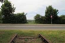
The original line towards Portishead is severed just north of Pill, where the line to the Royal Portbury Dock leads off to the north, crossing the adjoining cyclepath on a low concrete bridge. No points have been installed to create a junction with the former line onwards to Portishead, although the derelict track remains in situ from here towards Portishead, passing under the M5 motorway via a bridge that was constructed with sufficient clearance to allow for electrification.
The railway alignment has been safeguarded by local planning policies, and when the site of Portishead station was redeveloped as a Waitrose supermarket, a nearby site was safeguarded for a potential new station. The alignment is breached on the southern approach to Portishead by Quays Avenue, constructed to serve housing development around the former dockside.[6][7][8]
Reopening of the line
During 2000 and 2001 the railway was rebuilt as far as Pill, and a short spur constructed to the Royal Portbury Dock to transport freight, at a cost of £21 million. The guests for the official opening ceremony were taken from Parson Street station to Portbury on a train hauled by Bristol Industrial Museum's Portbury locomotive on 21 December.[9]
Some local politicians and organisations have been campaigning to have the remaining 3.3 miles (5.3 km) repaired and a new station constructed at Portishead. A campaign group [10] advocates reopening the station and the short stretch of unopened line. The coastal town largely serves as a dormitory town for Bristol workers, and the main route into the city, a single carriageway, the A369, is often unable to cope with the volume of commuter traffic.
The 2006-2011 Joint Local Transport Plan reserved £1 million for the project. In January 2009, it was announced that Network Rail was to carry out a feasibility study on re-opening the line.[11]
During the Rail Priority Conference organised by the West of England Partnership in November 2011, delegates travelled on the line, using sections of track not currently used for passenger traffic.[12][13]
In March 2013, track clearance works began to allow surveying of the original line to Portishead to commence. This was the beginning of the necessary work required to reopen the line for passenger use.[14] Technical assessment of potential sites for a new Portishead station was undertaken in 2013 and followed by public consultation in 2014. The site chosen in 2015 is at the junction of Harbour Road and Quays Avenue, some 600 metres short of the 1950s station.[15]
The project to re-open the Portishead line to passenger rail services is part of the MetroWest programme to improve local rail services across the West of England.[16] This will use both existing and disused rail lines in the Bristol area, operating half-hourly services subject to a proven business case being made and infrastructure constraints. Phase 1 of the programme will include re-opening the Portishead line to passenger services and increasing the frequency of services on the routes to Severn Beach and Bath. The project is being led by North Somerset Council on behalf of four West of England councils (Bath & North East Somerset, Bristol City, South Gloucestershire, and North Somerset).
Current operations
The route is currently served by DB Schenker, Freightliner and GB Railfreight services. The major freight flows along the line are bulk coal and newly delivered vehicles. All services are operated by Class 66 or Class 70 locomotives.
See also
- Weston, Clevedon and Portishead Light Railway, a 13.8 miles (22.2 km) standard gauge light railway which operated between Weston-super-Mare and Portishead
Notes
Citations
- ↑ Christopher Awdry, Encyclopaedia of British Railway Companies, Guild Publishing, London, 1990, ISBN 1-85260-049-7
- 1 2 Mike Vincent, Reflections on the Portishead Branch, Oxford Publishing Co, Poole, 1983, ISBN 0-86093-190-0
- 1 2 3 E T MacDermot, The Great Western Railway, volume 2, published by the Great Western Railway, London, 1931
- ↑ Bristol Times and Mirror newspaper, 20 April 1867, quoted in Vincent
- ↑ Vincent, page 37
- ↑ "Portishead Rail Station Location Scheme Consultation Report" (PDF). Travelwest. October 2014. p. 39. Retrieved 12 November 2016.
- ↑ Col M H Cobb, The Railways of Great Britain, a Historical Atlas, Ian Allan Publishing Ltd, Shepperton, 2003, ISBN 0711030030
- ↑ R A Cooke, Atlas of the Great Western Railway 1947, Wild Swan Publications Ltd, Didcot, 1997
- ↑ "Avonside along the Avonside". Avon Valley Railway. Retrieved 23 January 2009.
- ↑ "Campaign to Reopen the Railway". Portishead Railway Group. Retrieved 23 January 2009.
- ↑ "BBC NEWS - England - Bristol - Town may get new railway station". news.bbc.co.uk. 28 January 2009. Retrieved 29 January 2009.
- ↑ "Rail Priority Conference 2011". travelplus.org.uk. 2011. Retrieved 28 December 2011.
- ↑ Pierce, Ellie; Terretta, Hayley (21 November 2011). "Proposed revival for Bristol Metro scheme". Epigram. University of Bristol Student Union. Retrieved 28 December 2011.
- ↑ "Portishead railway line cleared ahead of track checks". BBC News. BBC. 11 March 2013. Retrieved 11 March 2013.
- ↑ "Portishead rail project updates". North Somerset Council. Retrieved 12 November 2016.
- ↑ "Metrowest: Phase 1". Travelwest. Retrieved 12 November 2016.
References
- Portishead Railway Group, 2006. "History of the Portishead Railway." Accessed 2006-04-15.
- Transcript of House of Commons debate on reopening the railway, 24 January 2005
External links
| Wikimedia Commons has media related to Portishead Railway. |
- Portishead Railway Group
- Photographs of the Portishead Railway from BBC Bristol
- Friends of Suburban Bristol Railways