Portsoken
| Ward of Portsoken | |
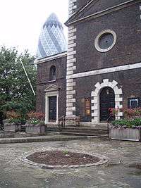 St Botolph's Aldgate[1] |
|
 Ward of Portsoken |
|
| Population | 985 (2011 Census. Ward)[2] |
|---|---|
| London borough | |
| Ceremonial county | Greater London |
| Region | London |
| Country | England |
| Sovereign state | United Kingdom |
| Post town | LONDON |
| Postcode district | E1 |
| Postcode district | EC3 |
| Dialling code | 020 |
| Police | Metropolitan |
| Fire | London |
| Ambulance | London |
| EU Parliament | London |
| UK Parliament | Cities of London and Westminster |
| London Assembly | |
Coordinates: 51°30′52″N 0°04′31″W / 51.5144°N 0.0752°W
Portsoken is a historical district in the City of London, located outside the former London Wall, on the eastern part of the City, near Aldgate. It is one of the City's 25 ancient wards.
Aldgate and Tower wards lie to the west, and its eastern boundary is defined by Middlesex and Mansell Streets in Whitechapel. To the north, the boundary meets Bishopsgate and Spitalfields; to the south, the former liberties of the Royal Mint.
The Sir John Cass's Foundation Primary School is now located in this (largely residential) ward, added in the 2003 boundary review, and is the only part of the ward within the former wall.
History
John Stow's survey of London records that the ‘soke’ (later ‘liberty’) was granted in Saxon times east of Aldgate to a Guild of Knights in exchange, essentially, for regular jousting. Norman kings confirmed these rights but later the land was voluntarily transferred to the Priory of the Holy Trinity by the descendants of the Guild.
In 1120 or 1121 (the exact date is unknown), Portsoken was granted as a liberty to the Priory of Holy Trinity, which had been founded in 1107 by Queen Matilda, the wife of King Henry I. The sitting prior of Holy Trinity became, ex officio, an alderman of the City of London Corporation representing Portsoken ward, and remained so until the Dissolution of the Monasteries by King Henry VIII in 1531.[3]
In 1332, a tax assessment showed 23 taxpayers in Portsoken, however, this figure consisted only of freemen of the City of London who possessed moveable property worth more than 10 shillings, and so did not include the poor, non-citizens, or members of religious orders.[4] A later subsidy roll from 1582 showed that the ward's taxpayers had been assessed to pay a total of 57 pounds, 11 shillings and 4 pence.[5]
Boundary changes in 1994 altered the City-Tower Hamlets boundary in the area quite considerably. A small part of Portsoken ward was removed to Tower Hamlets, however a much larger area was transferred to the City from Tower Hamlets, though not all initially to Portsoken.[6] With the 2003 ward boundary review, much of the additional territory in this part of the City was given to Portsoken, as it consisted mainly of residential and related buildings. With the loss of some business-dominated parts, the gaining of this residential area and the gaining of the primary school, Portsoken is now regarded as one of the City's four residential wards, with a population of 985 (2011).[7]
Politics

Portsoken is one of 25 wards in the City of London, each electing an alderman to the Court of Aldermen and commoners (the City equivalent of a councillor) elected to the Court of Common Council of the City of London Corporation. Only electors who are Freemen of the City are eligible to stand for election.
Keith Joseph, Secretary of State for Industry from 1979–1981 and Secretary of State for Education and Science from 1981–1986 under Margaret Thatcher, received a life peerage as "Baron Joseph, of Portsoken in the City of London", in 1987. His father was Lord Mayor in 1942-3.
Peter Levene (Lord Mayor 1998-1999) adopted the title "Baron Levene of Portsoken" upon his elevation to the peerage in 1997.
In 2014 William Taylor was elected as the first Labour councillor in the City of London representing Portsoken ward.[8]
See also
References
- ↑ If you look carefully you can see the Portsoken Bulletin, detailing the ward officers.
- ↑ "City of London Ward population 2011". Neighbourhood Statistics. Office for National Statistics. Retrieved 16 October 2016.
- ↑ p45, Inwood, Stephen, A History of London (Macmillan, 1998), ISBN 0-333-67154-6
- ↑ p61, Inwood, Stephen, A History of London (Macmillan, 1998), ISBN 0-333-67154-6
- ↑ 1582 London Subsidy Rolls, British History Online
- ↑ The City and London Borough Boundaries Order 1993 (enacted 1994)
- ↑ http://neighbourhood.statistics.gov.uk/dissemination/LeadTableView.do?a=7&b=6505055&c=Portsoken&d=14&e=61&g=6317325&i=1001x1003x1032x1004&m=0&p=1&r=1&s=1366839209547&enc=1&dsFamilyId=2491
- ↑ Taylor,William. "You'd never guess who lives in the super-rich Square Mile", The Guardian, London, 1 June 2014. Retrieved on 5 June 2014.
External links
- City of London Corporation Map of Portsoken ward (2003 —)
- Map of Early Modern London: Portsoken Ward - Historical Map and Encyclopedia of Shakespeare's London (Scholarly)
| Wards |  | |
|---|---|---|
| Enclaves | ||
| Localities | ||
| Attractions |
| |
| Notable structures | ||
| Civil parishes | ||
| Bridges | ||
| Rail and tube stations | ||
| Topics | ||
| ||